Property Record
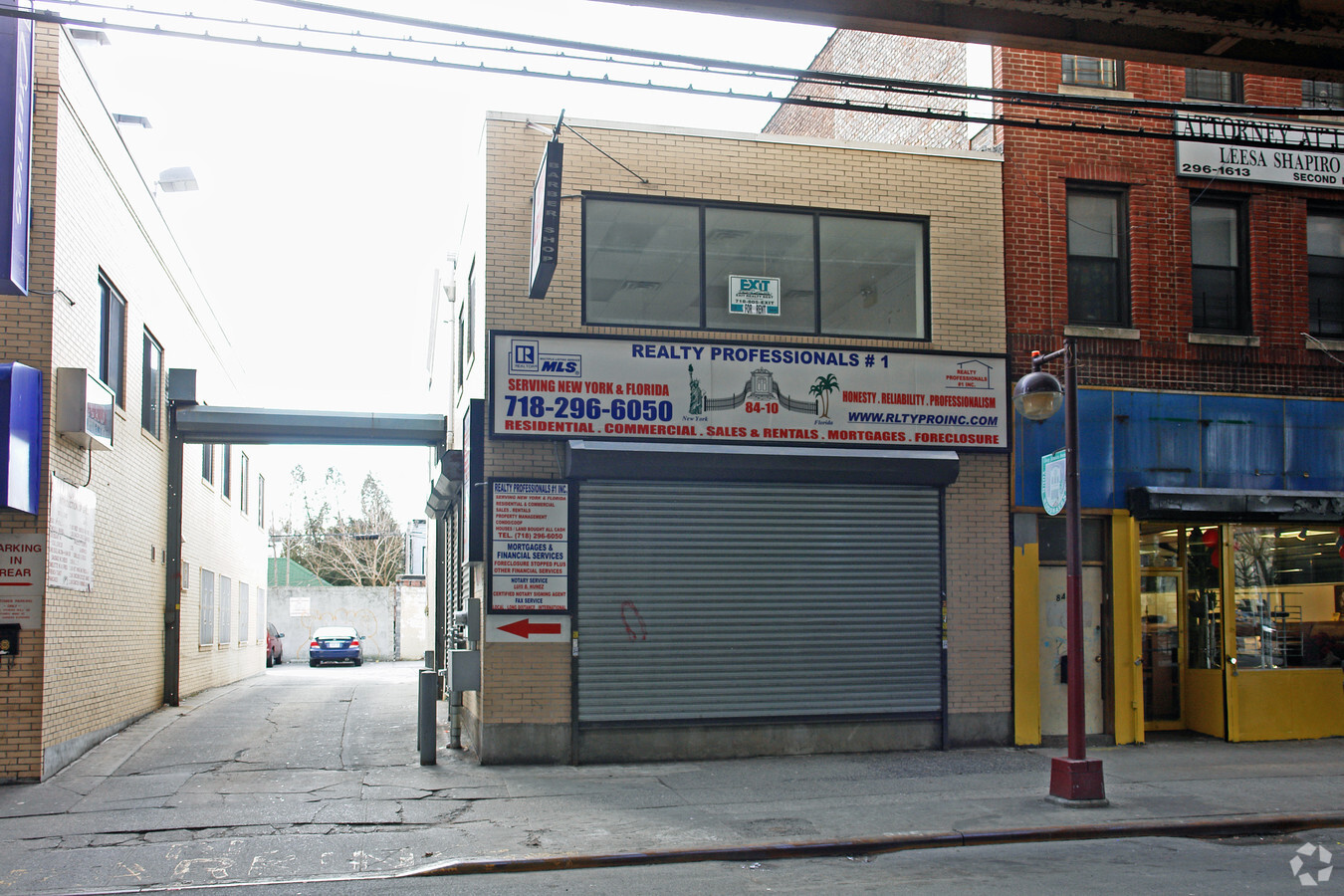
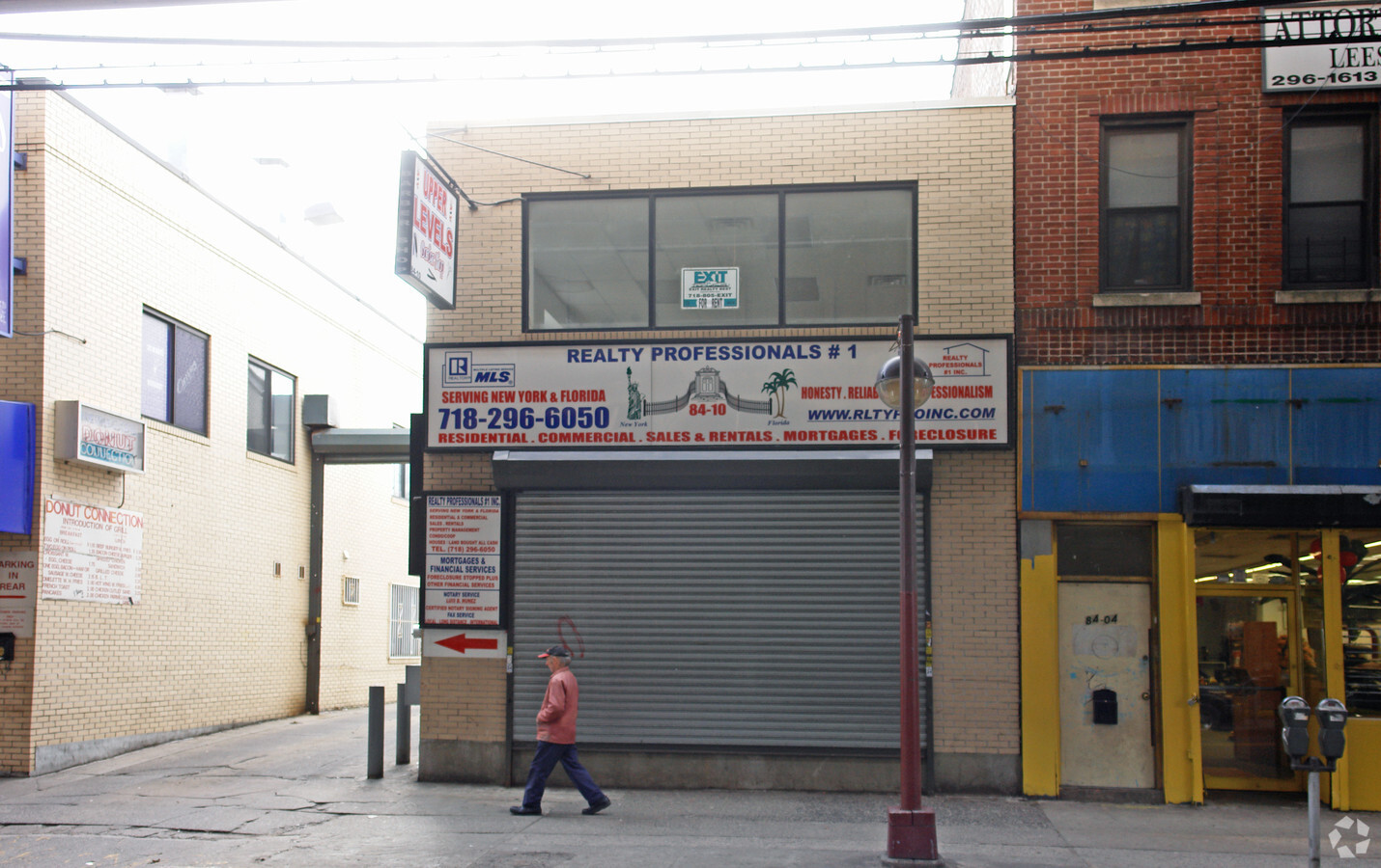
8410 Jamaica Ave, Woodhaven, NY 11421
NEARBY LISTINGS FOR SALE OR LEASE
Property Detail
8410 Jamaica Ave
08919-0020
Hitchcoks Map Of Union Course Park
Storebuilding
Queens
X
New York
3604970228F
20
2024
0.06 AC
2024
Central Queens
001000
Long Island (New York)
2,360 SF
New York-Jersey City-White Plains, NY-NJ
DEMOGRAPHICS near 8410 Jamaica Ave
1 Mile
3 Mile
5 Mile
2024 Total Population
80,813
776,137
2,174,258
2029 Population
72,490
717,933
2,023,810
Pop Growth 2024-2029
(10.30%)
(7.50%)
(6.92%)
Average Age
39
40
40
2024 Total Households
23,527
272,556
757,166
HH Growth 2024-2029
(10.86%)
(7.62%)
(7.16%)
Median Household Inc
$72,400
$69,991
$65,210
Avg Household Size
3.30
2.70
2.70
2024 Avg HH Vehicles
1.00
1.00
1.00
Median Home Value
$696,869
$669,380
$684,291
Median Year Built
1946
1949
1950
Nearby Places
- Restaurants
- Banks
- Shops
- Fitness
- Groceries
PUBLIC TRANSPORTATION
TRANSIT/SUBWAY
85 Street-Forest Parkway (J - New York MTA Subway (The Subway))
DRIVE
WALK
Distance
85 Street-Forest Parkway (J - New York MTA Subway (The Subway))
0 min
0 min
0.0 mi
75 Street-Elderts Lane (J - New York MTA Subway (The Subway), Z - New York MTA Subway (The Subway))
DRIVE
WALK
Distance
75 Street-Elderts Lane (J - New York MTA Subway (The Subway), Z - New York MTA Subway (The Subway))
0 min
7 min
0.4 mi
Woodhaven Boulevard (J,Z Line) (J - New York MTA Subway (The Subway), Z - New York MTA Subway (The Subway))
DRIVE
WALK
Distance
Woodhaven Boulevard (J,Z Line) (J - New York MTA Subway (The Subway), Z - New York MTA Subway (The Subway))
1 min
8 min
0.5 mi
Cypress Hills (J - New York MTA Subway (The Subway))
DRIVE
WALK
Distance
Cypress Hills (J - New York MTA Subway (The Subway))
1 min
13 min
0.7 mi
104 Street (J,Z Line) (J - New York MTA Subway (The Subway), Z - New York MTA Subway (The Subway))
DRIVE
WALK
Distance
104 Street (J,Z Line) (J - New York MTA Subway (The Subway), Z - New York MTA Subway (The Subway))
1 min
16 min
0.8 mi
COMMUTER RAIL
Kew Gardens Station (Babylon Branch - Long Island Rail Road, Hempstead Branch - Long Island Rail Road, Long Beach Branch - Long Island Rail Road, Port Jefferson Branch - Long Island Rail Road)
DRIVE
WALK
Distance
Kew Gardens Station (Babylon Branch - Long Island Rail Road, Hempstead Branch - Long Island Rail Road, Long Beach Branch - Long Island Rail Road, Port Jefferson Branch - Long Island Rail Road)
6 min
2.6 mi
Forest Hills Station (Babylon Branch - Long Island Rail Road, Hempstead Branch - Long Island Rail Road, Long Beach Branch - Long Island Rail Road, Port Jefferson Branch - Long Island Rail Road)
DRIVE
WALK
Distance
Forest Hills Station (Babylon Branch - Long Island Rail Road, Hempstead Branch - Long Island Rail Road, Long Beach Branch - Long Island Rail Road, Port Jefferson Branch - Long Island Rail Road)
7 min
2.6 mi
AIRPORT
John F Kennedy International
DRIVE
WALK
Distance
John F Kennedy International
12 min
8.0 mi
Laguardia
DRIVE
WALK
Distance
Laguardia
16 min
8.8 mi
Newark Liberty International
DRIVE
WALK
Distance
Newark Liberty International
39 min
20.7 mi
Freight Ports
NY - Red Hook Container Terminal
DRIVE
WALK
Distance
NY - Red Hook Container Terminal
21 min
9.4 mi
Nearby Properties
Address
Land Use
TOTAL SIZE
Lot Size
Zoning
Address
Land Use
TOTAL SIZE
Lot Size
Zoning
1,845,252 SF
172 AC
C8-1
Address
Land Use
TOTAL SIZE
Lot Size
Zoning
772,163 SF
5.24 AC
C4-5X
Address
Land Use
TOTAL SIZE
Lot Size
Zoning
54,170 SF
229.57 AC
PARK
Address
Land Use
TOTAL SIZE
Lot Size
Zoning
1,292,074 SF
C4-2F
Address
Land Use
TOTAL SIZE
Lot Size
Zoning
1,516,458 SF
5.97 AC
R7-1
Address
Land Use
TOTAL SIZE
Lot Size
Zoning
484,470 SF
2.48 AC
R6
Address
Land Use
TOTAL SIZE
Lot Size
Zoning
126.85 AC
PARK
Address
Land Use
TOTAL SIZE
Lot Size
Zoning
1,000 SF
210.07 AC
R3-2
Address
Land Use
TOTAL SIZE
Lot Size
Zoning
1,572,198 SF
22.06 AC
M1-2
Address
Land Use
TOTAL SIZE
Lot Size
Zoning
2,193 SF
94.72 AC
PARK
Address
Land Use
TOTAL SIZE
Lot Size
Zoning
360,000 SF
5.88 AC
C4-2
Address
Land Use
TOTAL SIZE
Lot Size
Zoning
307,038 SF
7.84 AC
M1-1
Address
Land Use
TOTAL SIZE
Lot Size
Zoning
33.98 AC
C4-2
Address
Land Use
TOTAL SIZE
Lot Size
Zoning
523,000 SF
12 AC
M1-1
Address
Land Use
TOTAL SIZE
Lot Size
Zoning
320,535 SF
1.52 AC
C4-4A
Address
Land Use
TOTAL SIZE
Lot Size
Zoning
1,136,208 SF
30.25 AC
R5
Address
Land Use
TOTAL SIZE
Lot Size
Zoning
142,931 SF
3.28 AC
C4-2
Address
Land Use
TOTAL SIZE
Lot Size
Zoning
158,402 SF
3.64 AC
C4-2
Address
Land Use
TOTAL SIZE
Lot Size
Zoning
230,580 SF
3.40 AC
C8-1
Address
Land Use
TOTAL SIZE
Lot Size
Zoning
535,609 SF
0.82 AC
C6-4
Address
Land Use
TOTAL SIZE
Lot Size
Zoning
203,132 SF
3.09 AC
C4-2
Address
Land Use
TOTAL SIZE
Lot Size
Zoning
497,600 SF
6.79 AC
C4-4
Address
Land Use
TOTAL SIZE
Lot Size
Zoning
528,000 SF
6 AC
R5B
Address
Land Use
TOTAL SIZE
Lot Size
Zoning
192,200 SF
9.70 AC
R4
Address
Land Use
TOTAL SIZE
Lot Size
Zoning
940,800 SF
11.54 AC
R5
Address
Land Use
TOTAL SIZE
Lot Size
Zoning
4,279,575 SF
144.16 AC
PARK
Address
Land Use
TOTAL SIZE
Lot Size
Zoning
107,000 SF
1.84 AC
R6
Address
Land Use
TOTAL SIZE
Lot Size
Zoning
454,645 SF
0.95 AC
C4-4
Address
Land Use
TOTAL SIZE
Lot Size
Zoning
552,216 SF
9.41 AC
R4
Address
Land Use
TOTAL SIZE
Lot Size
Zoning
202,615 SF
1.33 AC
R7-1
The World's #1 Commercial Real Estate Marketplace
Connect with us
© 2025 CoStar Group
The information above has been obtained from sources believed reliable. While we do not doubt its accuracy we have not verified it and make no guarantee, warranty or representation about it. It is your responsibility to independently confirm its accuracy and completeness. Any projections, opinions, assumptions, or estimates used are for example only and do not represent the current or future performance of the property. The value of this transaction to you depends on tax and other factors which should be evaluated by your tax, financial, and legal advisors. You and your advisors should conduct a careful, independent investigation of the property to determine to your satisfaction the suitability of the property for your needs.