Property Record
8420 S 143Rd St E, Derby, KS 67037
NEARBY LISTINGS FOR SALE OR LEASE
-
-
View all Derby listings for sale on LoopNet.com
Property Detail
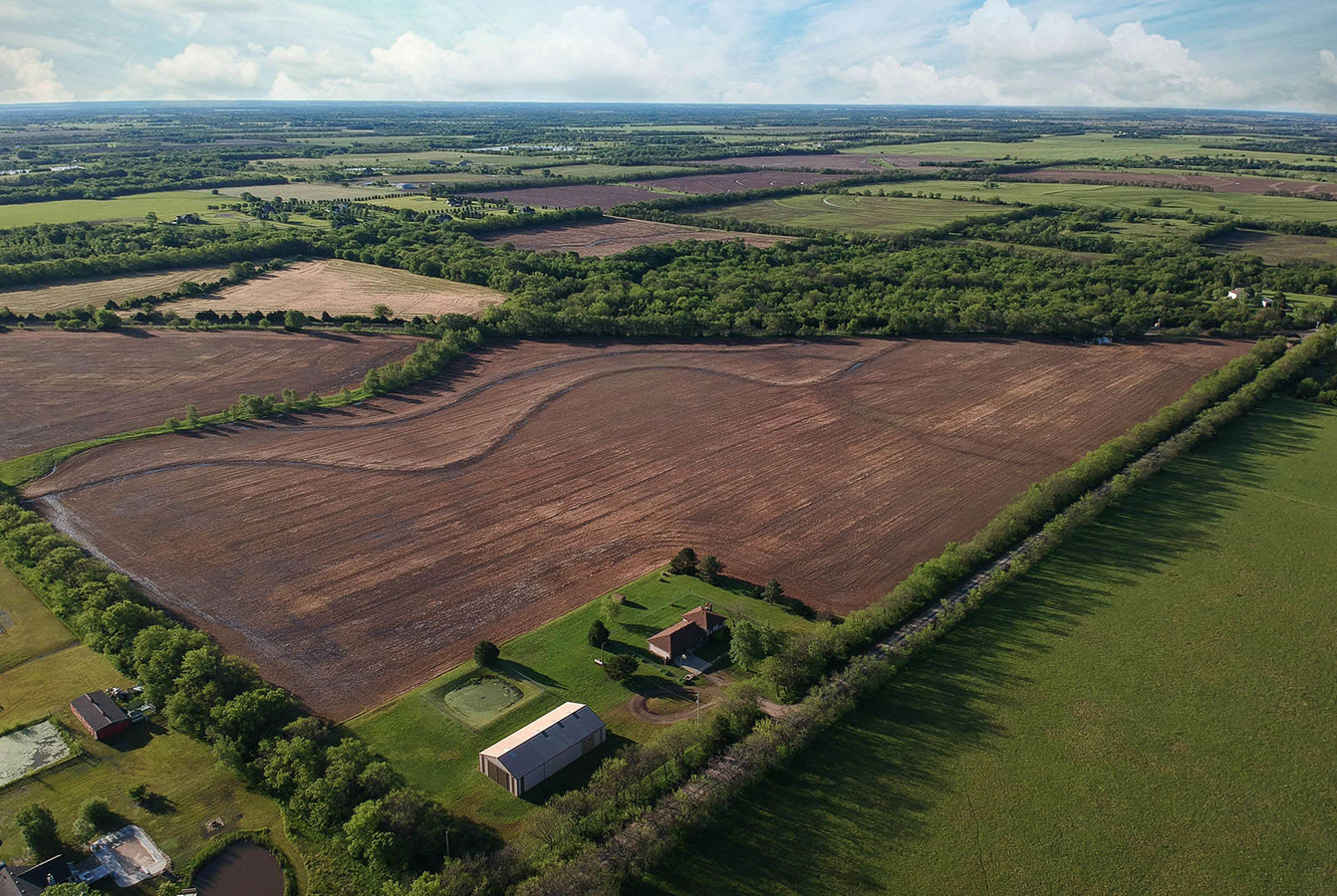
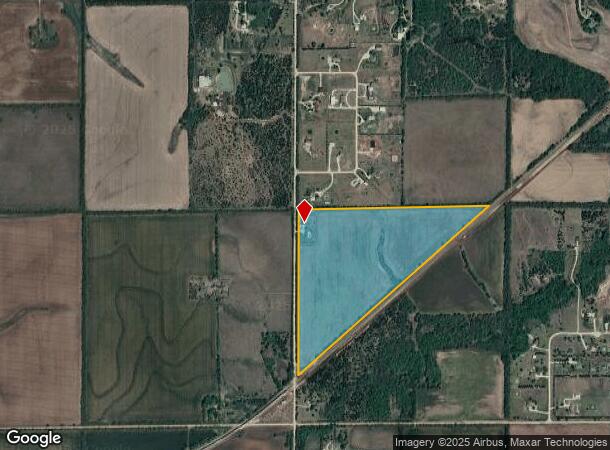
8420 S 143Rd St E
231-12-0-32-00-001.00
THAT PT SW1/4 LY N & W OF RR ROW SEC 12-29-2E
Farms
Sedgwick
X
Kansas
20173C0545G
1.12 AC
2023
Derby/Haysville/Mulvane
2023
Wichita
009901
Wichita, KS
2,896 SF
DEMOGRAPHICS near 8420 S 143Rd St E
1 Mile
3 Mile
5 Mile
2024 Total Population
179
3,963
21,943
2029 Population
174
3,992
21,940
Pop Growth 2024-2029
(2.79%)
+ 0.73%
(0.01%)
Average Age
43
40
40
2024 Total Households
62
1,381
8,173
HH Growth 2024-2029
(3.23%)
+ 0.72%
(0.32%)
Median Household Inc
$103,333
$99,374
$86,936
Avg Household Size
2.60
2.80
2.60
2024 Avg HH Vehicles
3.00
3.00
2.00
Median Home Value
$276,315
$193,860
$215,972
Median Year Built
1988
1991
1992
Nearby Places
- Restaurants
- Banks
- Shops
- Fitness
- Groceries
PUBLIC TRANSPORTATION
AIRPORT
Wichita Dwight D Eisenhower Ntl
DRIVE
WALK
Distance
Wichita Dwight D Eisenhower Ntl
41 min
23.0 mi
Freight Ports
Tulsa Port Of Catoosa
DRIVE
WALK
Distance
Tulsa Port Of Catoosa
217 min
190.7 mi
SALE & LEASE HISTORY
LISTING DATE
SALE/LEASE

Jun 03, 2019
For Sale
Nearby Properties
Address
Land Use
TOTAL SIZE
Lot Size
Zoning
Address
Land Use
TOTAL SIZE
Lot Size
Zoning
97.20 AC
Address
Land Use
TOTAL SIZE
Lot Size
Zoning
279,330 SF
40.10 AC
Address
Land Use
TOTAL SIZE
Lot Size
Zoning
18,996 SF
5.30 AC
Address
Land Use
TOTAL SIZE
Lot Size
Zoning
13,318 SF
1.70 AC
Address
Land Use
TOTAL SIZE
Lot Size
Zoning
15,186 SF
9.70 AC
Address
Land Use
TOTAL SIZE
Lot Size
Zoning
6,554 SF
2.50 AC
Address
Land Use
TOTAL SIZE
Lot Size
Zoning
0.96 AC
Address
Land Use
TOTAL SIZE
Lot Size
Zoning
61,650 SF
5 AC
Address
Land Use
TOTAL SIZE
Lot Size
Zoning
4,923 SF
1 AC
Address
Land Use
TOTAL SIZE
Lot Size
Zoning
1,200 SF
21.40 AC
Address
Land Use
TOTAL SIZE
Lot Size
Zoning
5,720 SF
0.73 AC
Address
Land Use
TOTAL SIZE
Lot Size
Zoning
9,684 SF
0.43 AC
Address
Land Use
TOTAL SIZE
Lot Size
Zoning
4,100 SF
1.11 AC
Address
Land Use
TOTAL SIZE
Lot Size
Zoning
33,718 SF
5.50 AC
Address
Land Use
TOTAL SIZE
Lot Size
Zoning
2,520 SF
0.44 AC
Address
Land Use
TOTAL SIZE
Lot Size
Zoning
17.10 AC
Address
Land Use
TOTAL SIZE
Lot Size
Zoning
8,970 SF
1.10 AC
Address
Land Use
TOTAL SIZE
Lot Size
Zoning
18.70 AC
Address
Land Use
TOTAL SIZE
Lot Size
Zoning
11,014 SF
1.83 AC
Address
Land Use
TOTAL SIZE
Lot Size
Zoning
4,672 SF
0.64 AC
Address
Land Use
TOTAL SIZE
Lot Size
Zoning
7,200 SF
2.60 AC
Address
Land Use
TOTAL SIZE
Lot Size
Zoning
8,289 SF
9.07 AC
RR
Address
Land Use
TOTAL SIZE
Lot Size
Zoning
8,644 SF
6.47 AC
RR
Address
Land Use
TOTAL SIZE
Lot Size
Zoning
3,367 SF
1.48 AC
RR
Address
Land Use
TOTAL SIZE
Lot Size
Zoning
Address
Land Use
TOTAL SIZE
Lot Size
Zoning
7,673 SF
2.55 AC
RR
Address
Land Use
TOTAL SIZE
Lot Size
Zoning
20,000 SF
2.50 AC
Address
Land Use
TOTAL SIZE
Lot Size
Zoning
4,000 SF
2.20 AC
Address
Land Use
TOTAL SIZE
Lot Size
Zoning
7,902 SF
2.32 AC
RR
Address
Land Use
TOTAL SIZE
Lot Size
Zoning
2,961 SF
1.36 AC
RR
The World's #1 Commercial Real Estate Marketplace
Connect with us
© 2025 CoStar Group
The information above has been obtained from sources believed reliable. While we do not doubt its accuracy we have not verified it and make no guarantee, warranty or representation about it. It is your responsibility to independently confirm its accuracy and completeness. Any projections, opinions, assumptions, or estimates used are for example only and do not represent the current or future performance of the property. The value of this transaction to you depends on tax and other factors which should be evaluated by your tax, financial, and legal advisors. You and your advisors should conduct a careful, independent investigation of the property to determine to your satisfaction the suitability of the property for your needs.