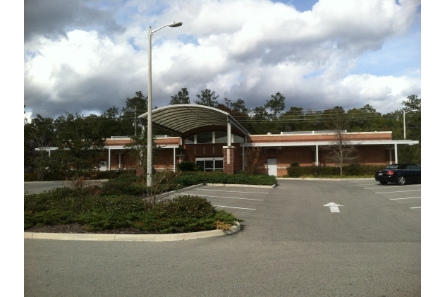
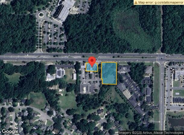
Property Record
8475 Nw 39Th Ave, Gainesville, FL 32606
NEARBY LISTINGS FOR SALE OR LEASE
Property Detail
8475 Nw 39Th Ave
06230-005-001
Turkey Creek Condo
Hospitalpublic
COM NW COR SEC S 50 FT TO S R/W 39TH AVE E 1803.06 FT TO POB E 429.44 FT S 503.69 FT TO N BDRY LINE OF NORTHRIDGE PHASE 1 UNIT 1 W 429.50 FT N 510.64 FT OR 3540/ 1353 (LESS COMMON AREA PER OR 3833/1570) (LESS COM NW COR SEC S 50 FT E 1803.06 FT S 248
X
Alachua
12001C0285E
Florida
2023
1.20 AC
2024
Northwest Gainesville
001701
Other Market Areas
8,784 SF
Gainesville, FL
DEMOGRAPHICS near 8475 Nw 39Th Ave
1 Mile
3 Mile
5 Mile
2024 Total Population
3,619
35,045
104,272
2029 Population
3,673
36,685
109,802
Pop Growth 2024-2029
+ 1.49%
+ 4.68%
+ 5.30%
Average Age
41
41
39
2024 Total Households
1,797
14,888
43,367
HH Growth 2024-2029
+ 1.39%
+ 4.74%
+ 5.37%
Median Household Inc
$63,357
$79,222
$76,406
Avg Household Size
1.90
2.30
2.30
2024 Avg HH Vehicles
1.00
2.00
2.00
Median Home Value
$208,772
$313,139
$283,748
Median Year Built
1991
1987
1987
Nearby Places
- Restaurants
- Banks
- Shops
- Fitness
- Groceries
PUBLIC TRANSPORTATION
AIRPORT
Gainesville Regional
DRIVE
WALK
Distance
Gainesville Regional
22 min
10.3 mi
Freight Ports
Jacksonville Port
DRIVE
WALK
Distance
Jacksonville Port
107 min
80.2 mi
Nearby Properties
Address
Land Use
TOTAL SIZE
Lot Size
Zoning
Address
Land Use
TOTAL SIZE
Lot Size
Zoning
317,057 SF
128.93 AC
RP
Address
Land Use
TOTAL SIZE
Lot Size
Zoning
969,793 SF
11.60 AC
MD
Address
Land Use
TOTAL SIZE
Lot Size
Zoning
141,984 SF
20 AC
HM
Address
Land Use
TOTAL SIZE
Lot Size
Zoning
790,684 SF
57.09 AC
U8
Address
Land Use
TOTAL SIZE
Lot Size
Zoning
392,717 SF
47.62 AC
R-2
Address
Land Use
TOTAL SIZE
Lot Size
Zoning
383,664 SF
26.55 AC
R-1A
Address
Land Use
TOTAL SIZE
Lot Size
Zoning
626,679 SF
41.04 AC
A
Address
Land Use
TOTAL SIZE
Lot Size
Zoning
153,592 SF
24.98 AC
R-2
Address
Land Use
TOTAL SIZE
Lot Size
Zoning
794,044 SF
80.54 AC
PD
Address
Land Use
TOTAL SIZE
Lot Size
Zoning
206,071 SF
43.34 AC
A
Address
Land Use
TOTAL SIZE
Lot Size
Zoning
349,789 SF
28.08 AC
PD
Address
Land Use
TOTAL SIZE
Lot Size
Zoning
326,376 SF
39.94 AC
R-2
Address
Land Use
TOTAL SIZE
Lot Size
Zoning
385,880 SF
21.51 AC
PD
Address
Land Use
TOTAL SIZE
Lot Size
Zoning
272,730 SF
20.13 AC
PD
Address
Land Use
TOTAL SIZE
Lot Size
Zoning
297,651 SF
13.66 AC
R-1A
Address
Land Use
TOTAL SIZE
Lot Size
Zoning
210,566 SF
19.13 AC
MU1
Address
Land Use
TOTAL SIZE
Lot Size
Zoning
296,660 SF
21.78 AC
R-3
Address
Land Use
TOTAL SIZE
Lot Size
Zoning
279,819 SF
18.03 AC
R-1B
Address
Land Use
TOTAL SIZE
Lot Size
Zoning
242,053 SF
26.93 AC
R-2A
Address
Land Use
TOTAL SIZE
Lot Size
Zoning
168,261 SF
23.50 AC
BH
Address
Land Use
TOTAL SIZE
Lot Size
Zoning
80,786 SF
15 AC
ED
Address
Land Use
TOTAL SIZE
Lot Size
Zoning
74,722 SF
9.71 AC
PD
Address
Land Use
TOTAL SIZE
Lot Size
Zoning
284,297 SF
19.80 AC
PD
Address
Land Use
TOTAL SIZE
Lot Size
Zoning
152,739 SF
15.30 AC
RMF6
Address
Land Use
TOTAL SIZE
Lot Size
Zoning
120,572 SF
9.11 AC
PD
Address
Land Use
TOTAL SIZE
Lot Size
Zoning
80,709 SF
10.81 AC
MU2
Address
Land Use
TOTAL SIZE
Lot Size
Zoning
135,610 SF
11.01 AC
R-2A
Address
Land Use
TOTAL SIZE
Lot Size
Zoning
223,337 SF
16.10 AC
R-3
Address
Land Use
TOTAL SIZE
Lot Size
Zoning
216,468 SF
17.27 AC
R-2A
Address
Land Use
TOTAL SIZE
Lot Size
Zoning
137,483 SF
8.24 AC
U8
The World's #1 Commercial Real Estate Marketplace
Connect with us
© 2025 CoStar Group
The information above has been obtained from sources believed reliable. While we do not doubt its accuracy we have not verified it and make no guarantee, warranty or representation about it. It is your responsibility to independently confirm its accuracy and completeness. Any projections, opinions, assumptions, or estimates used are for example only and do not represent the current or future performance of the property. The value of this transaction to you depends on tax and other factors which should be evaluated by your tax, financial, and legal advisors. You and your advisors should conduct a careful, independent investigation of the property to determine to your satisfaction the suitability of the property for your needs.