Property Record
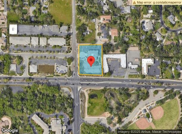
8481 Barton Rd, Granite Bay, CA 95746
NEARBY LISTINGS FOR SALE OR LEASE
Property Detail
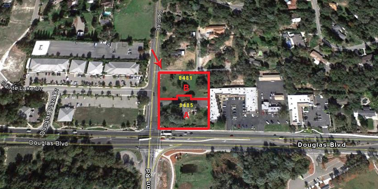
8481 Barton Rd
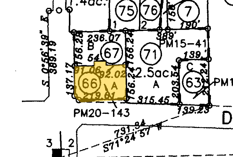
048-101-084
20-143, Parcel Map
Hospitalprivate
1.67 AC PAR B & A PMOR 20 143
X
Placer
06061C1052H
California
2023
1.67 AC
2023
Roseville/Rocklin
020604
Sacramento
32,537 SF
Sacramento--Roseville--Arden-Arcade, CA
DEMOGRAPHICS near 8481 Barton Rd
1 Mile
3 Mile
5 Mile
2024 Total Population
3,578
41,184
136,797
2029 Population
3,839
43,876
143,197
Pop Growth 2024-2029
+ 7.29%
+ 6.54%
+ 4.68%
Average Age
45
43
43
2024 Total Households
1,285
15,046
50,337
HH Growth 2024-2029
+ 7.47%
+ 6.51%
+ 4.88%
Median Household Inc
$149,456
$143,004
$103,983
Avg Household Size
2.70
2.70
2.50
2024 Avg HH Vehicles
2.00
2.00
2.00
Median Home Value
$880,373
$814,108
$677,915
Median Year Built
1982
1992
1984
Nearby Places
- Restaurants
- Banks
- Shops
- Fitness
- Groceries
PUBLIC TRANSPORTATION
COMMUTER RAIL
Roseville (California Zephyr - Amtrak, Capitol Corridor - Amtrak)
DRIVE
WALK
Distance
Roseville (California Zephyr - Amtrak, Capitol Corridor - Amtrak)
12 min
6.0 mi
Rocklin Amtrak Station (Capitol Corridor - Amtrak)
DRIVE
WALK
Distance
Rocklin Amtrak Station (Capitol Corridor - Amtrak)
11 min
6.9 mi
AIRPORT
Sacramento International
DRIVE
WALK
Distance
Sacramento International
40 min
29.1 mi
Freight Ports
Port of Stockton
DRIVE
WALK
Distance
Port of Stockton
82 min
69.3 mi
Nearby Properties
Address
Land Use
TOTAL SIZE
Lot Size
Zoning
Address
Land Use
TOTAL SIZE
Lot Size
Zoning
638,040 SF
38.70 AC
Address
Land Use
TOTAL SIZE
Lot Size
Zoning
223,623 SF
12.70 AC
Address
Land Use
TOTAL SIZE
Lot Size
Zoning
120,983 SF
17.60 AC
Address
Land Use
TOTAL SIZE
Lot Size
Zoning
154,696 SF
10.80 AC
Address
Land Use
TOTAL SIZE
Lot Size
Zoning
118,155 SF
3.80 AC
Address
Land Use
TOTAL SIZE
Lot Size
Zoning
110,791 SF
7.50 AC
Address
Land Use
TOTAL SIZE
Lot Size
Zoning
139,000 SF
9.30 AC
Address
Land Use
TOTAL SIZE
Lot Size
Zoning
101,964 SF
7.70 AC
Address
Land Use
TOTAL SIZE
Lot Size
Zoning
121,155 SF
4.70 AC
C-2 (PD)
Address
Land Use
TOTAL SIZE
Lot Size
Zoning
103,448 SF
7.50 AC
Address
Land Use
TOTAL SIZE
Lot Size
Zoning
10,800 SF
6.70 AC
RAB100
Address
Land Use
TOTAL SIZE
Lot Size
Zoning
109,098 SF
5.50 AC
Address
Land Use
TOTAL SIZE
Lot Size
Zoning
96,522 SF
19.90 AC
FBX
Address
Land Use
TOTAL SIZE
Lot Size
Zoning
97,278 SF
4.60 AC
Address
Land Use
TOTAL SIZE
Lot Size
Zoning
111,418 SF
10.90 AC
Address
Land Use
TOTAL SIZE
Lot Size
Zoning
80,966 SF
21.80 AC
Address
Land Use
TOTAL SIZE
Lot Size
Zoning
254,982 SF
19.60 AC
Address
Land Use
TOTAL SIZE
Lot Size
Zoning
137,447 SF
10.90 AC
C1UPDC
Address
Land Use
TOTAL SIZE
Lot Size
Zoning
97,279 SF
6.40 AC
Address
Land Use
TOTAL SIZE
Lot Size
Zoning
73,900 SF
7 AC
Address
Land Use
TOTAL SIZE
Lot Size
Zoning
57,405 SF
7.20 AC
Address
Land Use
TOTAL SIZE
Lot Size
Zoning
55,886 SF
6.20 AC
Address
Land Use
TOTAL SIZE
Lot Size
Zoning
60,069 SF
1.40 AC
Address
Land Use
TOTAL SIZE
Lot Size
Zoning
31,722 SF
151.30 AC
RSAGB40
Address
Land Use
TOTAL SIZE
Lot Size
Zoning
56,441 SF
4 AC
Address
Land Use
TOTAL SIZE
Lot Size
Zoning
54,779 SF
3.10 AC
Address
Land Use
TOTAL SIZE
Lot Size
Zoning
69,120 SF
7.50 AC
Address
Land Use
TOTAL SIZE
Lot Size
Zoning
59,181 SF
4.57 AC
C-2 (PD)
Address
Land Use
TOTAL SIZE
Lot Size
Zoning
48,170 SF
4 AC
Address
Land Use
TOTAL SIZE
Lot Size
Zoning
The World's #1 Commercial Real Estate Marketplace
Connect with us
© 2025 CoStar Group
The information above has been obtained from sources believed reliable. While we do not doubt its accuracy we have not verified it and make no guarantee, warranty or representation about it. It is your responsibility to independently confirm its accuracy and completeness. Any projections, opinions, assumptions, or estimates used are for example only and do not represent the current or future performance of the property. The value of this transaction to you depends on tax and other factors which should be evaluated by your tax, financial, and legal advisors. You and your advisors should conduct a careful, independent investigation of the property to determine to your satisfaction the suitability of the property for your needs.