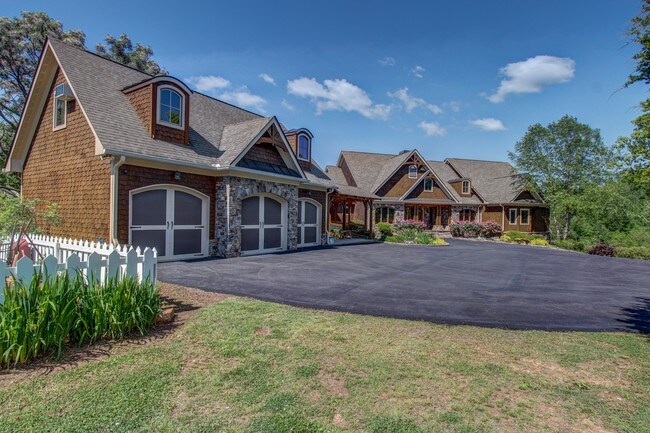
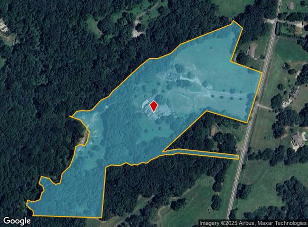
Property Record
8490 Waldrip Rd, Gainesville, GA 30506
NEARBY LISTINGS FOR SALE OR LEASE
Property Detail
8490 Waldrip Rd
Atlanta-Sandy Springs-Roswell, GA
Chattahoochee
304-013
14-1 1120 & 1149
Agriculturalland
Forsyth
A
Georgia
13139C0175G
1120
2024
16.17 AC
2025
N Fulton/Forsyth County
130104
Atlanta
3,779 SF
DEMOGRAPHICS near 8490 Waldrip Rd
1 Mile
3 Mile
5 Mile
2024 Total Population
1,835
15,989
36,162
2029 Population
2,155
18,743
42,330
Pop Growth 2024-2029
+ 17.44%
+ 17.22%
+ 17.06%
Average Age
42
42
42
2024 Total Households
644
5,714
13,107
HH Growth 2024-2029
+ 17.55%
+ 17.22%
+ 17.11%
Median Household Inc
$104,518
$93,359
$94,185
Avg Household Size
2.80
2.80
2.70
2024 Avg HH Vehicles
3.00
2.00
2.00
Median Home Value
$393,268
$428,914
$443,218
Median Year Built
2000
1998
1997
Nearby Places
Map Layers
Map Styles
 Street
 Aerial
- Restaurants
- Banks
- Shops
- Fitness
- Groceries
SALE & LEASE HISTORY
LISTING DATE
SALE/LEASE

Sep 05, 2017
For Sale
Nearby Properties
Address
Land Use
TOTAL SIZE
Lot Size
Zoning
Address
Land Use
TOTAL SIZE
Lot Size
Zoning
4,624 SF
18,092.04 AC
LR
Address
Land Use
TOTAL SIZE
Lot Size
Zoning
250,371 SF
88.47 AC
A1
Address
Land Use
TOTAL SIZE
Lot Size
Zoning
66,824 SF
11 AC
A1
Address
Land Use
TOTAL SIZE
Lot Size
Zoning
3,248 SF
LR
Address
Land Use
TOTAL SIZE
Lot Size
Zoning
6.91 AC
A1
Address
Land Use
TOTAL SIZE
Lot Size
Zoning
1,364 SF
69.09 AC
A1
Address
Land Use
TOTAL SIZE
Lot Size
Zoning
1,564 SF
20.37 AC
CBD
Address
Land Use
TOTAL SIZE
Lot Size
Zoning
79.21 AC
A1
Address
Land Use
TOTAL SIZE
Lot Size
Zoning
28,812 SF
6.84 AC
CBD
Address
Land Use
TOTAL SIZE
Lot Size
Zoning
1,758 SF
48.35 AC
A1
Address
Land Use
TOTAL SIZE
Lot Size
Zoning
14.69 AC
RES2
Address
Land Use
TOTAL SIZE
Lot Size
Zoning
3,090 SF
48.76 AC
A1
Address
Land Use
TOTAL SIZE
Lot Size
Zoning
6,016 SF
19.10 AC
A1
Address
Land Use
TOTAL SIZE
Lot Size
Zoning
5,681 SF
26.23 AC
A1
Address
Land Use
TOTAL SIZE
Lot Size
Zoning
1,626 SF
34.79 AC
A1
Address
Land Use
TOTAL SIZE
Lot Size
Zoning
924 SF
8.19 AC
CBD
Address
Land Use
TOTAL SIZE
Lot Size
Zoning
9,288 SF
1.59 AC
CBD
Address
Land Use
TOTAL SIZE
Lot Size
Zoning
14,967 SF
15.30 AC
CBD
Address
Land Use
TOTAL SIZE
Lot Size
Zoning
6,036 SF
2.81 AC
A1
Address
Land Use
TOTAL SIZE
Lot Size
Zoning
1,899 SF
7.34 AC
LR
Address
Land Use
TOTAL SIZE
Lot Size
Zoning
2,161 SF
27.90 AC
A1
Address
Land Use
TOTAL SIZE
Lot Size
Zoning
8,125 SF
2.07 AC
NS
Address
Land Use
TOTAL SIZE
Lot Size
Zoning
3,990 SF
2 AC
CBD
Address
Land Use
TOTAL SIZE
Lot Size
Zoning
5,046 SF
6.08 AC
A1
Address
Land Use
TOTAL SIZE
Lot Size
Zoning
19,260 SF
4.67 AC
H-B
Address
Land Use
TOTAL SIZE
Lot Size
Zoning
10.60 AC
CBD
Address
Land Use
TOTAL SIZE
Lot Size
Zoning
3,924 SF
13.41 AC
A1
Address
Land Use
TOTAL SIZE
Lot Size
Zoning
2,730 SF
10.67 AC
CBD
Address
Land Use
TOTAL SIZE
Lot Size
Zoning
2,212 SF
6.34 AC
A1
The World's #1 Commercial Real Estate Marketplace
Connect with us
© 2026 CoStar Group
The information above has been obtained from sources believed reliable. While we do not doubt its accuracy we have not verified it and make no guarantee, warranty or representation about it. It is your responsibility to independently confirm its accuracy and completeness. Any projections, opinions, assumptions, or estimates used are for example only and do not represent the current or future performance of the property. The value of this transaction to you depends on tax and other factors which should be evaluated by your tax, financial, and legal advisors. You and your advisors should conduct a careful, independent investigation of the property to determine to your satisfaction the suitability of the property for your needs.