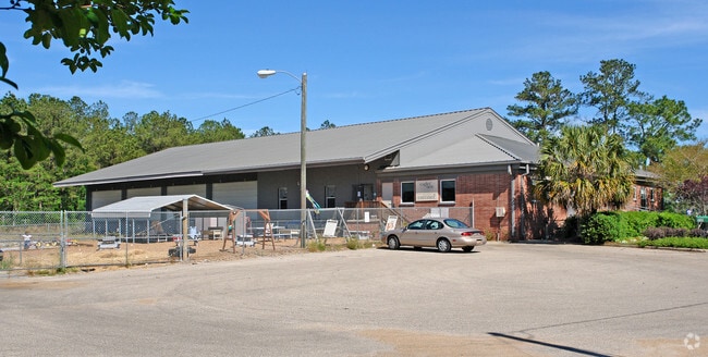
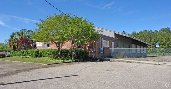
Property Record
850 Appleyard Dr, Tallahassee, FL 32304

NEARBY LISTINGS FOR SALE OR LEASE
Property Detail
850 Appleyard Dr
Tallahassee, FL
Industrial Park
21-28-51-00B-004.0
INDUSTRIAL PARK 28 29 32 & 33 1N 1W LOTS 4 THRU 8 & E 1/2 OF 9 BLOCK B AND PART OF BLOCK H OR 950/2119 1300/990 1314/1282 1653/996 1893/1211 1502/2313 1607/1086 1722/1940 1893/1211 2192/1816
University
Leon
X
Florida
12073C0279F
4-8
0
14.13 AC
2025
West Tallahassee
002106
Tallahassee
11,260 SF
DEMOGRAPHICS near 850 Appleyard Dr
1 Mile
3 Mile
5 Mile
2024 Total Population
11,579
76,237
133,460
2029 Population
11,921
79,399
139,843
Pop Growth 2024-2029
+ 2.95%
+ 4.15%
+ 4.78%
Average Age
29
30
33
2024 Total Households
4,465
31,675
56,008
HH Growth 2024-2029
+ 2.42%
+ 4.15%
+ 4.95%
Median Household Inc
$32,129
$33,948
$41,335
Avg Household Size
2.20
2.20
2.20
2024 Avg HH Vehicles
2.00
2.00
2.00
Median Home Value
$141,079
$148,053
$183,131
Median Year Built
1989
1986
1982
Nearby Places
Map Layers
Map Styles
 Street
 Aerial
- Restaurants
- Banks
- Shops
- Fitness
- Groceries
PUBLIC TRANSPORTATION
AIRPORT
Tallahassee International
DRIVE
WALK
Distance
Tallahassee International
9 min
4.6 mi
Nearby Properties
Address
Land Use
TOTAL SIZE
Lot Size
Zoning
Address
Land Use
TOTAL SIZE
Lot Size
Zoning
1,635,322 SF
29.76 AC
UT
Address
Land Use
TOTAL SIZE
Lot Size
Zoning
6,686,582 SF
86.50 AC
UT
Address
Land Use
TOTAL SIZE
Lot Size
Zoning
4,577,528 SF
108.47 AC
UT
Address
Land Use
TOTAL SIZE
Lot Size
Zoning
3,647,358 SF
49.17 AC
UT
Address
Land Use
TOTAL SIZE
Lot Size
Zoning
1,604,893 SF
175.71 AC
MR1
Address
Land Use
TOTAL SIZE
Lot Size
Zoning
859,455 SF
3.79 AC
CU45
Address
Land Use
TOTAL SIZE
Lot Size
Zoning
704,857 SF
4.95 AC
UT
Address
Land Use
TOTAL SIZE
Lot Size
Zoning
959,505 SF
32.03 AC
M1
Address
Land Use
TOTAL SIZE
Lot Size
Zoning
664,514 SF
2.49 AC
UT
Address
Land Use
TOTAL SIZE
Lot Size
Zoning
369,383 SF
4.51 AC
UT
Address
Land Use
TOTAL SIZE
Lot Size
Zoning
758,762 SF
20.82 AC
UT
Address
Land Use
TOTAL SIZE
Lot Size
Zoning
452,530 SF
10.30 AC
UV
Address
Land Use
TOTAL SIZE
Lot Size
Zoning
719,149 SF
40.73 AC
MR1
Address
Land Use
TOTAL SIZE
Lot Size
Zoning
445,676 SF
23.50 AC
PUD
Address
Land Use
TOTAL SIZE
Lot Size
Zoning
652,729 SF
1.71 AC
UT
Address
Land Use
TOTAL SIZE
Lot Size
Zoning
721,205 SF
6.19 AC
UT
Address
Land Use
TOTAL SIZE
Lot Size
Zoning
414,216 SF
2.23 AC
CU45
Address
Land Use
TOTAL SIZE
Lot Size
Zoning
556,751 SF
20.60 AC
CP
Address
Land Use
TOTAL SIZE
Lot Size
Zoning
859,666 SF
20.17 AC
MR1
Address
Land Use
TOTAL SIZE
Lot Size
Zoning
479,705 SF
9.24 AC
UT
Address
Land Use
TOTAL SIZE
Lot Size
Zoning
538,290 SF
11.05 AC
Address
Land Use
TOTAL SIZE
Lot Size
Zoning
851,869 SF
5.15 AC
DI
Address
Land Use
TOTAL SIZE
Lot Size
Zoning
485,685 SF
2.82 AC
UV
Address
Land Use
TOTAL SIZE
Lot Size
Zoning
392,437 SF
10 AC
UT
Address
Land Use
TOTAL SIZE
Lot Size
Zoning
222,994 SF
2.52 AC
UV
Address
Land Use
TOTAL SIZE
Lot Size
Zoning
225,370 SF
3.76 AC
CU45
Address
Land Use
TOTAL SIZE
Lot Size
Zoning
181,104 SF
1.78 AC
UV
Address
Land Use
TOTAL SIZE
Lot Size
Zoning
604,638 SF
2.26 AC
Address
Land Use
TOTAL SIZE
Lot Size
Zoning
459,568 SF
10.10 AC
CU45
Address
Land Use
TOTAL SIZE
Lot Size
Zoning
424,591 SF
2.77 AC
UT
The World's #1 Commercial Real Estate Marketplace
Connect with us
© 2026 CoStar Group
The information above has been obtained from sources believed reliable. While we do not doubt its accuracy we have not verified it and make no guarantee, warranty or representation about it. It is your responsibility to independently confirm its accuracy and completeness. Any projections, opinions, assumptions, or estimates used are for example only and do not represent the current or future performance of the property. The value of this transaction to you depends on tax and other factors which should be evaluated by your tax, financial, and legal advisors. You and your advisors should conduct a careful, independent investigation of the property to determine to your satisfaction the suitability of the property for your needs.