Property Record
850 S Buncombe Rd, Greer, SC 29650

Property Detail
850 S Buncombe Rd
Greenville-Anderson-Greer, SC
MAP 0535.01; 2
0535.01-01-032.04
Greenville
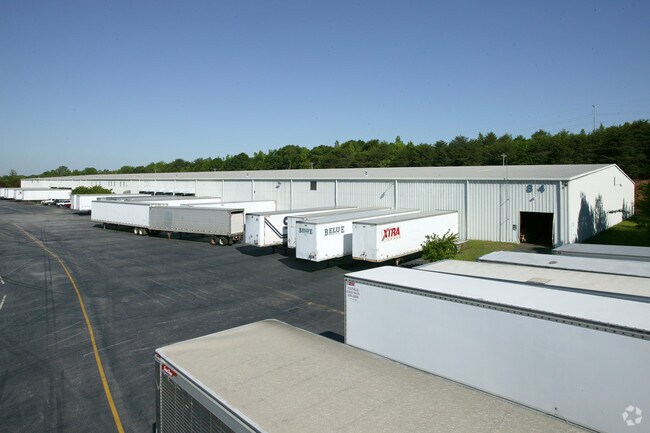
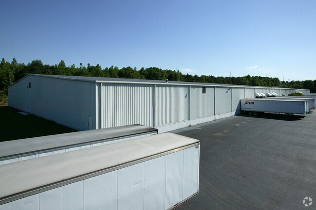
Truckterminal
South Carolina
OD
032.04
B and X Area of moderate flood hazard, usually the area between the limits of the 100-year and 500-year floods.
3.56 AC
2025
Rt 14 Corridor
2025
Greenville/Spartanburg
002503
NEARBY LISTINGS FOR SALE OR LEASE
DEMOGRAPHICS near 850 S Buncombe Rd
1 mile
3 mile
5 mile
2025 Total Population
6,465
48,557
110,286
2030 Population
6,948
52,446
119,168
Pop Growth 2025-2030
+ 7.47%
+ 8.01%
+ 8.05%
Average Age
40
39
40
2025 Total Households
2,628
19,118
43,717
HH Growth 2025-2030
+ 7.65%
+ 8.21%
+ 8.23%
Median Household Inc
$92,636
$80,632
$80,266
Avg Household Size
2.40
2.50
2.50
2025 Avg HH Vehicles
2.00
2.00
2.00
Median Home Value
$311,628
$309,663
$307,459
Median Year Built
2003
1993
1991
Nearby Places
Map Layers
Map Styles
 Street
 Aerial
Layers
 Traffic
 Biking
Places
Listings with unknown addresses are not visible on the map
- Restaurants
- Banks
- Shops
- Fitness
- Groceries
PUBLIC TRANSPORTATION
AIRPORT
Greenville Spartanburg International
Drive
Walk
Distance
Greenville Spartanburg International
13 min
4.8 mi
Freight Ports
North Charleston Terminal
Drive
Walk
Distance
North Charleston Terminal
236 min
206.6 mi
Nearby Properties
Address
Land Use
TOTAL SIZE
Lot Size
Zoning
Address
Land Use
TOTAL SIZE
Lot Size
Zoning
136.04 AC
I1
Address
Land Use
TOTAL SIZE
Lot Size
Zoning
88.98 AC
RS
Address
Land Use
TOTAL SIZE
Lot Size
Zoning
14.20 AC
UNZONED
Address
Land Use
TOTAL SIZE
Lot Size
Zoning
532 SF
72.61 AC
I1
Address
Land Use
TOTAL SIZE
Lot Size
Zoning
13.25 AC
I1
Address
Land Use
TOTAL SIZE
Lot Size
Zoning
5.07 AC
C2
Address
Land Use
TOTAL SIZE
Lot Size
Zoning
8.30 AC
RM
Address
Land Use
TOTAL SIZE
Lot Size
Zoning
0.42 AC
OD
Address
Land Use
TOTAL SIZE
Lot Size
Zoning
99.01 AC
I1
Address
Land Use
TOTAL SIZE
Lot Size
Zoning
14.33 AC
I1
Address
Land Use
TOTAL SIZE
Lot Size
Zoning
48.84 AC
C2
Address
Land Use
TOTAL SIZE
Lot Size
Zoning
11.80 AC
R10
Address
Land Use
TOTAL SIZE
Lot Size
Zoning
11.30 AC
R10
Address
Land Use
TOTAL SIZE
Lot Size
Zoning
9.50 AC
I1
Address
Land Use
TOTAL SIZE
Lot Size
Zoning
8.22 AC
I1
Address
Land Use
TOTAL SIZE
Lot Size
Zoning
143.57 AC
I1
Address
Land Use
TOTAL SIZE
Lot Size
Zoning
1.05 AC
S1
Address
Land Use
TOTAL SIZE
Lot Size
Zoning
5.20 AC
TI1
Address
Land Use
TOTAL SIZE
Lot Size
Zoning
6.81 AC
RM
Address
Land Use
TOTAL SIZE
Lot Size
Zoning
1.90 AC
I1
Address
Land Use
TOTAL SIZE
Lot Size
Zoning
92.74 AC
R15
Address
Land Use
TOTAL SIZE
Lot Size
Zoning
10.20 AC
S1
Address
Land Use
TOTAL SIZE
Lot Size
Zoning
25.70 AC
R20
Address
Land Use
TOTAL SIZE
Lot Size
Zoning
5.23 AC
I1
Address
Land Use
TOTAL SIZE
Lot Size
Zoning
5.15 AC
R15
Address
Land Use
TOTAL SIZE
Lot Size
Zoning
15.90 AC
TS1
Address
Land Use
TOTAL SIZE
Lot Size
Zoning
12.91 AC
RM
Address
Land Use
TOTAL SIZE
Lot Size
Zoning
11.70 AC
C2
Address
Land Use
TOTAL SIZE
Lot Size
Zoning
2.15 AC
C2
Address
Land Use
TOTAL SIZE
Lot Size
Zoning
0.51 AC
C1
The World's #1 Commercial Real Estate Marketplace
Connect with us
© 2026 CoStar Group
The information above has been obtained from sources believed reliable. While we do not doubt its accuracy we have not verified it and make no guarantee, warranty or representation about it. It is your responsibility to independently confirm its accuracy and completeness. Any projections, opinions, assumptions, or estimates used are for example only and do not represent the current or future performance of the property. The value of this transaction to you depends on tax and other factors which should be evaluated by your tax, financial, and legal advisors. You and your advisors should conduct a careful, independent investigation of the property to determine to your satisfaction the suitability of the property for your needs.