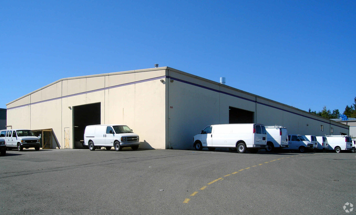
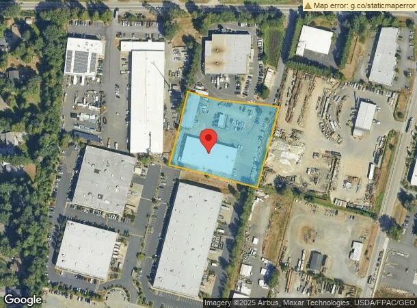
Property Record
8510 Maltby Rd, Woodinville, WA 98072
NEARBY LISTINGS FOR SALE OR LEASE
Property Detail
8510 Maltby Rd
Seattle-Tacoma-Bellevue, WA
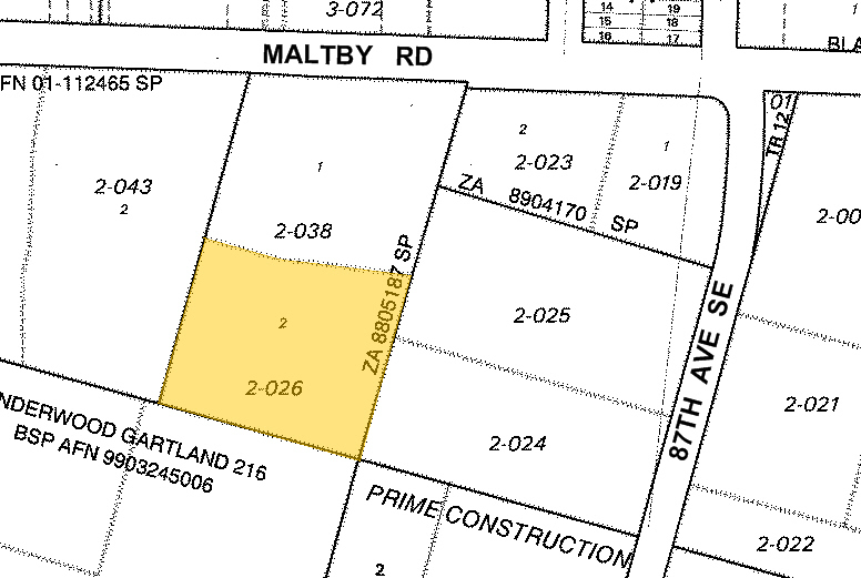
Snohomish County Short Plat #Za8805187sp
270525-002-026-00
SECTION 25 TOWNSHIP 27 RANGE 05 QUARTER NW - LOT 2 OF ZA8805187SP REC AFN 8903290047 & AMD AFFD OF CORR REC AFN 8904070320 BEING A PTN OF NW1/4 NW1/4
Industrialgeneral
Snohomish
X
Washington
53033C0090G
2
2024
2.41 AC
2025
Woodinville
051912
Seattle/Puget Sound
29,938 SF
DEMOGRAPHICS near 8510 Maltby Rd
1 Mile
3 Mile
5 Mile
2024 Total Population
2,097
24,990
132,929
2029 Population
2,165
25,786
136,992
Pop Growth 2024-2029
+ 3.24%
+ 3.19%
+ 3.06%
Average Age
43
40
38
2024 Total Households
732
8,322
47,561
HH Growth 2024-2029
+ 3.42%
+ 3.20%
+ 3.03%
Median Household Inc
$172,275
$173,844
$143,831
Avg Household Size
2.80
2.90
2.70
2024 Avg HH Vehicles
3.00
3.00
2.00
Median Home Value
$890,971
$858,185
$800,997
Median Year Built
1985
1987
1993
Nearby Places
- Restaurants
- Banks
- Shops
- Fitness
- Groceries
PUBLIC TRANSPORTATION
AIRPORT
Seattle Paine Field International
DRIVE
WALK
Distance
Seattle Paine Field International
30 min
14.3 mi
Seattle-Tacoma International
DRIVE
WALK
Distance
Seattle-Tacoma International
46 min
33.0 mi
Freight Ports
Port of Everett
DRIVE
WALK
Distance
Port of Everett
30 min
18.6 mi
Nearby Properties
Address
Land Use
TOTAL SIZE
Lot Size
Zoning
Address
Land Use
TOTAL SIZE
Lot Size
Zoning
270,101 SF
78.77 AC
LI
Address
Land Use
TOTAL SIZE
Lot Size
Zoning
229,632 SF
37.61 AC
P/I
Address
Land Use
TOTAL SIZE
Lot Size
Zoning
275,500 SF
16.29 AC
LI
Address
Land Use
TOTAL SIZE
Lot Size
Zoning
86,321 SF
32.88 AC
IP
Address
Land Use
TOTAL SIZE
Lot Size
Zoning
21,814 SF
8.36 AC
I
Address
Land Use
TOTAL SIZE
Lot Size
Zoning
95,522 SF
4.64 AC
LI
Address
Land Use
TOTAL SIZE
Lot Size
Zoning
81,736 SF
19.19 AC
R-5
Address
Land Use
TOTAL SIZE
Lot Size
Zoning
104,881 SF
9.96 AC
IP
Address
Land Use
TOTAL SIZE
Lot Size
Zoning
105,888 SF
5.63 AC
LI
Address
Land Use
TOTAL SIZE
Lot Size
Zoning
85,086 SF
4.42 AC
LI
Address
Land Use
TOTAL SIZE
Lot Size
Zoning
96,274 SF
5 AC
LI
Address
Land Use
TOTAL SIZE
Lot Size
Zoning
82,300 SF
4.76 AC
I
Address
Land Use
TOTAL SIZE
Lot Size
Zoning
105,707 SF
6.24 AC
LI
Address
Land Use
TOTAL SIZE
Lot Size
Zoning
96,137 SF
5.14 AC
I
Address
Land Use
TOTAL SIZE
Lot Size
Zoning
53,044 SF
11.32 AC
LI
Address
Land Use
TOTAL SIZE
Lot Size
Zoning
17,160 SF
33.55 AC
P/I
Address
Land Use
TOTAL SIZE
Lot Size
Zoning
79,032 SF
4.37 AC
I
Address
Land Use
TOTAL SIZE
Lot Size
Zoning
148,582 SF
9.83 AC
HI
Address
Land Use
TOTAL SIZE
Lot Size
Zoning
86,804 SF
1.16 AC
O
Address
Land Use
TOTAL SIZE
Lot Size
Zoning
66,962 SF
2.63 AC
I
Address
Land Use
TOTAL SIZE
Lot Size
Zoning
66,790 SF
4.87 AC
LI
Address
Land Use
TOTAL SIZE
Lot Size
Zoning
71,750 SF
4.81 AC
LI
Address
Land Use
TOTAL SIZE
Lot Size
Zoning
2,328 SF
15.42 AC
IP
Address
Land Use
TOTAL SIZE
Lot Size
Zoning
102,898 SF
6.23 AC
LI
Address
Land Use
TOTAL SIZE
Lot Size
Zoning
56,554 SF
1.94 AC
I
Address
Land Use
TOTAL SIZE
Lot Size
Zoning
62,857 SF
4.02 AC
IP
Address
Land Use
TOTAL SIZE
Lot Size
Zoning
52,460 SF
5.35 AC
IP
Address
Land Use
TOTAL SIZE
Lot Size
Zoning
76,645 SF
7.66 AC
CRC
Address
Land Use
TOTAL SIZE
Lot Size
Zoning
18.25 AC
PCB
The World's #1 Commercial Real Estate Marketplace
Connect with us
© 2025 CoStar Group
The information above has been obtained from sources believed reliable. While we do not doubt its accuracy we have not verified it and make no guarantee, warranty or representation about it. It is your responsibility to independently confirm its accuracy and completeness. Any projections, opinions, assumptions, or estimates used are for example only and do not represent the current or future performance of the property. The value of this transaction to you depends on tax and other factors which should be evaluated by your tax, financial, and legal advisors. You and your advisors should conduct a careful, independent investigation of the property to determine to your satisfaction the suitability of the property for your needs.