Property Record
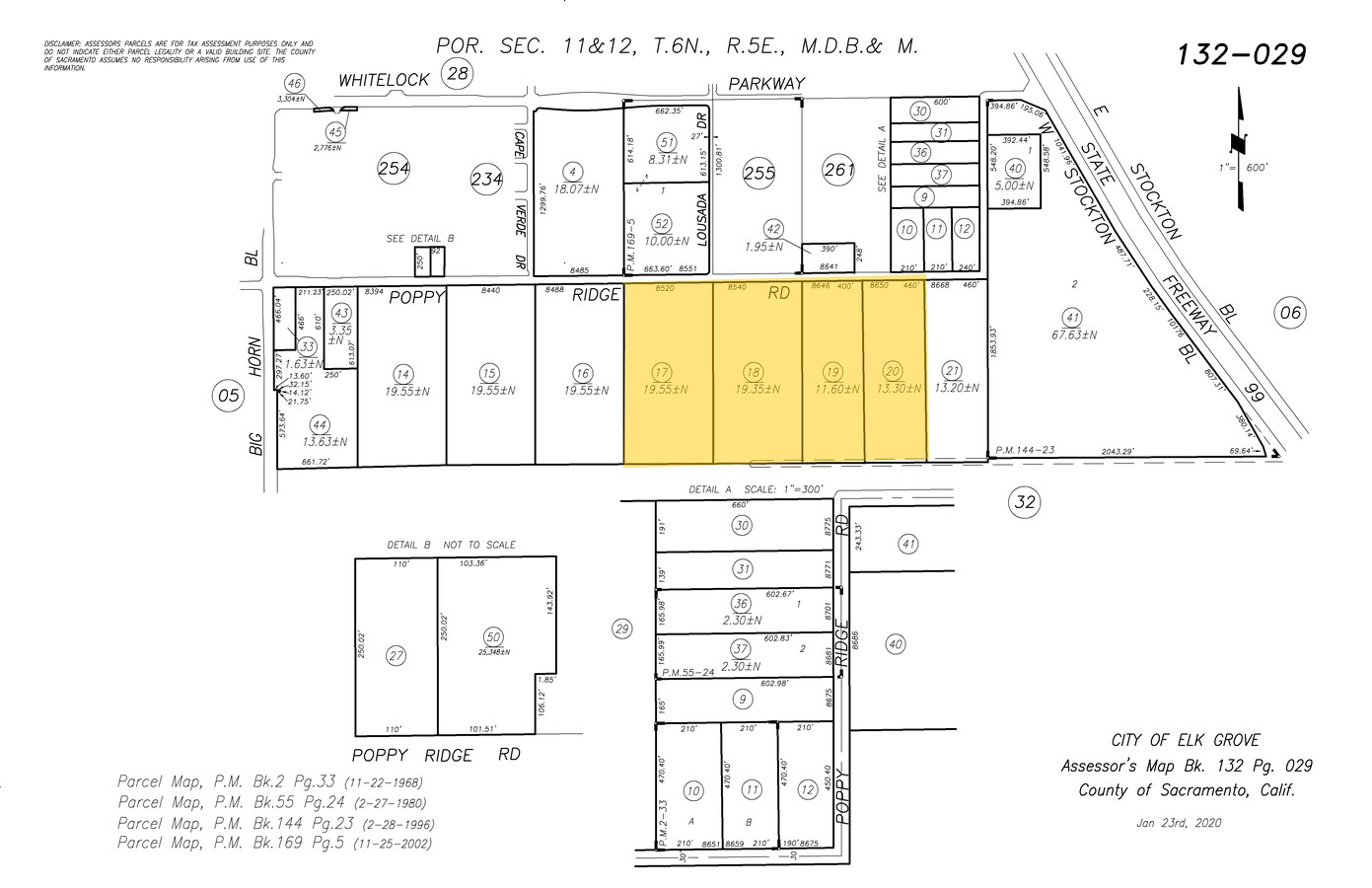
8520 Poppy Ridge Rd, Elk Grove, CA 95757
NEARBY LISTINGS FOR SALE OR LEASE
Property Detail
8520 Poppy Ridge Rd
132-0290-017
W 1/2 OF SW 1/4 OF NW 1/4 OF SEC 12 TWP 6 N R 5E, MDB&M CONTG 20 AC
Recreationalacreage
Sacramento
X
California
06067C0319H
19.55 AC
2023
Elk Grove
2024
Sacramento
009652
Sacramento--Roseville--Arden-Arcade, CA
1,652 SF
DEMOGRAPHICS near 8520 Poppy Ridge Rd
1 Mile
3 Mile
5 Mile
2024 Total Population
7,762
89,309
200,583
2029 Population
8,127
90,564
202,220
Pop Growth 2024-2029
+ 4.70%
+ 1.41%
+ 0.82%
Average Age
36
39
38
2024 Total Households
2,300
27,805
61,559
HH Growth 2024-2029
+ 4.96%
+ 1.35%
+ 0.78%
Median Household Inc
$138,421
$109,352
$106,516
Avg Household Size
3.40
3.10
3.20
2024 Avg HH Vehicles
2.00
2.00
2.00
Median Home Value
$684,635
$582,146
$537,089
Median Year Built
2011
2001
1999
Nearby Places
- Restaurants
- Banks
- Shops
- Fitness
- Groceries
PUBLIC TRANSPORTATION
AIRPORT
Sacramento International
DRIVE
WALK
Distance
Sacramento International
40 min
28.1 mi
Freight Ports
Port of Stockton
DRIVE
WALK
Distance
Port of Stockton
47 min
37.1 mi
Nearby Properties
Address
Land Use
TOTAL SIZE
Lot Size
Zoning
Address
Land Use
TOTAL SIZE
Lot Size
Zoning
43.54 AC
LI
Address
Land Use
TOTAL SIZE
Lot Size
Zoning
7.65 AC
RD-20
Address
Land Use
TOTAL SIZE
Lot Size
Zoning
4.98 AC
RD-20
Address
Land Use
TOTAL SIZE
Lot Size
Zoning
102,085 SF
10.26 AC
BP
Address
Land Use
TOTAL SIZE
Lot Size
Zoning
147,920 SF
18.20 AC
SC
Address
Land Use
TOTAL SIZE
Lot Size
Zoning
152,217 SF
17.42 AC
SC
Address
Land Use
TOTAL SIZE
Lot Size
Zoning
64,579 SF
5.41 AC
LRSPA
Address
Land Use
TOTAL SIZE
Lot Size
Zoning
105,511 SF
6.67 AC
BP
Address
Land Use
TOTAL SIZE
Lot Size
Zoning
105,511 SF
4.79 AC
BP
Address
Land Use
TOTAL SIZE
Lot Size
Zoning
242,577 SF
0.10 AC
RD-20
Address
Land Use
TOTAL SIZE
Lot Size
Zoning
111,489 SF
4.96 AC
MP
Address
Land Use
TOTAL SIZE
Lot Size
Zoning
195,101 SF
12.21 AC
BP
Address
Land Use
TOTAL SIZE
Lot Size
Zoning
76,090 SF
3.32 AC
RD-25
Address
Land Use
TOTAL SIZE
Lot Size
Zoning
108,843 SF
4.14 AC
RD-30
Address
Land Use
TOTAL SIZE
Lot Size
Zoning
185,300 SF
11.63 AC
RD-20
Address
Land Use
TOTAL SIZE
Lot Size
Zoning
3.88 AC
RD-20
Address
Land Use
TOTAL SIZE
Lot Size
Zoning
221,954 SF
7.71 AC
RD-15
Address
Land Use
TOTAL SIZE
Lot Size
Zoning
4.88 AC
RD-25
Address
Land Use
TOTAL SIZE
Lot Size
Zoning
91,226 SF
10.81 AC
SC
Address
Land Use
TOTAL SIZE
Lot Size
Zoning
221,556 SF
20.10 AC
HI
Address
Land Use
TOTAL SIZE
Lot Size
Zoning
83,274 SF
9.14 AC
SC
Address
Land Use
TOTAL SIZE
Lot Size
Zoning
110,372 SF
2.68 AC
BP
Address
Land Use
TOTAL SIZE
Lot Size
Zoning
102,526 SF
4.06 AC
MP
Address
Land Use
TOTAL SIZE
Lot Size
Zoning
65,148 SF
5.77 AC
GC
Address
Land Use
TOTAL SIZE
Lot Size
Zoning
100 SF
50.85 AC
LRSPA
Address
Land Use
TOTAL SIZE
Lot Size
Zoning
42,890 SF
4.38 AC
MP
Address
Land Use
TOTAL SIZE
Lot Size
Zoning
88,408 SF
9.41 AC
SC
Address
Land Use
TOTAL SIZE
Lot Size
Zoning
66,793 SF
2.48 AC
SC
Address
Land Use
TOTAL SIZE
Lot Size
Zoning
68,190 SF
3.75 AC
BP
Address
Land Use
TOTAL SIZE
Lot Size
Zoning
68,217 SF
8.95 AC
RD-20
The World's #1 Commercial Real Estate Marketplace
Connect with us
© 2025 CoStar Group
The information above has been obtained from sources believed reliable. While we do not doubt its accuracy we have not verified it and make no guarantee, warranty or representation about it. It is your responsibility to independently confirm its accuracy and completeness. Any projections, opinions, assumptions, or estimates used are for example only and do not represent the current or future performance of the property. The value of this transaction to you depends on tax and other factors which should be evaluated by your tax, financial, and legal advisors. You and your advisors should conduct a careful, independent investigation of the property to determine to your satisfaction the suitability of the property for your needs.