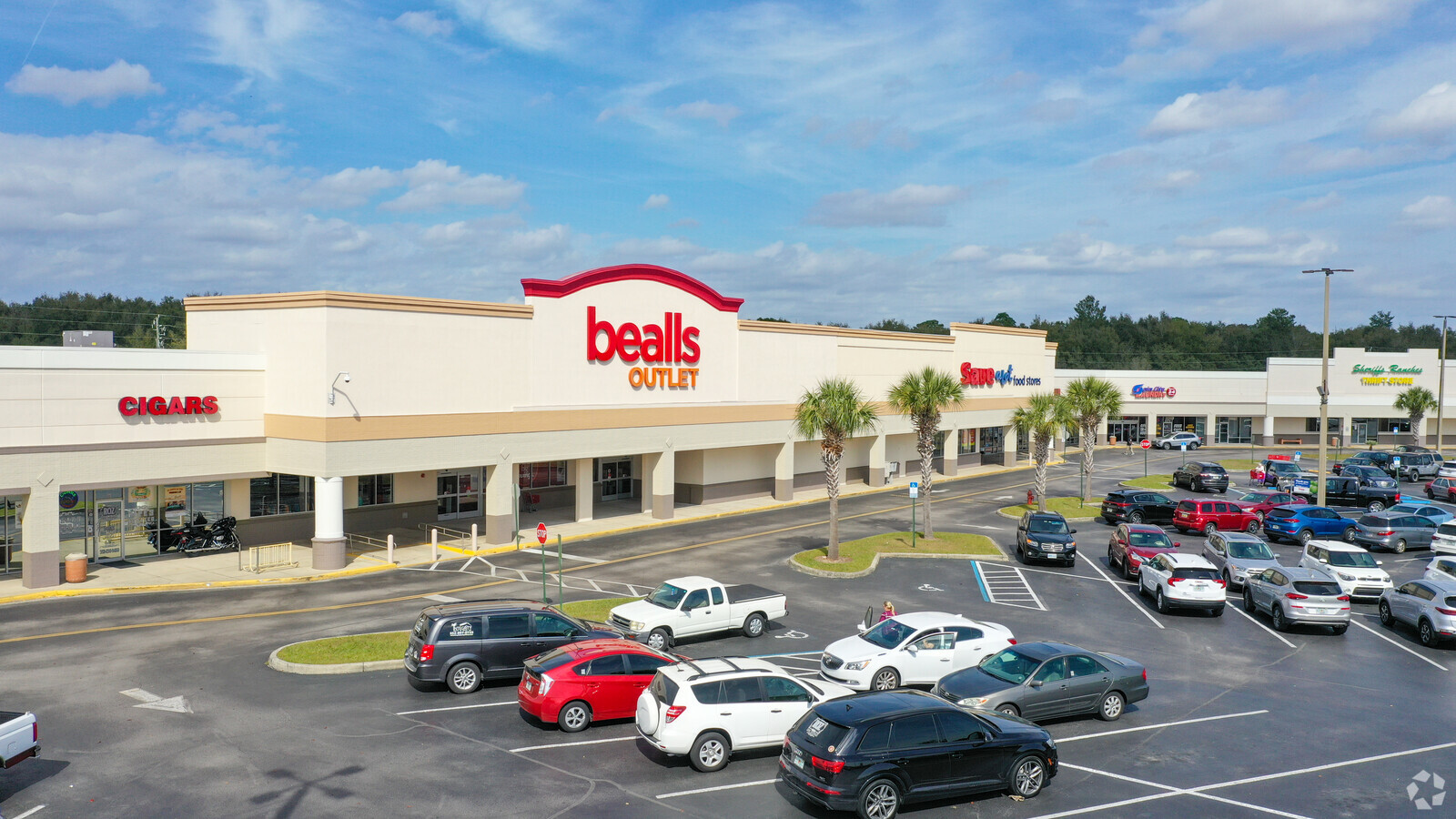
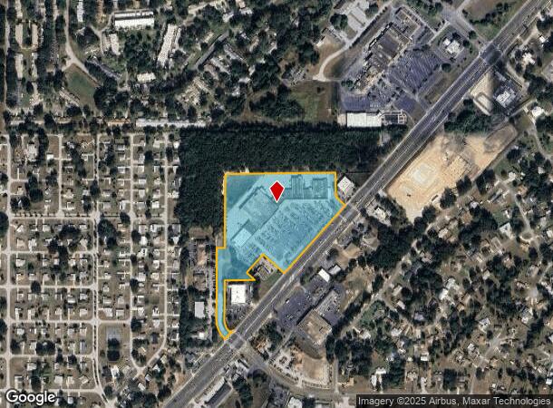
Property Record
8585 Sw Highway 200 Rd, Ocala, FL 34481
NEARBY LISTINGS FOR SALE OR LEASE
Property Detail
8585 Sw Highway 200 Rd
Ocala, FL
Steeplechase
35014-000-00
SEC 25 TWP 16 RGE 20 PLAT BOOK 002 PAGE 078 STEEPLECHASE LOT 2 & COM AT THE N 1/4 COR OF SEC 25 TH N 88-47-30 E 372.11 FT TH S 41-34-12 W 423.25 FT TH S 88-54-30 W 1095.99 FT TO THE POC OF A CURVE CONCAVE SELY A CENTRAL ANGLE OF 89-09-04 A RADIUS OF
Regionalshoppingcenterormallwithanchorstore
Marion
AE
Florida
12083C0684E
2
2023
13.41 AC
2023
Outlying Marion County
002610
Ocala
110,391 SF
DEMOGRAPHICS near 8585 Sw Highway 200 Rd
1 Mile
3 Mile
5 Mile
2024 Total Population
6,196
29,803
54,173
2029 Population
7,006
33,771
61,646
Pop Growth 2024-2029
+ 13.07%
+ 13.31%
+ 13.79%
Average Age
67
65
57
2024 Total Households
3,613
15,975
25,915
HH Growth 2024-2029
+ 13.06%
+ 13.22%
+ 13.61%
Median Household Inc
$47,836
$53,669
$58,981
Avg Household Size
1.70
1.80
2.10
2024 Avg HH Vehicles
1.00
1.00
2.00
Median Home Value
$148,935
$185,936
$203,046
Median Year Built
1989
1996
1999
Nearby Places
- Restaurants
- Banks
- Shops
- Fitness
- Groceries
SALE & LEASE HISTORY
LISTING DATE
SALE/LEASE

Sep 25, 2016
For Lease
Oct 01, 2020
For Lease
Jun 30, 2017
For Sale
Nearby Properties
Address
Land Use
TOTAL SIZE
Lot Size
Zoning
Address
Land Use
TOTAL SIZE
Lot Size
Zoning
62,253 SF
6.52 AC
PUD
Address
Land Use
TOTAL SIZE
Lot Size
Zoning
96,094 SF
13.66 AC
B2
Address
Land Use
TOTAL SIZE
Lot Size
Zoning
74,928 SF
7.80 AC
PUD
Address
Land Use
TOTAL SIZE
Lot Size
Zoning
203,356 SF
27.08 AC
B4
Address
Land Use
TOTAL SIZE
Lot Size
Zoning
28,813 SF
70.30 AC
B4
Address
Land Use
TOTAL SIZE
Lot Size
Zoning
18,035 SF
3.33 AC
B2
Address
Land Use
TOTAL SIZE
Lot Size
Zoning
88,777 SF
10.50 AC
B4
Address
Land Use
TOTAL SIZE
Lot Size
Zoning
139,728 SF
22.86 AC
B4
Address
Land Use
TOTAL SIZE
Lot Size
Zoning
43,619 SF
6.04 AC
R3
Address
Land Use
TOTAL SIZE
Lot Size
Zoning
7,677 SF
26.27 AC
B2
Address
Land Use
TOTAL SIZE
Lot Size
Zoning
98,205 SF
13.41 AC
B2
Address
Land Use
TOTAL SIZE
Lot Size
Zoning
65,060 SF
11.90 AC
B2
Address
Land Use
TOTAL SIZE
Lot Size
Zoning
69,278 SF
7.52 AC
B4
Address
Land Use
TOTAL SIZE
Lot Size
Zoning
42,159 SF
5.95 AC
B2
Address
Land Use
TOTAL SIZE
Lot Size
Zoning
58,381 SF
5.12 AC
R3
Address
Land Use
TOTAL SIZE
Lot Size
Zoning
68,180 SF
5.40 AC
B5
Address
Land Use
TOTAL SIZE
Lot Size
Zoning
27,563 SF
3.03 AC
B4
Address
Land Use
TOTAL SIZE
Lot Size
Zoning
47,378 SF
23.26 AC
A1
Address
Land Use
TOTAL SIZE
Lot Size
Zoning
16,214 SF
4.91 AC
B2
Address
Land Use
TOTAL SIZE
Lot Size
Zoning
286.80 AC
PUD
Address
Land Use
TOTAL SIZE
Lot Size
Zoning
27,862 SF
17.04 AC
A1
Address
Land Use
TOTAL SIZE
Lot Size
Zoning
37,213 SF
14.54 AC
A1
Address
Land Use
TOTAL SIZE
Lot Size
Zoning
41,642 SF
5.47 AC
B4
Address
Land Use
TOTAL SIZE
Lot Size
Zoning
17,428 SF
2.01 AC
B4
Address
Land Use
TOTAL SIZE
Lot Size
Zoning
20,288 SF
7.20 AC
B2
Address
Land Use
TOTAL SIZE
Lot Size
Zoning
45,364 SF
6.69 AC
B2
Address
Land Use
TOTAL SIZE
Lot Size
Zoning
16,308 SF
1.74 AC
B2
Address
Land Use
TOTAL SIZE
Lot Size
Zoning
21,753 SF
2.73 AC
PUD
Address
Land Use
TOTAL SIZE
Lot Size
Zoning
955 AC
A1
The World's #1 Commercial Real Estate Marketplace
Connect with us
© 2025 CoStar Group
The information above has been obtained from sources believed reliable. While we do not doubt its accuracy we have not verified it and make no guarantee, warranty or representation about it. It is your responsibility to independently confirm its accuracy and completeness. Any projections, opinions, assumptions, or estimates used are for example only and do not represent the current or future performance of the property. The value of this transaction to you depends on tax and other factors which should be evaluated by your tax, financial, and legal advisors. You and your advisors should conduct a careful, independent investigation of the property to determine to your satisfaction the suitability of the property for your needs.