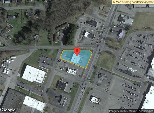
Property Record
867 State Route 13, Cortland, NY 13045

Current Lease Availabilities
NEARBY LISTINGS FOR SALE OR LEASE
Property Detail
867 State Route 13
112289-095-000-0010-004-100-0000
Cortland
Storebuilding
New York
X
4.100
36023C0229D
1.33 AC
2024
Cortland County
2023
Syracuse
971000
Cortland, NY
10,058 SF
DEMOGRAPHICS near 867 State Route 13
1 Mile
3 Mile
5 Mile
2024 Total Population
1,669
18,828
29,867
2029 Population
1,642
18,668
29,268
Pop Growth 2024-2029
(1.62%)
(0.85%)
(2.01%)
Average Age
42
38
39
2024 Total Households
660
7,020
11,610
HH Growth 2024-2029
(1.82%)
(0.84%)
(2.20%)
Median Household Inc
$63,594
$60,374
$58,586
Avg Household Size
2.10
2.10
2.20
2024 Avg HH Vehicles
2.00
2.00
2.00
Median Home Value
$147,906
$150,049
$148,687
Median Year Built
1967
1953
1954
Nearby Places
- Restaurants
- Banks
- Shops
- Fitness
- Groceries
PUBLIC TRANSPORTATION
AIRPORT
Ithaca Tompkins International
DRIVE
WALK
Distance
Ithaca Tompkins International
26 min
16.8 mi
Freight Ports
Albany, NY Port
DRIVE
WALK
Distance
Albany, NY Port
204 min
157.7 mi
Nearby Properties
Address
Land Use
TOTAL SIZE
Lot Size
Zoning
Address
Land Use
TOTAL SIZE
Lot Size
Zoning
224,991 SF
6.70 AC
05 - COMME
Address
Land Use
TOTAL SIZE
Lot Size
Zoning
17,080 SF
74.40 AC
05 - COMME
Address
Land Use
TOTAL SIZE
Lot Size
Zoning
221,453 SF
27.71 AC
B1
Address
Land Use
TOTAL SIZE
Lot Size
Zoning
162,556 SF
22.70 AC
05 - COMME
Address
Land Use
TOTAL SIZE
Lot Size
Zoning
39,737 SF
4.88 AC
05 - COMME
Address
Land Use
TOTAL SIZE
Lot Size
Zoning
138,432 SF
1.01 AC
08 - GOVER
Address
Land Use
TOTAL SIZE
Lot Size
Zoning
56,160 SF
4.60 AC
08 - GOVER
Address
Land Use
TOTAL SIZE
Lot Size
Zoning
111,968 SF
2.80 AC
08 - GOVER
Address
Land Use
TOTAL SIZE
Lot Size
Zoning
99,000 SF
7.30 AC
08 - GOVER
Address
Land Use
TOTAL SIZE
Lot Size
Zoning
189,440 SF
20.62 AC
05 - COMME
Address
Land Use
TOTAL SIZE
Lot Size
Zoning
107,712 SF
4.77 AC
05 - COMME
Address
Land Use
TOTAL SIZE
Lot Size
Zoning
30,606 SF
78.50 AC
IN
Address
Land Use
TOTAL SIZE
Lot Size
Zoning
111,240 SF
13.41 AC
05 - COMME
Address
Land Use
TOTAL SIZE
Lot Size
Zoning
85,324 SF
4 AC
08 - GOVER
Address
Land Use
TOTAL SIZE
Lot Size
Zoning
51,750 SF
15.10 AC
08 - GOVER
Address
Land Use
TOTAL SIZE
Lot Size
Zoning
42,508 SF
3.60 AC
08 - GOVER
Address
Land Use
TOTAL SIZE
Lot Size
Zoning
73,182 SF
2.60 AC
08 - GOVER
Address
Land Use
TOTAL SIZE
Lot Size
Zoning
72,536 SF
2 AC
08 - GOVER
Address
Land Use
TOTAL SIZE
Lot Size
Zoning
81,680 SF
05 - COMME
Address
Land Use
TOTAL SIZE
Lot Size
Zoning
96,605 SF
3.08 AC
05 - COMME
Address
Land Use
TOTAL SIZE
Lot Size
Zoning
39.20 AC
04 - FARM
Address
Land Use
TOTAL SIZE
Lot Size
Zoning
73,183 SF
4.78 AC
Address
Land Use
TOTAL SIZE
Lot Size
Zoning
4,592 SF
6.40 AC
05 - COMME
Address
Land Use
TOTAL SIZE
Lot Size
Zoning
109,070 SF
21.25 AC
05 - COMME
Address
Land Use
TOTAL SIZE
Lot Size
Zoning
74,712 SF
1.50 AC
05 - COMME
Address
Land Use
TOTAL SIZE
Lot Size
Zoning
33,520 SF
3.50 AC
08 - GOVER
Address
Land Use
TOTAL SIZE
Lot Size
Zoning
71,348 SF
5.90 AC
08 - GOVER
Address
Land Use
TOTAL SIZE
Lot Size
Zoning
18,960 SF
0.52 AC
08 - GOVER
Address
Land Use
TOTAL SIZE
Lot Size
Zoning
8,000 SF
118.30 AC
05 - COMME
The World's #1 Commercial Real Estate Marketplace
Connect with us
© 2025 CoStar Group
The information above has been obtained from sources believed reliable. While we do not doubt its accuracy we have not verified it and make no guarantee, warranty or representation about it. It is your responsibility to independently confirm its accuracy and completeness. Any projections, opinions, assumptions, or estimates used are for example only and do not represent the current or future performance of the property. The value of this transaction to you depends on tax and other factors which should be evaluated by your tax, financial, and legal advisors. You and your advisors should conduct a careful, independent investigation of the property to determine to your satisfaction the suitability of the property for your needs.