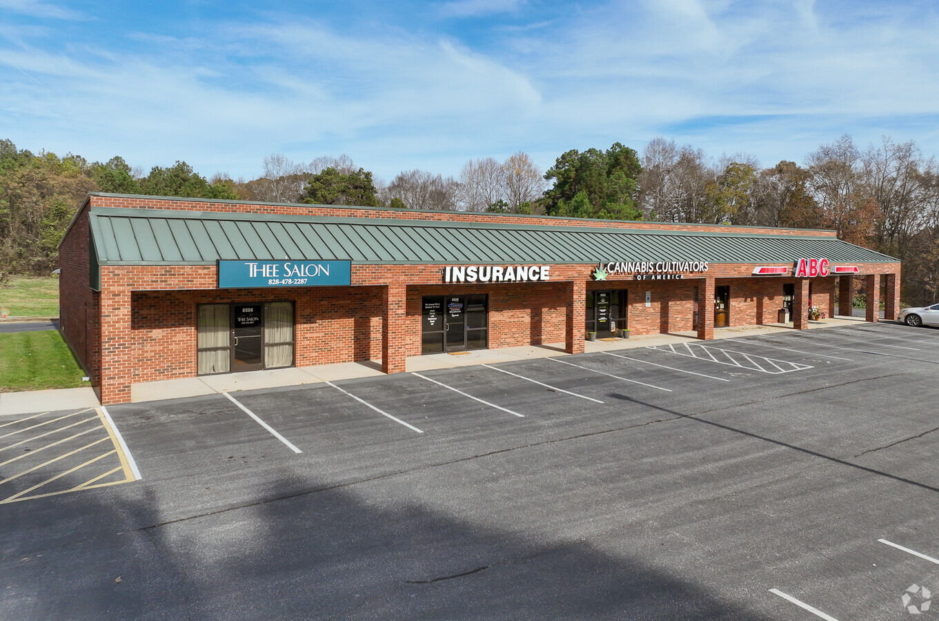
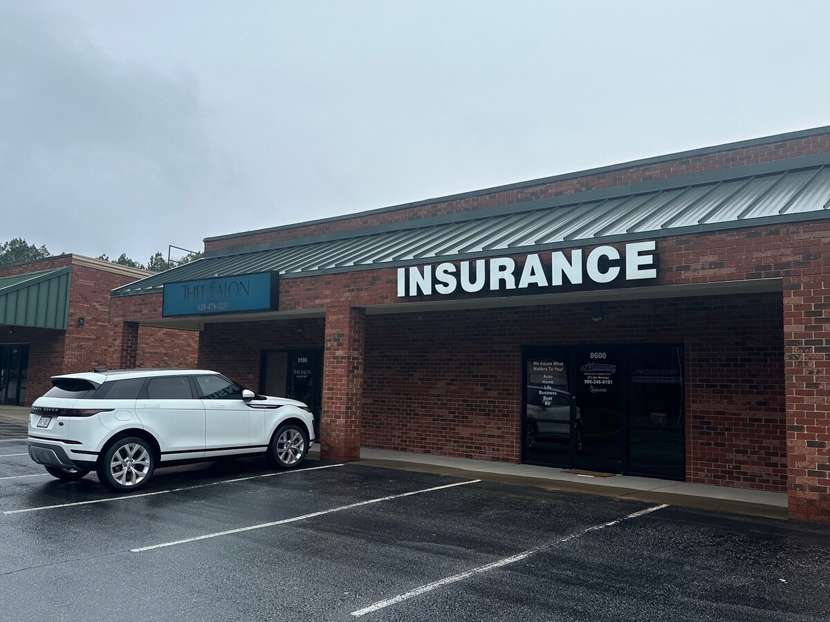
Property Record
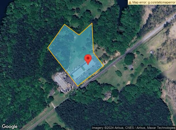
8584 Nc Highway 150 E, Terrell, NC 28682
NEARBY LISTINGS FOR SALE OR LEASE
Property Detail
8584 Nc Highway 150 E
4617088974200000
LOT 2 TR 2 PL52-79 HWY 150 EAST PL 52-79
Apartment
Catawba
X
North Carolina
3710461700K
2
2024
5.36 AC
2024
Catawba County
011503
Charlotte
6,375 SF
Hickory-Lenoir-Morganton, NC
DEMOGRAPHICS near 8584 Nc Highway 150 E
1 Mile
3 Mile
5 Mile
2024 Total Population
571
12,483
45,289
2029 Population
650
14,026
51,011
Pop Growth 2024-2029
+ 13.84%
+ 12.36%
+ 12.63%
Average Age
50
45
44
2024 Total Households
251
5,006
17,764
HH Growth 2024-2029
+ 13.94%
+ 12.23%
+ 12.50%
Median Household Inc
$111,684
$117,756
$115,545
Avg Household Size
2.30
2.50
2.50
2024 Avg HH Vehicles
2.00
2.00
2.00
Median Home Value
$480,468
$496,260
$489,582
Median Year Built
2006
2003
2003
Nearby Places
- Restaurants
- Banks
- Shops
- Fitness
- Groceries
PUBLIC TRANSPORTATION
AIRPORT
Charlotte Douglas International
DRIVE
WALK
Distance
Charlotte Douglas International
54 min
38.4 mi
Freight Ports
North Charleston Terminal
DRIVE
WALK
Distance
North Charleston Terminal
266 min
230.5 mi
SALE & LEASE HISTORY
LISTING DATE
SALE/LEASE

Sep 25, 2016
For Lease
Nov 08, 2019
For Lease
Mar 20, 2021
For Lease
Apr 13, 2023
For Lease
Nearby Properties
Address
Land Use
TOTAL SIZE
Lot Size
Zoning
Address
Land Use
TOTAL SIZE
Lot Size
Zoning
31,198 SF
26.01 AC
PD-CD
Address
Land Use
TOTAL SIZE
Lot Size
Zoning
4,516 SF
24.47 AC
CM
Address
Land Use
TOTAL SIZE
Lot Size
Zoning
95,320 SF
50.32 AC
RA
Address
Land Use
TOTAL SIZE
Lot Size
Zoning
1,288 SF
16.04 AC
PD-CD
Address
Land Use
TOTAL SIZE
Lot Size
Zoning
1,709.40 AC
GI
Address
Land Use
TOTAL SIZE
Lot Size
Zoning
684.59 AC
PD-CD
Address
Land Use
TOTAL SIZE
Lot Size
Zoning
60,860 SF
9.81 AC
PD-CD
Address
Land Use
TOTAL SIZE
Lot Size
Zoning
79,137 SF
6.34 AC
HC
Address
Land Use
TOTAL SIZE
Lot Size
Zoning
17.50 AC
R-20
Address
Land Use
TOTAL SIZE
Lot Size
Zoning
21,600 SF
10.79 AC
HB
Address
Land Use
TOTAL SIZE
Lot Size
Zoning
3,571 SF
606.06 AC
R-80
Address
Land Use
TOTAL SIZE
Lot Size
Zoning
1,008 SF
4.96 AC
HB
Address
Land Use
TOTAL SIZE
Lot Size
Zoning
32,142 SF
6.56 AC
CM
Address
Land Use
TOTAL SIZE
Lot Size
Zoning
18,316 SF
3.61 AC
PD-CD
Address
Land Use
TOTAL SIZE
Lot Size
Zoning
6,250 SF
16.57 AC
CMX
Address
Land Use
TOTAL SIZE
Lot Size
Zoning
37,999 SF
3.44 AC
HC
Address
Land Use
TOTAL SIZE
Lot Size
Zoning
6,889 SF
1.75 AC
PD-CD
Address
Land Use
TOTAL SIZE
Lot Size
Zoning
17,850 SF
4.19 AC
GB
Address
Land Use
TOTAL SIZE
Lot Size
Zoning
124.49 AC
GI
Address
Land Use
TOTAL SIZE
Lot Size
Zoning
20,595 SF
2.65 AC
PD-CD
Address
Land Use
TOTAL SIZE
Lot Size
Zoning
23,980 SF
4.68 AC
GB
Address
Land Use
TOTAL SIZE
Lot Size
Zoning
12,352 SF
4.55 AC
HC
Address
Land Use
TOTAL SIZE
Lot Size
Zoning
16,740 SF
3.35 AC
CM
Address
Land Use
TOTAL SIZE
Lot Size
Zoning
5,290 SF
1.21 AC
PD-CD
Address
Land Use
TOTAL SIZE
Lot Size
Zoning
5,210 SF
3.71 AC
GB
Address
Land Use
TOTAL SIZE
Lot Size
Zoning
8.04 AC
R-20
Address
Land Use
TOTAL SIZE
Lot Size
Zoning
2.50 AC
PD
Address
Land Use
TOTAL SIZE
Lot Size
Zoning
9,000 SF
6.04 AC
PD
Address
Land Use
TOTAL SIZE
Lot Size
Zoning
13,876 SF
3.74 AC
R-30
Address
Land Use
TOTAL SIZE
Lot Size
Zoning
12,717 SF
1.47 AC
PD-CD
The World's #1 Commercial Real Estate Marketplace
Connect with us
© 2025 CoStar Group
The information above has been obtained from sources believed reliable. While we do not doubt its accuracy we have not verified it and make no guarantee, warranty or representation about it. It is your responsibility to independently confirm its accuracy and completeness. Any projections, opinions, assumptions, or estimates used are for example only and do not represent the current or future performance of the property. The value of this transaction to you depends on tax and other factors which should be evaluated by your tax, financial, and legal advisors. You and your advisors should conduct a careful, independent investigation of the property to determine to your satisfaction the suitability of the property for your needs.