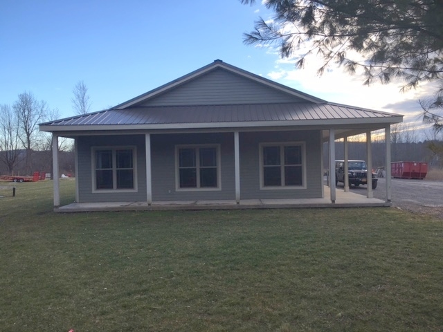
Property Record
8632 Cazenovia Rd, Manlius, NY 13104
NEARBY LISTINGS FOR SALE OR LEASE
Property Detail
8632 Cazenovia Rd
Syracuse, NY
FL 11 1084810
314600-005-000-0006-014-001-0000
Onondaga
Miscresidentialimprovement
New York
X
14.001
36067C0381F
7.13 AC
2024
SE Outer Onondaga County
2023
Syracuse
015702
DEMOGRAPHICS near 8632 Cazenovia Rd
1 Mile
3 Mile
5 Mile
2024 Total Population
562
10,484
24,130
2029 Population
545
10,288
23,589
Pop Growth 2024-2029
(3.02%)
(1.87%)
(2.24%)
Average Age
40
42
43
2024 Total Households
185
3,851
9,326
HH Growth 2024-2029
(3.24%)
(1.97%)
(2.42%)
Median Household Inc
$147,825
$119,562
$115,545
Avg Household Size
3.00
2.70
2.50
2024 Avg HH Vehicles
3.00
2.00
2.00
Median Home Value
$344,898
$316,555
$283,490
Median Year Built
1984
1982
1974
Nearby Places
- Restaurants
- Banks
- Shops
- Fitness
- Groceries
PUBLIC TRANSPORTATION
AIRPORT
Syracuse Hancock International
DRIVE
WALK
Distance
Syracuse Hancock International
34 min
21.1 mi
Freight Ports
Albany, NY Port
DRIVE
WALK
Distance
Albany, NY Port
172 min
138.5 mi
SALE & LEASE HISTORY
LISTING DATE
SALE/LEASE

Sep 23, 2016
For Sale
Apr 21, 2017
For Lease
Nearby Properties
Address
Land Use
TOTAL SIZE
Lot Size
Zoning
Address
Land Use
TOTAL SIZE
Lot Size
Zoning
293,638 SF
58.90 AC
R1
Address
Land Use
TOTAL SIZE
Lot Size
Zoning
219,526 SF
38.98 AC
RA
Address
Land Use
TOTAL SIZE
Lot Size
Zoning
15,240 SF
12.46 AC
R1
Address
Land Use
TOTAL SIZE
Lot Size
Zoning
26,508 SF
4.38 AC
C
Address
Land Use
TOTAL SIZE
Lot Size
Zoning
60,300 SF
3.70 AC
IND
Address
Land Use
TOTAL SIZE
Lot Size
Zoning
60,621 SF
5.63 AC
C1
Address
Land Use
TOTAL SIZE
Lot Size
Zoning
12,787 SF
1.52 AC
C
Address
Land Use
TOTAL SIZE
Lot Size
Zoning
28,037 SF
40.68 AC
C
Address
Land Use
TOTAL SIZE
Lot Size
Zoning
9,616 SF
6.40 AC
R5
Address
Land Use
TOTAL SIZE
Lot Size
Zoning
1,776 SF
14.74 AC
C
Address
Land Use
TOTAL SIZE
Lot Size
Zoning
56,580 SF
9.59 AC
IND
Address
Land Use
TOTAL SIZE
Lot Size
Zoning
15,186 SF
2.57 AC
RM
Address
Land Use
TOTAL SIZE
Lot Size
Zoning
12,851 SF
2.27 AC
C
Address
Land Use
TOTAL SIZE
Lot Size
Zoning
20,320 SF
1.01 AC
C1
Address
Land Use
TOTAL SIZE
Lot Size
Zoning
6,072 SF
2.15 AC
C
Address
Land Use
TOTAL SIZE
Lot Size
Zoning
13,984 SF
2.83 AC
R1
Address
Land Use
TOTAL SIZE
Lot Size
Zoning
112,978 SF
6.83 AC
IND
Address
Land Use
TOTAL SIZE
Lot Size
Zoning
14,416 SF
2.75 AC
IND
Address
Land Use
TOTAL SIZE
Lot Size
Zoning
17,616 SF
1.35 AC
R1
Address
Land Use
TOTAL SIZE
Lot Size
Zoning
42,220 SF
0.50 AC
C
Address
Land Use
TOTAL SIZE
Lot Size
Zoning
5,036 SF
2.49 AC
IND
Address
Land Use
TOTAL SIZE
Lot Size
Zoning
6,000 SF
57.89 AC
LW
Address
Land Use
TOTAL SIZE
Lot Size
Zoning
15,735 SF
2.83 AC
RA
Address
Land Use
TOTAL SIZE
Lot Size
Zoning
25,134 SF
2.79 AC
CA
Address
Land Use
TOTAL SIZE
Lot Size
Zoning
9,717 SF
0.90 AC
C
Address
Land Use
TOTAL SIZE
Lot Size
Zoning
13,708 SF
2.07 AC
CB
Address
Land Use
TOTAL SIZE
Lot Size
Zoning
9.04 AC
LW
Address
Land Use
TOTAL SIZE
Lot Size
Zoning
12,388 SF
1.01 AC
R2
Address
Land Use
TOTAL SIZE
Lot Size
Zoning
5,856 SF
0.14 AC
CB
Address
Land Use
TOTAL SIZE
Lot Size
Zoning
7,564 SF
0.97 AC
C
The World's #1 Commercial Real Estate Marketplace
Connect with us
© 2025 CoStar Group
The information above has been obtained from sources believed reliable. While we do not doubt its accuracy we have not verified it and make no guarantee, warranty or representation about it. It is your responsibility to independently confirm its accuracy and completeness. Any projections, opinions, assumptions, or estimates used are for example only and do not represent the current or future performance of the property. The value of this transaction to you depends on tax and other factors which should be evaluated by your tax, financial, and legal advisors. You and your advisors should conduct a careful, independent investigation of the property to determine to your satisfaction the suitability of the property for your needs.