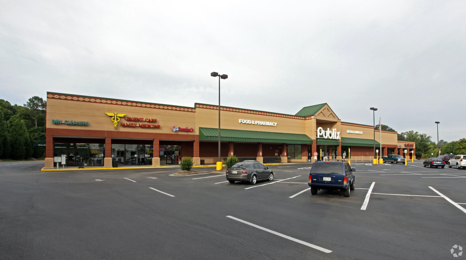
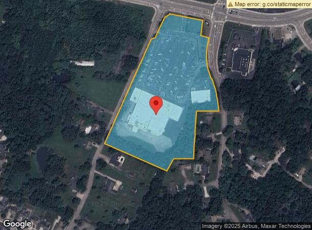
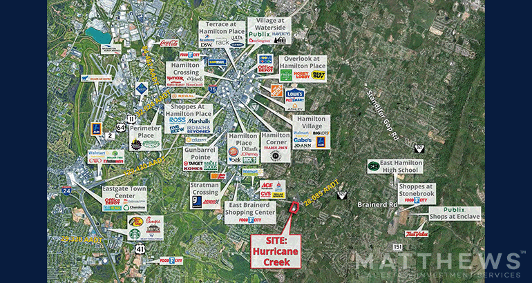
Property Record
8644 E Brainerd Rd, Chattanooga, TN 37421

NEARBY LISTINGS FOR SALE OR LEASE
Property Detail
8644 E Brainerd Rd
171B-C-014
Hurricane Creek Entrance Subdivision
Publicschool
SW 1/4 SEC 18 TWP 1 R-2
X
Hamilton
47065C0482G
Tennessee
2024
9.44 AC
2024
Outlying Chattanooga
011325
Chattanooga
66,065 SF
Chattanooga, TN-GA
DEMOGRAPHICS near 8644 E Brainerd Rd
1 Mile
3 Mile
5 Mile
2024 Total Population
6,166
41,328
88,374
2029 Population
6,500
43,743
93,627
Pop Growth 2024-2029
+ 5.42%
+ 5.84%
+ 5.94%
Average Age
41
42
41
2024 Total Households
2,282
16,196
34,660
HH Growth 2024-2029
+ 5.57%
+ 6.03%
+ 6.10%
Median Household Inc
$101,877
$91,815
$75,881
Avg Household Size
2.60
2.50
2.40
2024 Avg HH Vehicles
2.00
2.00
2.00
Median Home Value
$260,351
$274,935
$260,968
Median Year Built
1989
1993
1990
Nearby Places
- Restaurants
- Banks
- Shops
- Fitness
- Groceries
PUBLIC TRANSPORTATION
AIRPORT
Lovell Field
DRIVE
WALK
Distance
Lovell Field
15 min
6.3 mi
Freight Ports
Georgia Ports - Savannah
DRIVE
WALK
Distance
Georgia Ports - Savannah
407 min
357.7 mi
SALE & LEASE HISTORY
LISTING DATE
SALE/LEASE

Sep 25, 2016
For Lease
Oct 24, 2023
For Sale
Jun 14, 2024
For Sale
Nearby Properties
Address
Land Use
TOTAL SIZE
Lot Size
Zoning
Address
Land Use
TOTAL SIZE
Lot Size
Zoning
564,883 SF
27.46 AC
C2
Address
Land Use
TOTAL SIZE
Lot Size
Zoning
148,150 SF
23.87 AC
R4
Address
Land Use
TOTAL SIZE
Lot Size
Zoning
43,576 SF
6.66 AC
C2
Address
Land Use
TOTAL SIZE
Lot Size
Zoning
361,750 SF
21.34 AC
R3
Address
Land Use
TOTAL SIZE
Lot Size
Zoning
471,313 SF
18.01 AC
R3
Address
Land Use
TOTAL SIZE
Lot Size
Zoning
15,205 SF
27.72 AC
R3
Address
Land Use
TOTAL SIZE
Lot Size
Zoning
277,942 SF
14.01 AC
Address
Land Use
TOTAL SIZE
Lot Size
Zoning
97,000 SF
18.78 AC
Address
Land Use
TOTAL SIZE
Lot Size
Zoning
296,921 SF
21.90 AC
Address
Land Use
TOTAL SIZE
Lot Size
Zoning
187,512 SF
19.50 AC
R2
Address
Land Use
TOTAL SIZE
Lot Size
Zoning
245,744 SF
24.84 AC
Address
Land Use
TOTAL SIZE
Lot Size
Zoning
49,857 SF
1.93 AC
R1
Address
Land Use
TOTAL SIZE
Lot Size
Zoning
110,710 SF
6.69 AC
M1
Address
Land Use
TOTAL SIZE
Lot Size
Zoning
138,790 SF
36.30 AC
R3
Address
Land Use
TOTAL SIZE
Lot Size
Zoning
183,036 SF
11.49 AC
R4
Address
Land Use
TOTAL SIZE
Lot Size
Zoning
191,499 SF
14.18 AC
Address
Land Use
TOTAL SIZE
Lot Size
Zoning
121,263 SF
13.51 AC
C4
Address
Land Use
TOTAL SIZE
Lot Size
Zoning
111,952 SF
9.67 AC
C2
Address
Land Use
TOTAL SIZE
Lot Size
Zoning
90,493 SF
1.88 AC
Address
Land Use
TOTAL SIZE
Lot Size
Zoning
147,332 SF
9.44 AC
R4
Address
Land Use
TOTAL SIZE
Lot Size
Zoning
125,024 SF
7.67 AC
Address
Land Use
TOTAL SIZE
Lot Size
Zoning
78,358 SF
8.87 AC
R1
Address
Land Use
TOTAL SIZE
Lot Size
Zoning
47,278 SF
20.79 AC
R1
Address
Land Use
TOTAL SIZE
Lot Size
Zoning
71,293 SF
8.16 AC
C2
Address
Land Use
TOTAL SIZE
Lot Size
Zoning
66,390 SF
4.37 AC
C2
Address
Land Use
TOTAL SIZE
Lot Size
Zoning
58,551 SF
5.30 AC
R4
Address
Land Use
TOTAL SIZE
Lot Size
Zoning
94,690 SF
8.92 AC
Address
Land Use
TOTAL SIZE
Lot Size
Zoning
119,129 SF
5.62 AC
R3
Address
Land Use
TOTAL SIZE
Lot Size
Zoning
57,498 SF
5.31 AC
R1
Address
Land Use
TOTAL SIZE
Lot Size
Zoning
103,788 SF
7.40 AC
R3
The World's #1 Commercial Real Estate Marketplace
Connect with us
© 2025 CoStar Group
The information above has been obtained from sources believed reliable. While we do not doubt its accuracy we have not verified it and make no guarantee, warranty or representation about it. It is your responsibility to independently confirm its accuracy and completeness. Any projections, opinions, assumptions, or estimates used are for example only and do not represent the current or future performance of the property. The value of this transaction to you depends on tax and other factors which should be evaluated by your tax, financial, and legal advisors. You and your advisors should conduct a careful, independent investigation of the property to determine to your satisfaction the suitability of the property for your needs.