Property Record
8687 Gateway Blvd S, El Paso, TX 79904
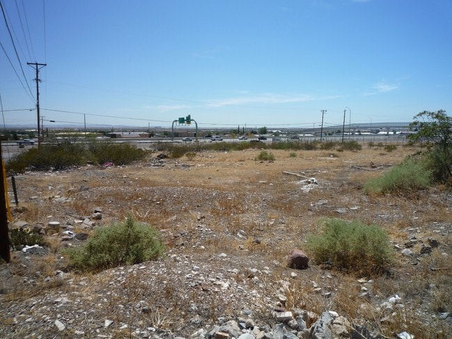
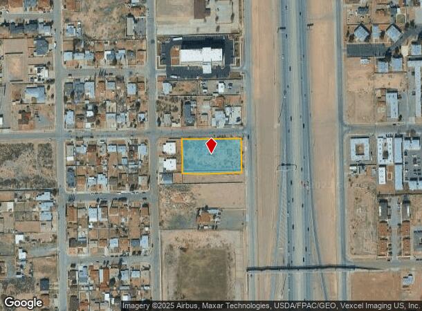
This Property Is For Sale
NEARBY LISTINGS FOR SALE OR LEASE
Property Detail
8687 Gateway Blvd S
El Paso
Sunrise Acres #1
El Paso, TX
SUNRISE ACRES #1 N 158 FT OF 187 & N 158 FT OF E 90 FT OF 188
S912-999-001H-0700
El Paso
Commercialacreage
Texas
2024
1.05 AC
2025
Northeast
000403
DEMOGRAPHICS near 8687 Gateway Blvd S
1 Mile
3 Mile
5 Mile
2024 Total Population
16,164
56,253
143,543
2029 Population
16,582
57,147
145,771
Pop Growth 2024-2029
+ 2.59%
+ 1.59%
+ 1.55%
Average Age
36
37
36
2024 Total Households
6,021
21,055
51,755
HH Growth 2024-2029
+ 2.69%
+ 1.66%
+ 1.59%
Median Household Inc
$31,445
$37,218
$46,671
Avg Household Size
2.60
2.60
2.60
2024 Avg HH Vehicles
2.00
2.00
2.00
Median Home Value
$135,989
$126,970
$140,906
Median Year Built
1974
1970
1974
Nearby Places
Map Layers
Map Styles
 Street
 Aerial
- Restaurants
- Banks
- Shops
- Fitness
- Groceries
PUBLIC TRANSPORTATION
AIRPORT
El Paso International
DRIVE
WALK
Distance
El Paso International
19 min
9.4 mi
Freight Ports
Port of Corpus Christi
DRIVE
WALK
Distance
Port of Corpus Christi
686 min
697.9 mi
Nearby Properties
Address
Land Use
TOTAL SIZE
Lot Size
Zoning
Address
Land Use
TOTAL SIZE
Lot Size
Zoning
261,148 SF
21.61 AC
PR2
Address
Land Use
TOTAL SIZE
Lot Size
Zoning
117,210 SF
8.55 AC
R4
Address
Land Use
TOTAL SIZE
Lot Size
Zoning
73,904 SF
42.88 AC
R4
Address
Land Use
TOTAL SIZE
Lot Size
Zoning
136,000 SF
84.83 AC
R4
Address
Land Use
TOTAL SIZE
Lot Size
Zoning
240,114 SF
26.84 AC
C1
Address
Land Use
TOTAL SIZE
Lot Size
Zoning
348,316 SF
39.67 AC
R4
Address
Land Use
TOTAL SIZE
Lot Size
Zoning
177.87 AC
Address
Land Use
TOTAL SIZE
Lot Size
Zoning
140,086 SF
13.13 AC
C3
Address
Land Use
TOTAL SIZE
Lot Size
Zoning
251,542 SF
12.76 AC
C1
Address
Land Use
TOTAL SIZE
Lot Size
Zoning
88,806 SF
9.41 AC
C1S
Address
Land Use
TOTAL SIZE
Lot Size
Zoning
112,888 SF
5.60 AC
SCZ
Address
Land Use
TOTAL SIZE
Lot Size
Zoning
164,884 SF
14.65 AC
C4
Address
Land Use
TOTAL SIZE
Lot Size
Zoning
254,768 SF
10.11 AC
A2
Address
Land Use
TOTAL SIZE
Lot Size
Zoning
28,289 SF
3.31 AC
C1
Address
Land Use
TOTAL SIZE
Lot Size
Zoning
136,880 SF
19.21 AC
C3
Address
Land Use
TOTAL SIZE
Lot Size
Zoning
67,808 SF
9.64 AC
C1
Address
Land Use
TOTAL SIZE
Lot Size
Zoning
44,178 SF
1.03 AC
A1C
Address
Land Use
TOTAL SIZE
Lot Size
Zoning
219,241 SF
6.92 AC
M1
Address
Land Use
TOTAL SIZE
Lot Size
Zoning
113,724 SF
9.65 AC
C3
Address
Land Use
TOTAL SIZE
Lot Size
Zoning
68,431 SF
2.41 AC
R4
Address
Land Use
TOTAL SIZE
Lot Size
Zoning
27,963 SF
2 AC
C1
Address
Land Use
TOTAL SIZE
Lot Size
Zoning
211,730 SF
8.52 AC
C3S
Address
Land Use
TOTAL SIZE
Lot Size
Zoning
113,864 SF
11.34 AC
C4
Address
Land Use
TOTAL SIZE
Lot Size
Zoning
45,752 SF
3.05 AC
R4
Address
Land Use
TOTAL SIZE
Lot Size
Zoning
256,048 SF
36.89 AC
R4
Address
Land Use
TOTAL SIZE
Lot Size
Zoning
113,898 SF
8.88 AC
M1
Address
Land Use
TOTAL SIZE
Lot Size
Zoning
41,412 SF
6.36 AC
AM
Address
Land Use
TOTAL SIZE
Lot Size
Zoning
69,126 SF
12.65 AC
C1
Address
Land Use
TOTAL SIZE
Lot Size
Zoning
66,636 SF
2.07 AC
R4
Address
Land Use
TOTAL SIZE
Lot Size
Zoning
111,183 SF
38.65 AC
M3
The World's #1 Commercial Real Estate Marketplace
Connect with us
© 2026 CoStar Group
The information above has been obtained from sources believed reliable. While we do not doubt its accuracy we have not verified it and make no guarantee, warranty or representation about it. It is your responsibility to independently confirm its accuracy and completeness. Any projections, opinions, assumptions, or estimates used are for example only and do not represent the current or future performance of the property. The value of this transaction to you depends on tax and other factors which should be evaluated by your tax, financial, and legal advisors. You and your advisors should conduct a careful, independent investigation of the property to determine to your satisfaction the suitability of the property for your needs.