Property Record
869 Blue Ridge Rd, Black Mountain, NC 28711
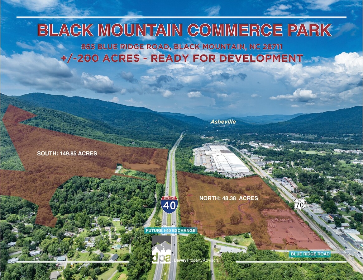
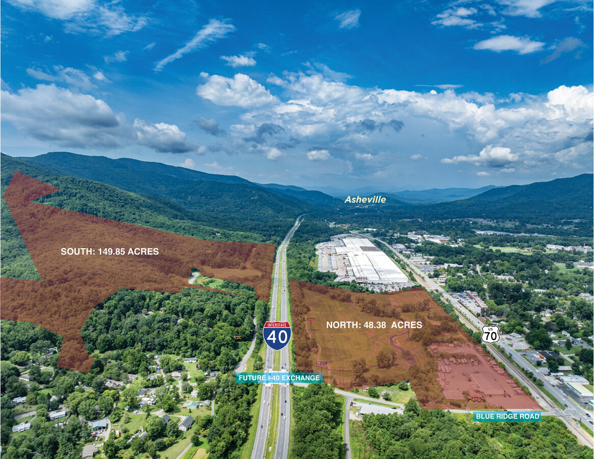
This Property Is For Sale
NEARBY LISTINGS FOR SALE OR LEASE
-
-
View all Black Mountain listings for sale on LoopNet.com
Property Detail
869 Blue Ridge Rd
Asheville, NC
Black Mountain Center
0609-63-7027-00000
LOT: LOT 3 PLAT: 0190-0043
Commercialnec
Buncombe
AE
North Carolina
3710060900J
3
2023
10.55 AC
2023
Buncombe County
003002
Asheville
19,235 SF
DEMOGRAPHICS near 869 Blue Ridge Rd
1 Mile
3 Mile
5 Mile
2024 Total Population
3,354
15,855
24,687
2029 Population
3,515
16,470
25,765
Pop Growth 2024-2029
+ 4.80%
+ 3.88%
+ 4.37%
Average Age
49
46
45
2024 Total Households
1,380
6,702
10,168
HH Growth 2024-2029
+ 4.49%
+ 3.40%
+ 3.92%
Median Household Inc
$75,184
$65,224
$64,284
Avg Household Size
2.10
2.20
2.30
2024 Avg HH Vehicles
2.00
2.00
2.00
Median Home Value
$350,238
$322,789
$306,155
Median Year Built
1989
1985
1986
Nearby Places
- Restaurants
- Banks
- Shops
- Fitness
- Groceries
PUBLIC TRANSPORTATION
AIRPORT
Asheville Regional
DRIVE
WALK
Distance
Asheville Regional
35 min
23.3 mi
Freight Ports
North Charleston Terminal
DRIVE
WALK
Distance
North Charleston Terminal
307 min
267.0 mi
Nearby Properties
Address
Land Use
TOTAL SIZE
Lot Size
Zoning
Address
Land Use
TOTAL SIZE
Lot Size
Zoning
356,506 SF
689.12 AC
CR
Address
Land Use
TOTAL SIZE
Lot Size
Zoning
810,074 SF
46.41 AC
LI-8
Address
Land Use
TOTAL SIZE
Lot Size
Zoning
192,232 SF
119.64 AC
OI-6
Address
Land Use
TOTAL SIZE
Lot Size
Zoning
405,624 SF
75.73 AC
OI-6
Address
Land Use
TOTAL SIZE
Lot Size
Zoning
53,002 SF
7.06 AC
I
Address
Land Use
TOTAL SIZE
Lot Size
Zoning
771,179 SF
73.04 AC
LI-8
Address
Land Use
TOTAL SIZE
Lot Size
Zoning
27,837 SF
1,153.53 AC
CR
Address
Land Use
TOTAL SIZE
Lot Size
Zoning
72,628 SF
8.65 AC
C-2
Address
Land Use
TOTAL SIZE
Lot Size
Zoning
105,431 SF
10.79 AC
HB-8
Address
Land Use
TOTAL SIZE
Lot Size
Zoning
70,225 SF
278.55 AC
PS
Address
Land Use
TOTAL SIZE
Lot Size
Zoning
14,692 SF
11 AC
PS
Address
Land Use
TOTAL SIZE
Lot Size
Zoning
32,988 SF
89.19 AC
ICD
Address
Land Use
TOTAL SIZE
Lot Size
Zoning
37,471 SF
7.56 AC
OI-6
Address
Land Use
TOTAL SIZE
Lot Size
Zoning
28,512 SF
4.22 AC
HB-8
Address
Land Use
TOTAL SIZE
Lot Size
Zoning
45,100 SF
7.29 AC
R-2
Address
Land Use
TOTAL SIZE
Lot Size
Zoning
43,236 SF
26.92 AC
I
Address
Land Use
TOTAL SIZE
Lot Size
Zoning
43,219 SF
10.74 AC
HB-8
Address
Land Use
TOTAL SIZE
Lot Size
Zoning
41,290 SF
112.91 AC
R-LD
Address
Land Use
TOTAL SIZE
Lot Size
Zoning
165,852 SF
14.02 AC
HI-0
Address
Land Use
TOTAL SIZE
Lot Size
Zoning
27,762 SF
4.45 AC
C-2
Address
Land Use
TOTAL SIZE
Lot Size
Zoning
14,172 SF
3.17 AC
HB-8
Address
Land Use
TOTAL SIZE
Lot Size
Zoning
31,196 SF
43.77 AC
PS
Address
Land Use
TOTAL SIZE
Lot Size
Zoning
40,776 SF
123.72 AC
UR-8
Address
Land Use
TOTAL SIZE
Lot Size
Zoning
19,200 SF
1.25 AC
I
Address
Land Use
TOTAL SIZE
Lot Size
Zoning
22,704 SF
4.85 AC
CR
Address
Land Use
TOTAL SIZE
Lot Size
Zoning
16,092 SF
1.94 AC
TND
Address
Land Use
TOTAL SIZE
Lot Size
Zoning
40,644 SF
5.60 AC
HB-8
Address
Land Use
TOTAL SIZE
Lot Size
Zoning
12,368 SF
2.12 AC
HB-8
Address
Land Use
TOTAL SIZE
Lot Size
Zoning
19,489 SF
3.29 AC
HB-8
Address
Land Use
TOTAL SIZE
Lot Size
Zoning
47,890 SF
7.10 AC
HI-0
The World's #1 Commercial Real Estate Marketplace
Connect with us
© 2025 CoStar Group
The information above has been obtained from sources believed reliable. While we do not doubt its accuracy we have not verified it and make no guarantee, warranty or representation about it. It is your responsibility to independently confirm its accuracy and completeness. Any projections, opinions, assumptions, or estimates used are for example only and do not represent the current or future performance of the property. The value of this transaction to you depends on tax and other factors which should be evaluated by your tax, financial, and legal advisors. You and your advisors should conduct a careful, independent investigation of the property to determine to your satisfaction the suitability of the property for your needs.