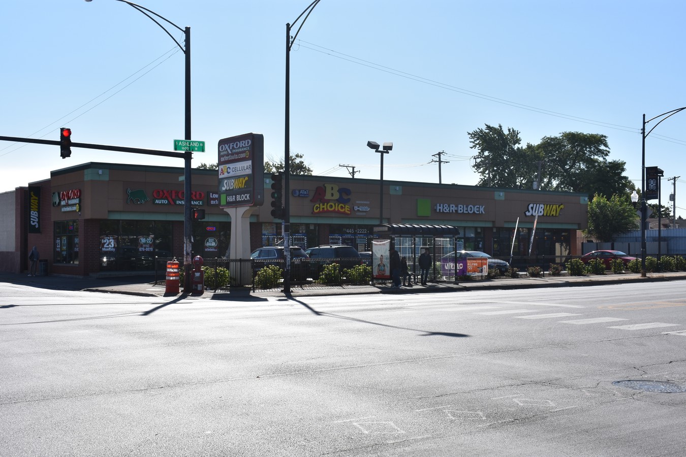
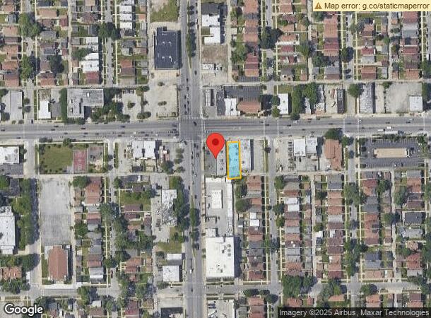
Property Record
8701 S Ashland Ave, Chicago, IL 60620
NEARBY LISTINGS FOR SALE OR LEASE
Property Detail
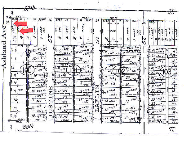
8701 S Ashland Ave
Chicago-Naperville-Elgin, IL-IN-WI
Brainerds Sub
25-05-100-003-0000
E L (BRAINERDS) SUB OF TELFORD BURNHAMS SUB EXCEPT BL KS 1&8 SUB OF WH NW SEC 05-37-14
Commercialbuilding
Cook
X
Illinois
17031C0635J
3
2022
0.17 AC
2024
South Chicago
711400
Chicago
10,610 SF
DEMOGRAPHICS near 8701 S Ashland Ave
1 Mile
3 Mile
5 Mile
2024 Total Population
30,124
229,036
651,721
2029 Population
28,944
220,489
625,750
Pop Growth 2024-2029
(3.92%)
(3.73%)
(3.98%)
Average Age
42
41
39
2024 Total Households
11,940
85,460
238,058
HH Growth 2024-2029
(4.33%)
(4.14%)
(4.19%)
Median Household Inc
$50,691
$51,007
$47,637
Avg Household Size
2.40
2.60
2.60
2024 Avg HH Vehicles
1.00
1.00
1.00
Median Home Value
$175,878
$189,076
$194,213
Median Year Built
1948
1949
1951
Nearby Places
- Restaurants
- Banks
- Shops
- Fitness
- Groceries
PUBLIC TRANSPORTATION
COMMUTER RAIL
Brainerd Station (Rock Island District Line - Northeast Illinois Regional Commuter Railroad (Metra))
DRIVE
WALK
Distance
Brainerd Station (Rock Island District Line - Northeast Illinois Regional Commuter Railroad (Metra))
1 min
9 min
0.5 mi
Beverly-91St Street Station (Rock Island District Line - Northeast Illinois Regional Commuter Railroad (Metra))
DRIVE
WALK
Distance
Beverly-91St Street Station (Rock Island District Line - Northeast Illinois Regional Commuter Railroad (Metra))
5 min
14 min
0.7 mi
AIRPORT
Chicago Midway International
DRIVE
WALK
Distance
Chicago Midway International
16 min
8.7 mi
Chicago O'Hare International
DRIVE
WALK
Distance
Chicago O'Hare International
45 min
29.6 mi
Freight Ports
Port Milwaukee
DRIVE
WALK
Distance
Port Milwaukee
123 min
97.8 mi
SALE & LEASE HISTORY
LISTING DATE
SALE/LEASE

Sep 11, 2023
For Sale
May 10, 2021
For Lease
Jul 29, 2019
For Lease
Feb 28, 2018
For Lease
Nearby Properties
Address
Land Use
TOTAL SIZE
Lot Size
Zoning
Address
Land Use
TOTAL SIZE
Lot Size
Zoning
10.73 AC
PD 1243
Address
Land Use
TOTAL SIZE
Lot Size
Zoning
11 AC
PD 1168
Address
Land Use
TOTAL SIZE
Lot Size
Zoning
1,615,006 SF
41.91 AC
PMD13
Address
Land Use
TOTAL SIZE
Lot Size
Zoning
159,300 SF
13.36 AC
PD 425
Address
Land Use
TOTAL SIZE
Lot Size
Zoning
87,830 SF
0.76 AC
B1-1
Address
Land Use
TOTAL SIZE
Lot Size
Zoning
151,175 SF
11.53 AC
PD 966
Address
Land Use
TOTAL SIZE
Lot Size
Zoning
157,787 SF
12.23 AC
Address
Land Use
TOTAL SIZE
Lot Size
Zoning
Address
Land Use
TOTAL SIZE
Lot Size
Zoning
223,310 SF
15.66 AC
Address
Land Use
TOTAL SIZE
Lot Size
Zoning
224,089 SF
Address
Land Use
TOTAL SIZE
Lot Size
Zoning
99,900 SF
12.45 AC
PD 1172
Address
Land Use
TOTAL SIZE
Lot Size
Zoning
141,165 SF
7.82 AC
PD 966
Address
Land Use
TOTAL SIZE
Lot Size
Zoning
111,198 SF
10.60 AC
PD 566
Address
Land Use
TOTAL SIZE
Lot Size
Zoning
82,000 SF
Address
Land Use
TOTAL SIZE
Lot Size
Zoning
166,292 SF
5.95 AC
PMD13
Address
Land Use
TOTAL SIZE
Lot Size
Zoning
13,700 SF
0.33 AC
B3-2
Address
Land Use
TOTAL SIZE
Lot Size
Zoning
1 AC
RS-3
Address
Land Use
TOTAL SIZE
Lot Size
Zoning
285,672 SF
13.14 AC
Address
Land Use
TOTAL SIZE
Lot Size
Zoning
65,186 SF
10.47 AC
PD 566
Address
Land Use
TOTAL SIZE
Lot Size
Zoning
101,294 SF
8.10 AC
B3-1
Address
Land Use
TOTAL SIZE
Lot Size
Zoning
0.25 AC
PD 548
Address
Land Use
TOTAL SIZE
Lot Size
Zoning
0.54 AC
RS-3
Address
Land Use
TOTAL SIZE
Lot Size
Zoning
76,363 SF
6.40 AC
B3-1
Address
Land Use
TOTAL SIZE
Lot Size
Zoning
69,857 SF
5.39 AC
PD 338
Address
Land Use
TOTAL SIZE
Lot Size
Zoning
91,200 SF
3.41 AC
PMD13
Address
Land Use
TOTAL SIZE
Lot Size
Zoning
0.47 AC
PD 548
Address
Land Use
TOTAL SIZE
Lot Size
Zoning
Address
Land Use
TOTAL SIZE
Lot Size
Zoning
66,152 SF
5.47 AC
PD 430
Address
Land Use
TOTAL SIZE
Lot Size
Zoning
0.35 AC
RS-3
Address
Land Use
TOTAL SIZE
Lot Size
Zoning
502,200 SF
8.04 AC
M2-2
The World's #1 Commercial Real Estate Marketplace
Connect with us
© 2025 CoStar Group
The information above has been obtained from sources believed reliable. While we do not doubt its accuracy we have not verified it and make no guarantee, warranty or representation about it. It is your responsibility to independently confirm its accuracy and completeness. Any projections, opinions, assumptions, or estimates used are for example only and do not represent the current or future performance of the property. The value of this transaction to you depends on tax and other factors which should be evaluated by your tax, financial, and legal advisors. You and your advisors should conduct a careful, independent investigation of the property to determine to your satisfaction the suitability of the property for your needs.