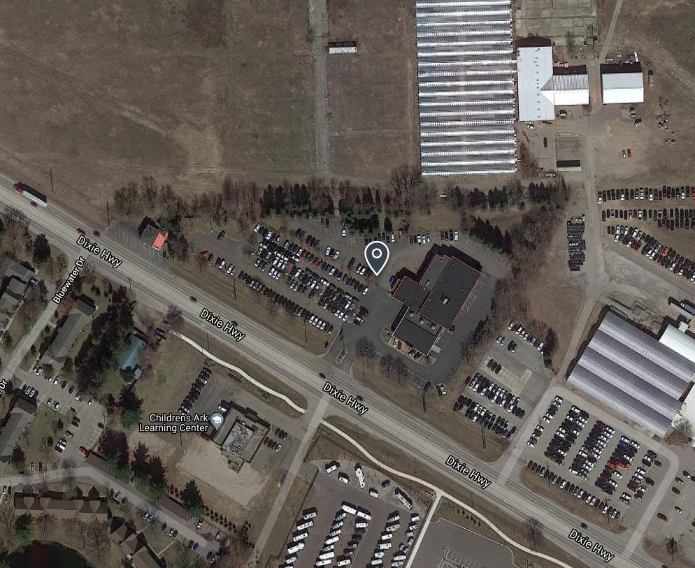
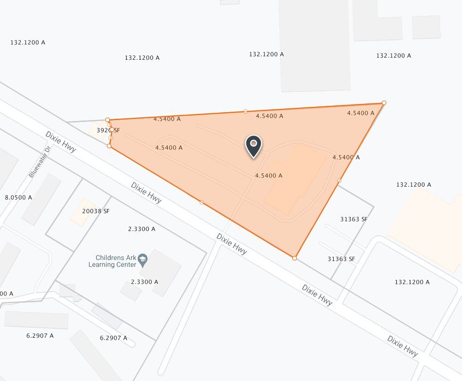
Property Record
8731 Dixie Hwy, Clarkston, MI 48348
NEARBY LISTINGS FOR SALE OR LEASE
Property Detail
8731 Dixie Hwy
07-24-101-011
Supervisors Peat Of Springfield Estates
Vehiclerentalsvehiclesales
T4N, R8E, SEC 24 PART OF NW 1/4 BEG AT PT DIST N 87-11-45 E 1331.44 FT & N 02-02-26 W 1786.64 FT & N 29-58-32 E 229.91 FT FROM W 1/4 COR, TH N 59-12-36 W 349.18 FT, TH N 33-41-51 E 299.90 FT, TH S 59-13-36 E 329.71 FT, TH S 29-58-32 W 299.64 FT TO BE
X
Oakland
26125C0327F
Michigan
2024
2.33 AC
2024
St Clair & Lapeer Counties
126300
Detroit
13,667 SF
Detroit-Warren-Dearborn, MI
DEMOGRAPHICS near 8731 Dixie Hwy
1 Mile
3 Mile
5 Mile
2024 Total Population
2,217
18,926
49,152
2029 Population
2,199
18,763
48,723
Pop Growth 2024-2029
(0.81%)
(0.86%)
(0.87%)
Average Age
43
43
43
2024 Total Households
857
7,050
19,146
HH Growth 2024-2029
(0.82%)
(0.92%)
(0.97%)
Median Household Inc
$92,567
$114,817
$99,985
Avg Household Size
2.60
2.60
2.50
2024 Avg HH Vehicles
2.00
2.00
2.00
Median Home Value
$426,618
$369,505
$323,471
Median Year Built
1990
1983
1980
Nearby Places
- Restaurants
- Banks
- Shops
- Fitness
- Groceries
PUBLIC TRANSPORTATION
AIRPORT
Bishop International
DRIVE
WALK
Distance
Bishop International
39 min
25.6 mi
Freight Ports
Port of Toledo
DRIVE
WALK
Distance
Port of Toledo
112 min
87.2 mi
Nearby Properties
Address
Land Use
TOTAL SIZE
Lot Size
Zoning
Address
Land Use
TOTAL SIZE
Lot Size
Zoning
208,006 SF
1.24 AC
R2
Address
Land Use
TOTAL SIZE
Lot Size
Zoning
68,725 SF
4.96 AC
PUD
Address
Land Use
TOTAL SIZE
Lot Size
Zoning
327,288 SF
19.85 AC
R2
Address
Land Use
TOTAL SIZE
Lot Size
Zoning
78,261 SF
7.80 AC
PUD
Address
Land Use
TOTAL SIZE
Lot Size
Zoning
44.10 AC
PUD
Address
Land Use
TOTAL SIZE
Lot Size
Zoning
87,130 SF
9.01 AC
C-3
Address
Land Use
TOTAL SIZE
Lot Size
Zoning
19,504 SF
3.16 AC
ML
Address
Land Use
TOTAL SIZE
Lot Size
Zoning
151,736 SF
26.03 AC
C-2
Address
Land Use
TOTAL SIZE
Lot Size
Zoning
48,645 SF
6.68 AC
PUD
Address
Land Use
TOTAL SIZE
Lot Size
Zoning
32,059 SF
BLL
Address
Land Use
TOTAL SIZE
Lot Size
Zoning
739 SF
5.36 AC
R1A
Address
Land Use
TOTAL SIZE
Lot Size
Zoning
143,550 SF
11.92 AC
R2
Address
Land Use
TOTAL SIZE
Lot Size
Zoning
34,111 SF
20.14 AC
Address
Land Use
TOTAL SIZE
Lot Size
Zoning
82,864 SF
30.65 AC
MH
Address
Land Use
TOTAL SIZE
Lot Size
Zoning
34,807 SF
3.34 AC
OS-2
Address
Land Use
TOTAL SIZE
Lot Size
Zoning
30,726 SF
3.44 AC
R3
Address
Land Use
TOTAL SIZE
Lot Size
Zoning
30,711 SF
3.17 AC
PUD
Address
Land Use
TOTAL SIZE
Lot Size
Zoning
80,974 SF
8.37 AC
C-3
Address
Land Use
TOTAL SIZE
Lot Size
Zoning
261,633 SF
1,321.20 AC
C2GEN
Address
Land Use
TOTAL SIZE
Lot Size
Zoning
26,221 SF
15.76 AC
C2
Address
Land Use
TOTAL SIZE
Lot Size
Zoning
31,057 SF
5.40 AC
BI
Address
Land Use
TOTAL SIZE
Lot Size
Zoning
44,258 SF
8.86 AC
C2GEN
Address
Land Use
TOTAL SIZE
Lot Size
Zoning
0.87 AC
O
Address
Land Use
TOTAL SIZE
Lot Size
Zoning
40,909 SF
3.73 AC
AI
Address
Land Use
TOTAL SIZE
Lot Size
Zoning
18,264 SF
2.27 AC
O
Address
Land Use
TOTAL SIZE
Lot Size
Zoning
40,274 SF
3.26 AC
C-3
Address
Land Use
TOTAL SIZE
Lot Size
Zoning
59,491 SF
6.94 AC
C2GEN
Address
Land Use
TOTAL SIZE
Lot Size
Zoning
30,082 SF
3.39 AC
C-2
Address
Land Use
TOTAL SIZE
Lot Size
Zoning
32,400 SF
3.43 AC
ML
Address
Land Use
TOTAL SIZE
Lot Size
Zoning
74,592 SF
8.05 AC
RMMULT
The World's #1 Commercial Real Estate Marketplace
Connect with us
© 2025 CoStar Group
The information above has been obtained from sources believed reliable. While we do not doubt its accuracy we have not verified it and make no guarantee, warranty or representation about it. It is your responsibility to independently confirm its accuracy and completeness. Any projections, opinions, assumptions, or estimates used are for example only and do not represent the current or future performance of the property. The value of this transaction to you depends on tax and other factors which should be evaluated by your tax, financial, and legal advisors. You and your advisors should conduct a careful, independent investigation of the property to determine to your satisfaction the suitability of the property for your needs.