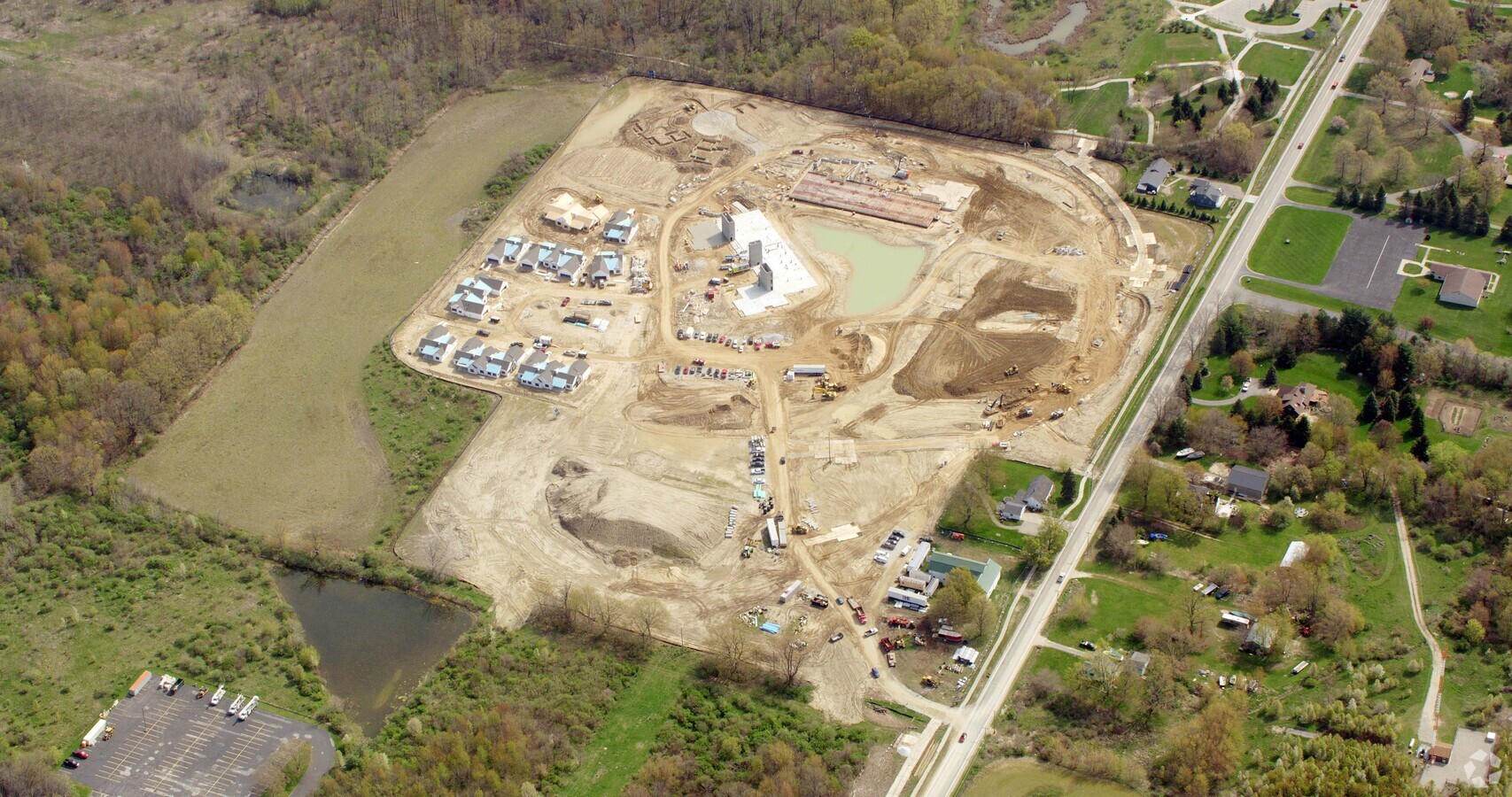
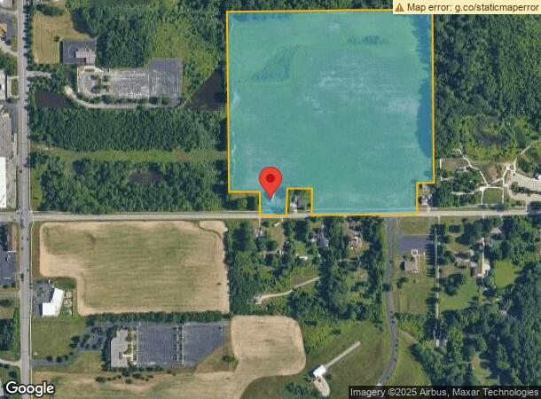
Property Record
875 E 24Th St, Holland, MI 49423
NEARBY LISTINGS FOR SALE OR LEASE
-
-
View all Holland listings for sale on LoopNet.com
Property Detail
875 E 24Th St
70-16-34-100-025
PRIOR REF 2019-0040485 11/01/2019
Multifamilydwelling
Ottawa
X
Michigan
26139C0315E
37.99 AC
2023
Holland/Zeeland
2024
West Michigan
025200
Grand Rapids-Wyoming, MI
36,505 SF
DEMOGRAPHICS near 875 E 24Th St
1 Mile
3 Mile
5 Mile
2024 Total Population
5,389
39,425
90,847
2029 Population
5,621
41,051
94,626
Pop Growth 2024-2029
+ 4.31%
+ 4.12%
+ 4.16%
Average Age
40
38
39
2024 Total Households
2,205
14,606
33,829
HH Growth 2024-2029
+ 4.35%
+ 4.24%
+ 4.30%
Median Household Inc
$65,238
$68,133
$72,285
Avg Household Size
2.30
2.50
2.60
2024 Avg HH Vehicles
2.00
2.00
2.00
Median Home Value
$230,357
$220,863
$237,254
Median Year Built
1980
1974
1982
Nearby Places
- Restaurants
- Banks
- Shops
- Fitness
- Groceries
PUBLIC TRANSPORTATION
COMMUTER RAIL
Holland Amtrak Station (Pere Marquette - Amtrak)
DRIVE
WALK
Distance
Holland Amtrak Station (Pere Marquette - Amtrak)
6 min
2.7 mi
AIRPORT
Gerald R Ford International
DRIVE
WALK
Distance
Gerald R Ford International
45 min
34.0 mi
Freight Ports
Port Milwaukee
DRIVE
WALK
Distance
Port Milwaukee
277 min
236.0 mi
Nearby Properties
Address
Land Use
TOTAL SIZE
Lot Size
Zoning
Address
Land Use
TOTAL SIZE
Lot Size
Zoning
1,271,617 SF
Address
Land Use
TOTAL SIZE
Lot Size
Zoning
1,271,617 SF
Address
Land Use
TOTAL SIZE
Lot Size
Zoning
572,832 SF
10.89 AC
PUD
Address
Land Use
TOTAL SIZE
Lot Size
Zoning
1,788,352 SF
173.33 AC
I
Address
Land Use
TOTAL SIZE
Lot Size
Zoning
1,788,352 SF
173.33 AC
Address
Land Use
TOTAL SIZE
Lot Size
Zoning
662,015 SF
177 AC
SEE MAP
Address
Land Use
TOTAL SIZE
Lot Size
Zoning
198,712 SF
N/A
Address
Land Use
TOTAL SIZE
Lot Size
Zoning
198,712 SF
Address
Land Use
TOTAL SIZE
Lot Size
Zoning
669,422 SF
28.50 AC
Address
Land Use
TOTAL SIZE
Lot Size
Zoning
669,422 SF
28.50 AC
I
Address
Land Use
TOTAL SIZE
Lot Size
Zoning
218,722 SF
8.59 AC
AGR
Address
Land Use
TOTAL SIZE
Lot Size
Zoning
508,619 SF
85.45 AC
Address
Land Use
TOTAL SIZE
Lot Size
Zoning
508,619 SF
85.45 AC
I-2
Address
Land Use
TOTAL SIZE
Lot Size
Zoning
171 AC
Address
Land Use
TOTAL SIZE
Lot Size
Zoning
132,127 SF
42.69 AC
SEE MAP
Address
Land Use
TOTAL SIZE
Lot Size
Zoning
657,052 SF
79.30 AC
I-2
Address
Land Use
TOTAL SIZE
Lot Size
Zoning
657,052 SF
79.30 AC
Address
Land Use
TOTAL SIZE
Lot Size
Zoning
660,002 SF
32.13 AC
I-2
Address
Land Use
TOTAL SIZE
Lot Size
Zoning
118,444 SF
4.39 AC
Address
Land Use
TOTAL SIZE
Lot Size
Zoning
118,444 SF
4.39 AC
PUD
Address
Land Use
TOTAL SIZE
Lot Size
Zoning
239,465 SF
Address
Land Use
TOTAL SIZE
Lot Size
Zoning
239,465 SF
Address
Land Use
TOTAL SIZE
Lot Size
Zoning
22.66 AC
Address
Land Use
TOTAL SIZE
Lot Size
Zoning
58,710 SF
6.96 AC
C-2
Address
Land Use
TOTAL SIZE
Lot Size
Zoning
249,051 SF
22.15 AC
PUD
Address
Land Use
TOTAL SIZE
Lot Size
Zoning
209,455 SF
17 AC
C-2
Address
Land Use
TOTAL SIZE
Lot Size
Zoning
94,790 SF
1.74 AC
C-2
Address
Land Use
TOTAL SIZE
Lot Size
Zoning
150,822 SF
Address
Land Use
TOTAL SIZE
Lot Size
Zoning
150,822 SF
N/A
The World's #1 Commercial Real Estate Marketplace
Connect with us
© 2025 CoStar Group
The information above has been obtained from sources believed reliable. While we do not doubt its accuracy we have not verified it and make no guarantee, warranty or representation about it. It is your responsibility to independently confirm its accuracy and completeness. Any projections, opinions, assumptions, or estimates used are for example only and do not represent the current or future performance of the property. The value of this transaction to you depends on tax and other factors which should be evaluated by your tax, financial, and legal advisors. You and your advisors should conduct a careful, independent investigation of the property to determine to your satisfaction the suitability of the property for your needs.