Property Record
8795 Highway 87 S, Milton, FL 32583


NEARBY LISTINGS FOR SALE OR LEASE
Property Detail
8795 Highway 87 S
Pensacola-Ferry Pass-Brent, FL
Santa Rosa
09-1N-27-0000-01000-0000
Florida
Sfr
12.60 AC
X
SE Santa Rosa County
12113C0455H
Pensacola
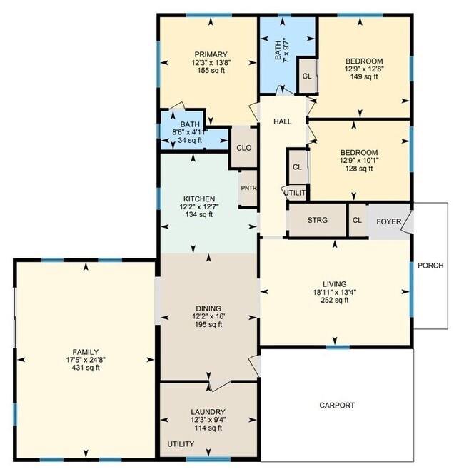
1,911 SF
DEMOGRAPHICS near 8795 Highway 87 S
1 Mile
3 Mile
5 Mile
2024 Total Population
616
10,379
17,616
2029 Population
709
11,934
20,302
Pop Growth 2024-2029
+ 15.10%
+ 14.98%
+ 15.25%
Average Age
42
41
42
2024 Total Households
205
2,999
5,596
HH Growth 2024-2029
+ 16.10%
+ 17.61%
+ 17.10%
Median Household Inc
$77,045
$64,870
$63,402
Avg Household Size
2.50
2.40
2.50
2024 Avg HH Vehicles
2.00
2.00
2.00
Median Home Value
$261,412
$198,886
$206,621
Median Year Built
1990
1999
1996
Nearby Places
Map Layers
Map Styles
 Street
 Aerial
- Restaurants
- Banks
- Shops
- Fitness
- Groceries
PUBLIC TRANSPORTATION
AIRPORT
Pensacola International
DRIVE
WALK
Distance
Pensacola International
33 min
22.8 mi
Eglin AFB/Destin-Ft Walton Beach
DRIVE
WALK
Distance
Eglin AFB/Destin-Ft Walton Beach
71 min
49.1 mi
Freight Ports
Port of Mobile
DRIVE
WALK
Distance
Port of Mobile
82 min
72.8 mi
SALE & LEASE HISTORY
LISTING DATE
SALE/LEASE

May 27, 2025
For Lease
Jun 28, 2021
For Sale
Nearby Properties
Address
Land Use
TOTAL SIZE
Lot Size
Zoning
Address
Land Use
TOTAL SIZE
Lot Size
Zoning
342,125 SF
58.46 AC
M2
Address
Land Use
TOTAL SIZE
Lot Size
Zoning
281,607 SF
306.03 AC
M2
Address
Land Use
TOTAL SIZE
Lot Size
Zoning
183,076 SF
85.91 AC
M2
Address
Land Use
TOTAL SIZE
Lot Size
Zoning
198,543 SF
34.63 AC
M2
Address
Land Use
TOTAL SIZE
Lot Size
Zoning
31,124 SF
36.55 AC
AG-RR
Address
Land Use
TOTAL SIZE
Lot Size
Zoning
258,149 SF
8.42 AC
M2
Address
Land Use
TOTAL SIZE
Lot Size
Zoning
197,050 SF
29.93 AC
M2
Address
Land Use
TOTAL SIZE
Lot Size
Zoning
141,508 SF
26.62 AC
M2
Address
Land Use
TOTAL SIZE
Lot Size
Zoning
164,844 SF
8.33 AC
M2
Address
Land Use
TOTAL SIZE
Lot Size
Zoning
52,817 SF
79.32 AC
M1
Address
Land Use
TOTAL SIZE
Lot Size
Zoning
67,182 SF
9.54 AC
M2
Address
Land Use
TOTAL SIZE
Lot Size
Zoning
47,976 SF
102.61 AC
M2
Address
Land Use
TOTAL SIZE
Lot Size
Zoning
186.32 AC
HCD
Address
Land Use
TOTAL SIZE
Lot Size
Zoning
82,869 SF
10 AC
M2
Address
Land Use
TOTAL SIZE
Lot Size
Zoning
9,030 SF
20.47 AC
HCD
Address
Land Use
TOTAL SIZE
Lot Size
Zoning
72,675 SF
20 AC
M2
Address
Land Use
TOTAL SIZE
Lot Size
Zoning
103,000 SF
7.24 AC
M2
Address
Land Use
TOTAL SIZE
Lot Size
Zoning
89,249 SF
66.21 AC
AG-RR
Address
Land Use
TOTAL SIZE
Lot Size
Zoning
81,521 SF
7.63 AC
M2
Address
Land Use
TOTAL SIZE
Lot Size
Zoning
51,765 SF
14 AC
M2
Address
Land Use
TOTAL SIZE
Lot Size
Zoning
83,222 SF
7 AC
M2
Address
Land Use
TOTAL SIZE
Lot Size
Zoning
38,619 SF
2.31 AC
HCD
Address
Land Use
TOTAL SIZE
Lot Size
Zoning
199.56 AC
AG-RR
Address
Land Use
TOTAL SIZE
Lot Size
Zoning
33,570 SF
4.25 AC
HCD
Address
Land Use
TOTAL SIZE
Lot Size
Zoning
33,454 SF
13.16 AC
M2
Address
Land Use
TOTAL SIZE
Lot Size
Zoning
82,362 SF
6.95 AC
M2
Address
Land Use
TOTAL SIZE
Lot Size
Zoning
20,964 SF
26.97 AC
M2
Address
Land Use
TOTAL SIZE
Lot Size
Zoning
15,067 SF
3.09 AC
M2
Address
Land Use
TOTAL SIZE
Lot Size
Zoning
20,468 SF
16 AC
M2
Address
Land Use
TOTAL SIZE
Lot Size
Zoning
37,800 SF
3.99 AC
M2
The World's #1 Commercial Real Estate Marketplace
Connect with us
© 2026 CoStar Group
The information above has been obtained from sources believed reliable. While we do not doubt its accuracy we have not verified it and make no guarantee, warranty or representation about it. It is your responsibility to independently confirm its accuracy and completeness. Any projections, opinions, assumptions, or estimates used are for example only and do not represent the current or future performance of the property. The value of this transaction to you depends on tax and other factors which should be evaluated by your tax, financial, and legal advisors. You and your advisors should conduct a careful, independent investigation of the property to determine to your satisfaction the suitability of the property for your needs.