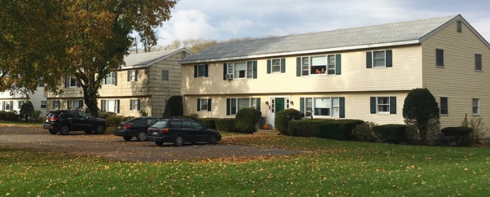
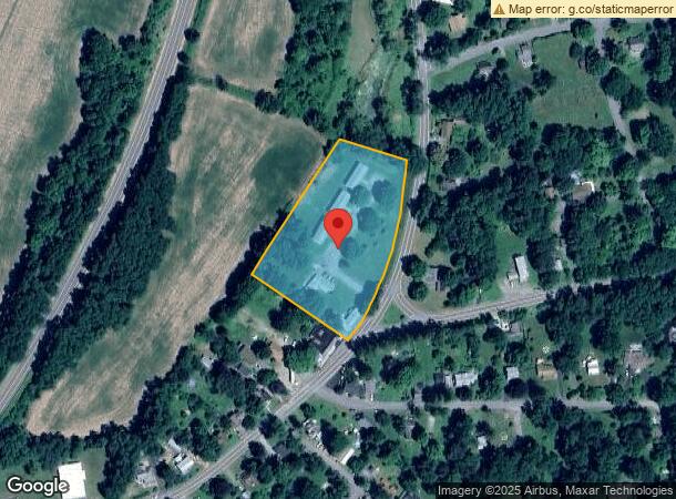
Property Record
88 State Route 344, Copake Falls, NY 12517
NEARBY LISTINGS FOR SALE OR LEASE
-
-
View all Copake Falls listings for sale on LoopNet.com
Property Detail
88 State Route 344
Hudson, NY
Property/Jesse & Rose Head
103200-176-002-0002-001-000-0000
Columbia
Apartment
New York
2023
1.000
2023
2.80 AC
001600
Columbia County
3,616 SF
Albany/Schenectady/Troy
DEMOGRAPHICS near 88 State Route 344
1 Mile
3 Mile
5 Mile
2024 Total Population
243
2,074
5,608
2029 Population
246
2,118
5,726
Pop Growth 2024-2029
+ 1.23%
+ 2.12%
+ 2.10%
Average Age
45
46
47
2024 Total Households
97
862
2,375
HH Growth 2024-2029
+ 1.03%
+ 2.32%
+ 2.27%
Median Household Inc
$91,964
$102,446
$96,806
Avg Household Size
2.30
2.20
2.20
2024 Avg HH Vehicles
2.00
2.00
2.00
Median Home Value
$304,545
$277,214
$329,545
Median Year Built
1965
1968
1969
Nearby Places
- Restaurants
- Banks
- Shops
- Fitness
- Groceries
SALE & LEASE HISTORY
LISTING DATE
SALE/LEASE

Feb 01, 2018
For Sale
Nearby Properties
Address
Land Use
TOTAL SIZE
Lot Size
Zoning
Address
Land Use
TOTAL SIZE
Lot Size
Zoning
2,295.68 AC
Address
Land Use
TOTAL SIZE
Lot Size
Zoning
1,932.50 AC
07 - MIXED
Address
Land Use
TOTAL SIZE
Lot Size
Zoning
3,793 SF
98.75 AC
07 - MIXED
Address
Land Use
TOTAL SIZE
Lot Size
Zoning
1,600 SF
321.10 AC
10
Address
Land Use
TOTAL SIZE
Lot Size
Zoning
4,696 SF
807.25 AC
07 - MIXED
Address
Land Use
TOTAL SIZE
Lot Size
Zoning
4,667 SF
129.83 AC
07 - MIXED
Address
Land Use
TOTAL SIZE
Lot Size
Zoning
784.90 AC
07 - MIXED
Address
Land Use
TOTAL SIZE
Lot Size
Zoning
6,184 SF
3 AC
Address
Land Use
TOTAL SIZE
Lot Size
Zoning
2,453 SF
152.56 AC
07 - MIXED
Address
Land Use
TOTAL SIZE
Lot Size
Zoning
15,568 SF
2.76 AC
07 - MIXED
Address
Land Use
TOTAL SIZE
Lot Size
Zoning
580 AC
Address
Land Use
TOTAL SIZE
Lot Size
Zoning
162.53 AC
07 - MIXED
Address
Land Use
TOTAL SIZE
Lot Size
Zoning
2,995 SF
44.88 AC
07 - MIXED
Address
Land Use
TOTAL SIZE
Lot Size
Zoning
11,105 SF
4.10 AC
R2
Address
Land Use
TOTAL SIZE
Lot Size
Zoning
151.07 AC
07 - MIXED
Address
Land Use
TOTAL SIZE
Lot Size
Zoning
162.61 AC
07 - MIXED
Address
Land Use
TOTAL SIZE
Lot Size
Zoning
2,240 SF
65.26 AC
07 - MIXED
Address
Land Use
TOTAL SIZE
Lot Size
Zoning
3,359 SF
54.94 AC
07 - MIXED
Address
Land Use
TOTAL SIZE
Lot Size
Zoning
139.20 AC
07 - MIXED
Address
Land Use
TOTAL SIZE
Lot Size
Zoning
9,398 SF
15.90 AC
07 - MIXED
Address
Land Use
TOTAL SIZE
Lot Size
Zoning
2,693 SF
19.91 AC
07 - MIXED
Address
Land Use
TOTAL SIZE
Lot Size
Zoning
3,561 SF
9.75 AC
Address
Land Use
TOTAL SIZE
Lot Size
Zoning
3,038 SF
15.81 AC
07 - MIXED
Address
Land Use
TOTAL SIZE
Lot Size
Zoning
15,200 SF
4.01 AC
Address
Land Use
TOTAL SIZE
Lot Size
Zoning
98.90 AC
07 - MIXED
Address
Land Use
TOTAL SIZE
Lot Size
Zoning
16,494 SF
5.94 AC
07 - MIXED
Address
Land Use
TOTAL SIZE
Lot Size
Zoning
220 AC
Address
Land Use
TOTAL SIZE
Lot Size
Zoning
2,783 SF
14.76 AC
07 - MIXED
Address
Land Use
TOTAL SIZE
Lot Size
Zoning
3,315 SF
26 AC
07 - MIXED
The World's #1 Commercial Real Estate Marketplace
Connect with us
© 2025 CoStar Group
The information above has been obtained from sources believed reliable. While we do not doubt its accuracy we have not verified it and make no guarantee, warranty or representation about it. It is your responsibility to independently confirm its accuracy and completeness. Any projections, opinions, assumptions, or estimates used are for example only and do not represent the current or future performance of the property. The value of this transaction to you depends on tax and other factors which should be evaluated by your tax, financial, and legal advisors. You and your advisors should conduct a careful, independent investigation of the property to determine to your satisfaction the suitability of the property for your needs.