Property Record
8836 Jacob Fork River Rd, Vale, NC 28168

NEARBY LISTINGS FOR SALE OR LEASE
-
-
View all Vale listings for sale on LoopNet.com
Property Detail
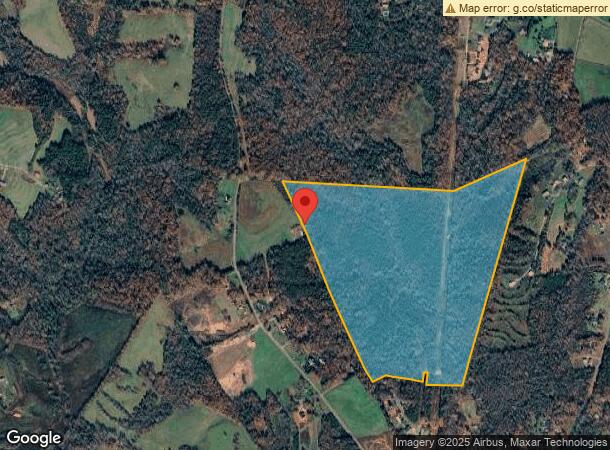
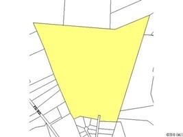
8836 Jacob Fork River Rd
2669033079490000
8836 JACOB FORK RIVER RD
Vacantlandnec
Catawba
X
North Carolina
3710266800J
121.27 AC
2024
Catawba County
2025
Charlotte
070600
Hickory-Lenoir-Morganton, NC
DEMOGRAPHICS near 8836 Jacob Fork River Rd
1 Mile
3 Mile
5 Mile
2024 Total Population
239
3,442
9,493
2029 Population
247
3,528
9,790
Pop Growth 2024-2029
+ 3.35%
+ 2.50%
+ 3.13%
Average Age
42
44
44
2024 Total Households
94
1,363
3,772
HH Growth 2024-2029
+ 3.19%
+ 2.42%
+ 3.15%
Median Household Inc
$45,682
$49,920
$52,447
Avg Household Size
2.50
2.50
2.50
2024 Avg HH Vehicles
3.00
3.00
2.00
Median Home Value
$178,571
$165,242
$166,244
Median Year Built
1984
1983
1982
Nearby Places
Map Layers
Map Styles
 Street
 Aerial
- Restaurants
- Banks
- Shops
- Fitness
- Groceries
SALE & LEASE HISTORY
LISTING DATE
SALE/LEASE

Oct 14, 2016
For Sale
Nearby Properties
Address
Land Use
TOTAL SIZE
Lot Size
Zoning
Address
Land Use
TOTAL SIZE
Lot Size
Zoning
14,364 SF
RURAL MIXE
Address
Land Use
TOTAL SIZE
Lot Size
Zoning
17,160 SF
RURAL MIXE
Address
Land Use
TOTAL SIZE
Lot Size
Zoning
16,487 SF
17.14 AC
R-40
Address
Land Use
TOTAL SIZE
Lot Size
Zoning
5,333 SF
RURAL MIXE
Address
Land Use
TOTAL SIZE
Lot Size
Zoning
9,230 SF
3.16 AC
RURAL MIXE
Address
Land Use
TOTAL SIZE
Lot Size
Zoning
7,308 SF
146.01 AC
R-40
Address
Land Use
TOTAL SIZE
Lot Size
Zoning
4,040 SF
1.26 AC
RURAL MIXE
Address
Land Use
TOTAL SIZE
Lot Size
Zoning
33.47 AC
R-40
Address
Land Use
TOTAL SIZE
Lot Size
Zoning
2,591 SF
2.49 AC
R-40
Address
Land Use
TOTAL SIZE
Lot Size
Zoning
1,490 SF
11.40 AC
R-40
Address
Land Use
TOTAL SIZE
Lot Size
Zoning
18,196 SF
2.35 AC
LI
Address
Land Use
TOTAL SIZE
Lot Size
Zoning
5,751 SF
RURAL MIXE
Address
Land Use
TOTAL SIZE
Lot Size
Zoning
5,224 SF
RURAL MIXE
Address
Land Use
TOTAL SIZE
Lot Size
Zoning
216.48 AC
R-40
Address
Land Use
TOTAL SIZE
Lot Size
Zoning
1,144 SF
105.92 AC
R-40
Address
Land Use
TOTAL SIZE
Lot Size
Zoning
4,738 SF
RURAL MIXE
Address
Land Use
TOTAL SIZE
Lot Size
Zoning
23,848 SF
5.32 AC
RURAL MIXE
Address
Land Use
TOTAL SIZE
Lot Size
Zoning
3,726 SF
3.38 AC
RURAL MIXE
Address
Land Use
TOTAL SIZE
Lot Size
Zoning
16,874 SF
2.89 AC
RURAL MIXE
Address
Land Use
TOTAL SIZE
Lot Size
Zoning
91.77 AC
R-40
Address
Land Use
TOTAL SIZE
Lot Size
Zoning
1,500 SF
RURAL MIXE
Address
Land Use
TOTAL SIZE
Lot Size
Zoning
71.99 AC
R3
Address
Land Use
TOTAL SIZE
Lot Size
Zoning
3,200 SF
RURAL MIXE
Address
Land Use
TOTAL SIZE
Lot Size
Zoning
134.54 AC
RURAL MIXE
Address
Land Use
TOTAL SIZE
Lot Size
Zoning
3,096 SF
RURAL MIXE
Address
Land Use
TOTAL SIZE
Lot Size
Zoning
4,048 SF
RURAL MIXE
Address
Land Use
TOTAL SIZE
Lot Size
Zoning
7,200 SF
1.41 AC
RURAL MIXE
Address
Land Use
TOTAL SIZE
Lot Size
Zoning
RURAL MIXE
Address
Land Use
TOTAL SIZE
Lot Size
Zoning
7,254 SF
RURAL MIXE
The World's #1 Commercial Real Estate Marketplace
Connect with us
© 2026 CoStar Group
The information above has been obtained from sources believed reliable. While we do not doubt its accuracy we have not verified it and make no guarantee, warranty or representation about it. It is your responsibility to independently confirm its accuracy and completeness. Any projections, opinions, assumptions, or estimates used are for example only and do not represent the current or future performance of the property. The value of this transaction to you depends on tax and other factors which should be evaluated by your tax, financial, and legal advisors. You and your advisors should conduct a careful, independent investigation of the property to determine to your satisfaction the suitability of the property for your needs.