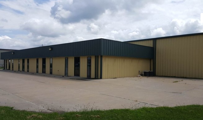
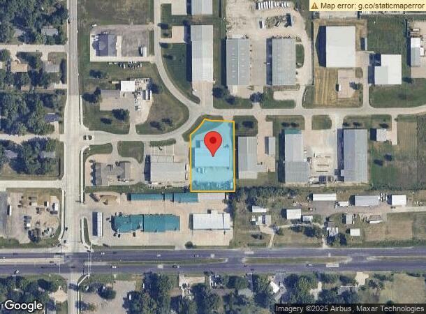
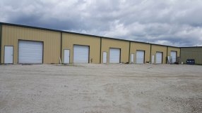
Property Record
8859 Green Valley Dr, Manhattan, KS 66502
NEARBY LISTINGS FOR SALE OR LEASE
Property Detail
8859 Green Valley Dr
Manhattan, KS
Green Valley Bus Pk Un 1
312-10-0-10-04-006.00-0
GREEN VALLEY BUS PK UN 1, S10, T10, R08, LOT 5, ACRES 1.29
Warehouse
Pottawatomie
X
Kansas
20149C0460F
5
2023
1.29 AC
2024
Kansas Area
000102
Other Market Areas
15,000 SF
DEMOGRAPHICS near 8859 Green Valley Dr
1 Mile
3 Mile
5 Mile
2024 Total Population
2,707
9,514
41,832
2029 Population
2,978
10,047
42,681
Pop Growth 2024-2029
+ 10.01%
+ 5.60%
+ 2.03%
Average Age
35
35
31
2024 Total Households
907
3,533
15,791
HH Growth 2024-2029
+ 10.14%
+ 4.92%
+ 1.93%
Median Household Inc
$107,230
$77,805
$45,679
Avg Household Size
2.90
2.60
2.20
2024 Avg HH Vehicles
2.00
2.00
2.00
Median Home Value
$249,701
$208,036
$193,791
Median Year Built
2004
1989
1981
Nearby Places
- Restaurants
- Banks
- Shops
- Fitness
- Groceries
PUBLIC TRANSPORTATION
AIRPORT
Manhattan Regional
DRIVE
WALK
Distance
Manhattan Regional
23 min
12.2 mi
Freight Ports
Tulsa Port Of Catoosa
DRIVE
WALK
Distance
Tulsa Port Of Catoosa
331 min
276.4 mi
SALE & LEASE HISTORY
LISTING DATE
SALE/LEASE

Jun 08, 2023
For Lease
Nearby Properties
Address
Land Use
TOTAL SIZE
Lot Size
Zoning
Address
Land Use
TOTAL SIZE
Lot Size
Zoning
13,351 SF
23.80 AC
R1
Address
Land Use
TOTAL SIZE
Lot Size
Zoning
66,501 SF
14 AC
R1
Address
Land Use
TOTAL SIZE
Lot Size
Zoning
50,903 SF
5.61 AC
A1
Address
Land Use
TOTAL SIZE
Lot Size
Zoning
15,552 SF
9.39 AC
PUD
Address
Land Use
TOTAL SIZE
Lot Size
Zoning
17,496 SF
7.61 AC
PUD
Address
Land Use
TOTAL SIZE
Lot Size
Zoning
22,212 SF
17.77 AC
Address
Land Use
TOTAL SIZE
Lot Size
Zoning
54,570 SF
12.74 AC
Address
Land Use
TOTAL SIZE
Lot Size
Zoning
60,000 SF
8.60 AC
Address
Land Use
TOTAL SIZE
Lot Size
Zoning
190,245 SF
36.81 AC
C4
Address
Land Use
TOTAL SIZE
Lot Size
Zoning
176,432 SF
18.17 AC
Address
Land Use
TOTAL SIZE
Lot Size
Zoning
7,744 SF
12.15 AC
PUD
Address
Land Use
TOTAL SIZE
Lot Size
Zoning
120,458 SF
9.35 AC
Address
Land Use
TOTAL SIZE
Lot Size
Zoning
43,218 SF
6.07 AC
Address
Land Use
TOTAL SIZE
Lot Size
Zoning
21,880 SF
4.74 AC
Address
Land Use
TOTAL SIZE
Lot Size
Zoning
220,494 SF
19.42 AC
Address
Land Use
TOTAL SIZE
Lot Size
Zoning
130,370 SF
8.17 AC
Address
Land Use
TOTAL SIZE
Lot Size
Zoning
5,337 SF
33.58 AC
A1
Address
Land Use
TOTAL SIZE
Lot Size
Zoning
79,296 SF
6.35 AC
PUD
Address
Land Use
TOTAL SIZE
Lot Size
Zoning
0.97 AC
Address
Land Use
TOTAL SIZE
Lot Size
Zoning
23,190 SF
2.80 AC
R1
Address
Land Use
TOTAL SIZE
Lot Size
Zoning
281,498 SF
13 AC
Address
Land Use
TOTAL SIZE
Lot Size
Zoning
7,182 SF
5.60 AC
Address
Land Use
TOTAL SIZE
Lot Size
Zoning
16,035 SF
4.94 AC
Address
Land Use
TOTAL SIZE
Lot Size
Zoning
14,700 SF
2.93 AC
Address
Land Use
TOTAL SIZE
Lot Size
Zoning
10,695 SF
1.37 AC
Address
Land Use
TOTAL SIZE
Lot Size
Zoning
169,696 SF
7.37 AC
Address
Land Use
TOTAL SIZE
Lot Size
Zoning
49,412 SF
2.04 AC
Address
Land Use
TOTAL SIZE
Lot Size
Zoning
43,034 SF
10.15 AC
Address
Land Use
TOTAL SIZE
Lot Size
Zoning
142,010 SF
20.44 AC
Address
Land Use
TOTAL SIZE
Lot Size
Zoning
2,400 SF
82.27 AC
AG
The World's #1 Commercial Real Estate Marketplace
Connect with us
© 2025 CoStar Group
The information above has been obtained from sources believed reliable. While we do not doubt its accuracy we have not verified it and make no guarantee, warranty or representation about it. It is your responsibility to independently confirm its accuracy and completeness. Any projections, opinions, assumptions, or estimates used are for example only and do not represent the current or future performance of the property. The value of this transaction to you depends on tax and other factors which should be evaluated by your tax, financial, and legal advisors. You and your advisors should conduct a careful, independent investigation of the property to determine to your satisfaction the suitability of the property for your needs.