Property Record
8860 Wildcat Rd, Tipp City, OH 45371
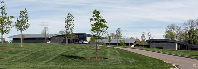

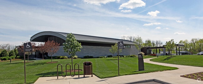
Property Detail
8860 Wildcat Rd
A01038000
9-2-32 CEN PT SE
Commercialnec
Miami
B and X Area of moderate flood hazard, usually the area between the limits of the 100-year and 500-year floods.
Ohio
2025
13.15 AC
2025
North Dayton
380100
Cincinnati/Dayton
43,850 SF
Dayton, OH
NEARBY LISTINGS FOR SALE OR LEASE
DEMOGRAPHICS near 8860 Wildcat Rd
1 mile
3 mile
5 mile
2025 Total Population
626
25,941
68,225
2030 Population
654
26,111
68,175
Pop Growth 2025-2030
+ 4.47%
+ 0.66%
(0.07%)
Average Age
42
41
41
2025 Total Households
243
10,361
27,817
HH Growth 2025-2030
+ 4.53%
+ 0.49%
(0.14%)
Median Household Inc
$90,908
$83,527
$79,041
Avg Household Size
2.50
2.40
2.40
2025 Avg HH Vehicles
2.00
2.00
2.00
Median Home Value
$402,222
$227,684
$211,857
Median Year Built
1990
1978
1973
Nearby Places
Map Layers
Map Styles
 Street
 Aerial
Layers
 Traffic
 Biking
Places
Listings with unknown addresses are not visible on the map
- Restaurants
- Banks
- Shops
- Fitness
- Groceries
PUBLIC TRANSPORTATION
AIRPORT
James M Cox Dayton International
Drive
Walk
Distance
James M Cox Dayton International
20 min
9.3 mi
Freight Ports
Port of Toledo
Drive
Walk
Distance
Port of Toledo
177 min
146.4 mi
Nearby Properties
Address
Land Use
TOTAL SIZE
Lot Size
Zoning
Address
Land Use
TOTAL SIZE
Lot Size
Zoning
74,330 SF
23.79 AC
Address
Land Use
TOTAL SIZE
Lot Size
Zoning
Address
Land Use
TOTAL SIZE
Lot Size
Zoning
340,028 SF
37.51 AC
Address
Land Use
TOTAL SIZE
Lot Size
Zoning
37.86 AC
Address
Land Use
TOTAL SIZE
Lot Size
Zoning
135,300 SF
13.75 AC
Address
Land Use
TOTAL SIZE
Lot Size
Zoning
54,740 SF
8.01 AC
Address
Land Use
TOTAL SIZE
Lot Size
Zoning
23,980 SF
9.47 AC
Address
Land Use
TOTAL SIZE
Lot Size
Zoning
425,641 SF
33.79 AC
Address
Land Use
TOTAL SIZE
Lot Size
Zoning
5,809 SF
12.84 AC
Address
Land Use
TOTAL SIZE
Lot Size
Zoning
8,081 SF
8.42 AC
Address
Land Use
TOTAL SIZE
Lot Size
Zoning
3,420 SF
12.59 AC
Address
Land Use
TOTAL SIZE
Lot Size
Zoning
2,430 SF
371.47 AC
Address
Land Use
TOTAL SIZE
Lot Size
Zoning
Address
Land Use
TOTAL SIZE
Lot Size
Zoning
179,704 SF
18.68 AC
Address
Land Use
TOTAL SIZE
Lot Size
Zoning
92,985 SF
14.50 AC
Address
Land Use
TOTAL SIZE
Lot Size
Zoning
126,038 SF
13.78 AC
Address
Land Use
TOTAL SIZE
Lot Size
Zoning
184,413 SF
9.39 AC
Address
Land Use
TOTAL SIZE
Lot Size
Zoning
16,778 SF
1.89 AC
Address
Land Use
TOTAL SIZE
Lot Size
Zoning
198,560 SF
16.25 AC
Address
Land Use
TOTAL SIZE
Lot Size
Zoning
37,742 SF
19.45 AC
Address
Land Use
TOTAL SIZE
Lot Size
Zoning
23,870 SF
14.27 AC
Address
Land Use
TOTAL SIZE
Lot Size
Zoning
8,892 SF
16.51 AC
Address
Land Use
TOTAL SIZE
Lot Size
Zoning
4.68 AC
Address
Land Use
TOTAL SIZE
Lot Size
Zoning
128,585 SF
9.50 AC
Address
Land Use
TOTAL SIZE
Lot Size
Zoning
72,400 SF
8.55 AC
Address
Land Use
TOTAL SIZE
Lot Size
Zoning
8,160 SF
12.98 AC
Address
Land Use
TOTAL SIZE
Lot Size
Zoning
121,366 SF
12.79 AC
Address
Land Use
TOTAL SIZE
Lot Size
Zoning
8,413 SF
1.76 AC
Address
Land Use
TOTAL SIZE
Lot Size
Zoning
123,589 SF
12.40 AC
The World's #1 Commercial Real Estate Marketplace
Connect with us
© 2026 CoStar Group
The information above has been obtained from sources believed reliable. While we do not doubt its accuracy we have not verified it and make no guarantee, warranty or representation about it. It is your responsibility to independently confirm its accuracy and completeness. Any projections, opinions, assumptions, or estimates used are for example only and do not represent the current or future performance of the property. The value of this transaction to you depends on tax and other factors which should be evaluated by your tax, financial, and legal advisors. You and your advisors should conduct a careful, independent investigation of the property to determine to your satisfaction the suitability of the property for your needs.