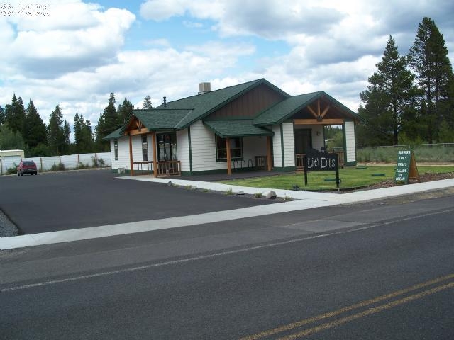
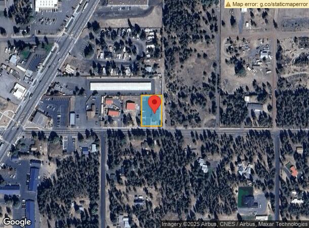
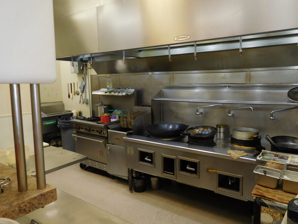
Property Record
16492 William Foss Rd, La Pine, OR 97739
NEARBY LISTINGS FOR SALE OR LEASE
Property Detail
16492 William Foss Rd
Bend-Redmond, OR
Pp2005-86
250904
PP2005-86 LOT PARCEL 3
Commercialnec
Deschutes
X
Oregon
41017C1470E
3
2024
0.46 AC
2024
Deschutes County
000201
Portland
1,974 SF
DEMOGRAPHICS near 16492 William Foss Rd
1 Mile
3 Mile
5 Mile
2024 Total Population
2,075
5,372
10,764
2029 Population
2,352
6,130
12,203
Pop Growth 2024-2029
+ 13.35%
+ 14.11%
+ 13.37%
Average Age
45
47
47
2024 Total Households
864
2,248
4,495
HH Growth 2024-2029
+ 13.54%
+ 14.28%
+ 13.55%
Median Household Inc
$39,972
$43,416
$46,865
Avg Household Size
2.30
2.30
2.30
2024 Avg HH Vehicles
2.00
2.00
2.00
Median Home Value
$252,857
$241,964
$281,847
Median Year Built
1998
1993
1992
Nearby Places
- Restaurants
- Banks
- Shops
- Fitness
- Groceries
SALE & LEASE HISTORY
LISTING DATE
SALE/LEASE

Oct 12, 2021
For Sale
Nearby Properties
Address
Land Use
TOTAL SIZE
Lot Size
Zoning
Address
Land Use
TOTAL SIZE
Lot Size
Zoning
35,466 SF
2.51 AC
LPTC
Address
Land Use
TOTAL SIZE
Lot Size
Zoning
26,194 SF
2.33 AC
LPPF
Address
Land Use
TOTAL SIZE
Lot Size
Zoning
11,100 SF
7.93 AC
LPMUC
Address
Land Use
TOTAL SIZE
Lot Size
Zoning
27,316 SF
2.67 AC
LPTC
Address
Land Use
TOTAL SIZE
Lot Size
Zoning
19.57 AC
LPMPR
Address
Land Use
TOTAL SIZE
Lot Size
Zoning
19,291 SF
1.82 AC
LPTC
Address
Land Use
TOTAL SIZE
Lot Size
Zoning
1.82 AC
LPTC
Address
Land Use
TOTAL SIZE
Lot Size
Zoning
33,206 SF
1.35 AC
LPTC
Address
Land Use
TOTAL SIZE
Lot Size
Zoning
41,616 SF
6.66 AC
LPTC
Address
Land Use
TOTAL SIZE
Lot Size
Zoning
Address
Land Use
TOTAL SIZE
Lot Size
Zoning
3,677.33 AC
F1
Address
Land Use
TOTAL SIZE
Lot Size
Zoning
17.66 AC
LPMPR
Address
Land Use
TOTAL SIZE
Lot Size
Zoning
15,263 SF
4.10 AC
RSC-C/M
Address
Land Use
TOTAL SIZE
Lot Size
Zoning
4,800 SF
2.15 AC
LPIND
Address
Land Use
TOTAL SIZE
Lot Size
Zoning
1 SF
2.25 AC
LPTC
Address
Land Use
TOTAL SIZE
Lot Size
Zoning
19,526 SF
1.85 AC
LPTC
Address
Land Use
TOTAL SIZE
Lot Size
Zoning
1.85 AC
LPTC
Address
Land Use
TOTAL SIZE
Lot Size
Zoning
5,982 SF
2.58 AC
LPTC
Address
Land Use
TOTAL SIZE
Lot Size
Zoning
25,320 SF
3.33 AC
LPMUC
Address
Land Use
TOTAL SIZE
Lot Size
Zoning
25,590 SF
0.83 AC
LPCRMU
Address
Land Use
TOTAL SIZE
Lot Size
Zoning
5 AC
RR10
Address
Land Use
TOTAL SIZE
Lot Size
Zoning
17,501 SF
5 AC
RR10
Address
Land Use
TOTAL SIZE
Lot Size
Zoning
3,994 SF
1.32 AC
LPTC
Address
Land Use
TOTAL SIZE
Lot Size
Zoning
38.73 AC
LPIND
Address
Land Use
TOTAL SIZE
Lot Size
Zoning
52,520 SF
2.17 AC
LPPF
Address
Land Use
TOTAL SIZE
Lot Size
Zoning
16,041 SF
0.59 AC
LPCRMU
Address
Land Use
TOTAL SIZE
Lot Size
Zoning
8,227 SF
0.89 AC
LPPK
Address
Land Use
TOTAL SIZE
Lot Size
Zoning
33,618 SF
5 AC
LPIND
Address
Land Use
TOTAL SIZE
Lot Size
Zoning
3,248 SF
1.60 AC
LPTC
The World's #1 Commercial Real Estate Marketplace
Connect with us
© 2025 CoStar Group
The information above has been obtained from sources believed reliable. While we do not doubt its accuracy we have not verified it and make no guarantee, warranty or representation about it. It is your responsibility to independently confirm its accuracy and completeness. Any projections, opinions, assumptions, or estimates used are for example only and do not represent the current or future performance of the property. The value of this transaction to you depends on tax and other factors which should be evaluated by your tax, financial, and legal advisors. You and your advisors should conduct a careful, independent investigation of the property to determine to your satisfaction the suitability of the property for your needs.