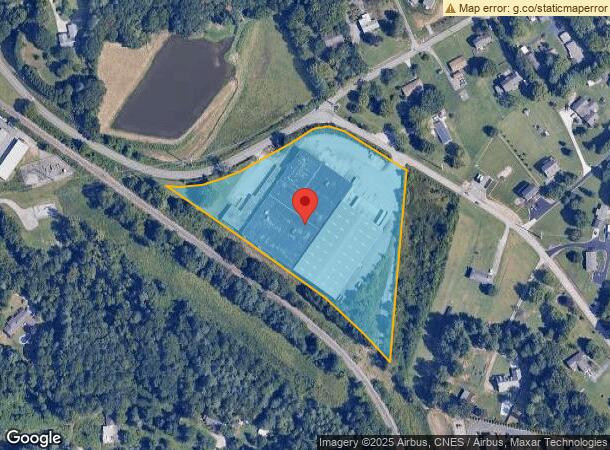
Property Record
90 Christ School Rd, Arden, NC 28704
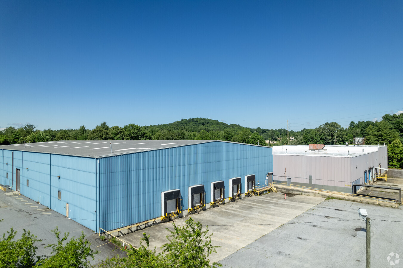
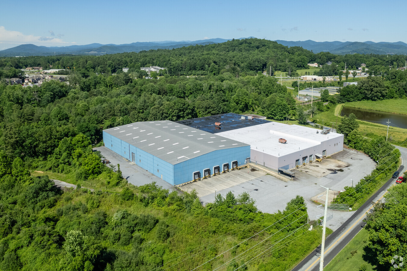

This Property Is For Sale
NEARBY LISTINGS FOR SALE OR LEASE
Property Detail
90 Christ School Rd
Asheville, NC
Plat Of J Glenn Haynes
9653-69-1988-00000
SUBDIV: BLOCK: LOT: SECTION: PLAT: 0000-0000
Industrialgeneral
Buncombe
X
North Carolina
3700965300J
1
2023
6.19 AC
2023
Buncombe County
002205
Asheville
120,416 SF
DEMOGRAPHICS near 90 Christ School Rd
1 Mile
3 Mile
5 Mile
2024 Total Population
5,337
30,404
59,645
2029 Population
5,435
31,560
61,966
Pop Growth 2024-2029
+ 1.84%
+ 3.80%
+ 3.89%
Average Age
41
42
43
2024 Total Households
2,260
12,981
25,790
HH Growth 2024-2029
+ 1.33%
+ 3.44%
+ 3.52%
Median Household Inc
$83,855
$68,064
$72,422
Avg Household Size
2.30
2.30
2.30
2024 Avg HH Vehicles
2.00
2.00
2.00
Median Home Value
$355,379
$327,551
$356,194
Median Year Built
1985
1994
1996
Nearby Places
- Restaurants
- Banks
- Shops
- Fitness
- Groceries
PUBLIC TRANSPORTATION
AIRPORT
Asheville Regional
DRIVE
WALK
Distance
Asheville Regional
6 min
3.0 mi
Freight Ports
North Charleston Terminal
DRIVE
WALK
Distance
North Charleston Terminal
277 min
246.7 mi
Nearby Properties
Address
Land Use
TOTAL SIZE
Lot Size
Zoning
Address
Land Use
TOTAL SIZE
Lot Size
Zoning
343,822 SF
58.11 AC
INST
Address
Land Use
TOTAL SIZE
Lot Size
Zoning
110,173 SF
28.13 AC
R-2
Address
Land Use
TOTAL SIZE
Lot Size
Zoning
83,129 SF
44.74 AC
EMP
Address
Land Use
TOTAL SIZE
Lot Size
Zoning
281,505 SF
38.35 AC
10000070~M
Address
Land Use
TOTAL SIZE
Lot Size
Zoning
78,745 SF
14.73 AC
HB
Address
Land Use
TOTAL SIZE
Lot Size
Zoning
85,103 SF
11.69 AC
RES EXP
Address
Land Use
TOTAL SIZE
Lot Size
Zoning
66,863 SF
7.48 AC
INST
Address
Land Use
TOTAL SIZE
Lot Size
Zoning
207,701 SF
458.72 AC
R-3
Address
Land Use
TOTAL SIZE
Lot Size
Zoning
107,408 SF
21.92 AC
EMP
Address
Land Use
TOTAL SIZE
Lot Size
Zoning
183,020 SF
22.84 AC
RM16
Address
Land Use
TOTAL SIZE
Lot Size
Zoning
198,705 SF
32.46 AC
HB
Address
Land Use
TOTAL SIZE
Lot Size
Zoning
227,740 SF
36.18 AC
INST
Address
Land Use
TOTAL SIZE
Lot Size
Zoning
73,420 SF
10.24 AC
RM16
Address
Land Use
TOTAL SIZE
Lot Size
Zoning
80,872 SF
19.85 AC
RM16
Address
Land Use
TOTAL SIZE
Lot Size
Zoning
93,715 SF
567.34 AC
AI
Address
Land Use
TOTAL SIZE
Lot Size
Zoning
71,574 SF
16 AC
RM16
Address
Land Use
TOTAL SIZE
Lot Size
Zoning
4,839 SF
9.46 AC
10002512~C
Address
Land Use
TOTAL SIZE
Lot Size
Zoning
78,783 SF
9 AC
PS
Address
Land Use
TOTAL SIZE
Lot Size
Zoning
3,466 SF
11.32 AC
10000832~M
Address
Land Use
TOTAL SIZE
Lot Size
Zoning
48,343 SF
11.67 AC
RM16
Address
Land Use
TOTAL SIZE
Lot Size
Zoning
92,772 SF
12.30 AC
R-2
Address
Land Use
TOTAL SIZE
Lot Size
Zoning
899,676 SF
46.99 AC
1006235~M-
Address
Land Use
TOTAL SIZE
Lot Size
Zoning
43,882 SF
9.71 AC
1016337~C1
Address
Land Use
TOTAL SIZE
Lot Size
Zoning
24.83 AC
1012291~M-
Address
Land Use
TOTAL SIZE
Lot Size
Zoning
87,220 SF
39.11 AC
PS
Address
Land Use
TOTAL SIZE
Lot Size
Zoning
107,698 SF
25.53 AC
PS
Address
Land Use
TOTAL SIZE
Lot Size
Zoning
208,715 SF
33.50 AC
CI
Address
Land Use
TOTAL SIZE
Lot Size
Zoning
41,104 SF
5.45 AC
CR
Address
Land Use
TOTAL SIZE
Lot Size
Zoning
76,255 SF
10.55 AC
EMP
Address
Land Use
TOTAL SIZE
Lot Size
Zoning
13,525 SF
1.84 AC
LODG EXP
The World's #1 Commercial Real Estate Marketplace
Connect with us
© 2025 CoStar Group
The information above has been obtained from sources believed reliable. While we do not doubt its accuracy we have not verified it and make no guarantee, warranty or representation about it. It is your responsibility to independently confirm its accuracy and completeness. Any projections, opinions, assumptions, or estimates used are for example only and do not represent the current or future performance of the property. The value of this transaction to you depends on tax and other factors which should be evaluated by your tax, financial, and legal advisors. You and your advisors should conduct a careful, independent investigation of the property to determine to your satisfaction the suitability of the property for your needs.