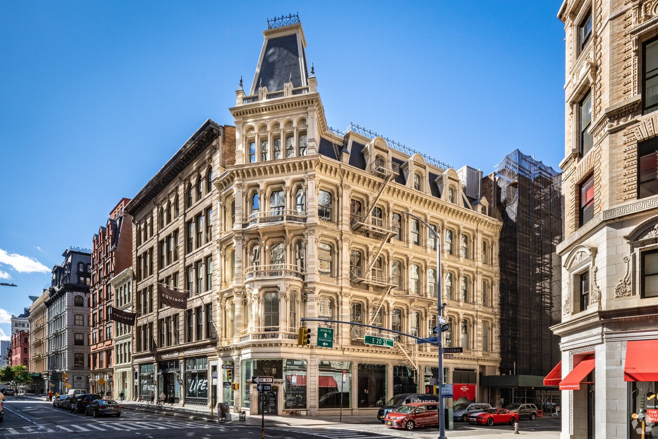
Property Record
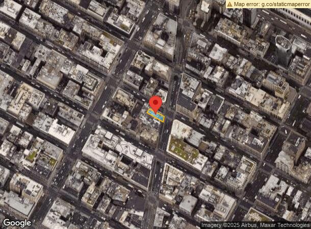
901 Broadway, New York, NY 10003

Current Lease Availabilities
NEARBY LISTINGS FOR SALE OR LEASE
Property Detail
901 Broadway
0848-0068
Manhattan
Officebuilding
New York
X
68
3604970201F
0.06 AC
2024
Gramercy Park
2024
New York City
005200
New York-Jersey City-White Plains, NY-NJ
15,245 SF
DEMOGRAPHICS near 901 Broadway
1 Mile
3 Mile
5 Mile
2024 Total Population
259,189
1,218,153
2,759,850
2029 Population
239,788
1,149,840
2,603,341
Pop Growth 2024-2029
(7.49%)
(5.61%)
(5.67%)
Average Age
40
40
39
2024 Total Households
139,448
610,322
1,254,500
HH Growth 2024-2029
(7.66%)
(5.94%)
(6.05%)
Median Household Inc
$118,450
$114,004
$95,631
Avg Household Size
1.70
1.90
2.10
2024 Avg HH Vehicles
.00
.00
.00
Median Home Value
$942,100
$957,684
$908,079
Median Year Built
1949
1962
1955
Nearby Places
- Restaurants
- Banks
- Shops
- Fitness
- Groceries
PUBLIC TRANSPORTATION
TRANSIT/SUBWAY
23 Street (N,R Line) (N - New York MTA Subway (The Subway), R - New York MTA Subway (The Subway))
DRIVE
WALK
Distance
23 Street (N,R Line) (N - New York MTA Subway (The Subway), R - New York MTA Subway (The Subway))
2 min
2 min
0.1 mi
23 Street (4,6 Line) (4 - New York MTA Subway (The Subway), 6 - New York MTA Subway (The Subway))
DRIVE
WALK
Distance
23 Street (4,6 Line) (4 - New York MTA Subway (The Subway), 6 - New York MTA Subway (The Subway))
1 min
4 min
0.2 mi
23 Street (F Line) (F - New York MTA Subway (The Subway), M - New York MTA Subway (The Subway))
DRIVE
WALK
Distance
23 Street (F Line) (F - New York MTA Subway (The Subway), M - New York MTA Subway (The Subway))
2 min
7 min
0.4 mi
14 Street (F Line) (F - New York MTA Subway (The Subway), L - New York MTA Subway (The Subway), M - New York MTA Subway (The Subway))
DRIVE
WALK
Distance
14 Street (F Line) (F - New York MTA Subway (The Subway), L - New York MTA Subway (The Subway), M - New York MTA Subway (The Subway))
1 min
10 min
0.5 mi
COMMUTER RAIL
New York Penn Station (NJT) (Montclair-Boonton Line - NJ Transit Commuter Rail (NJ Transit), Morris & Essex Gladstone Branch - NJ Transit Commuter Rail (NJ Transit), Morris & Essex Morristown Line - NJ Transit Commuter Rail (NJ Transit), North Jersey Coast Line - NJ Transit Commuter Rail (NJ Transit), Northeast Corridor Line - NJ Transit Commuter Rail (NJ Transit))
DRIVE
WALK
Distance
New York Penn Station (NJT) (Montclair-Boonton Line - NJ Transit Commuter Rail (NJ Transit), Morris & Essex Gladstone Branch - NJ Transit Commuter Rail (NJ Transit), Morris & Essex Morristown Line - NJ Transit Commuter Rail (NJ Transit), North Jersey Coast Line - NJ Transit Commuter Rail (NJ Transit), Northeast Corridor Line - NJ Transit Commuter Rail (NJ Transit))
4 min
17 min
0.9 mi
New York Penn Station (LIRR) (Babylon Branch - Long Island Rail Road, Far Rockaway Branch - Long Island Rail Road, Hempstead Branch - Long Island Rail Road, Long Beach Branch - Long Island Rail Road, Montauk Branch - Long Island Rail Road, Port Jefferson Branch - Long Island Rail Road, Port Washington Branch - Long Island Rail Road, Ronkonkoma Branch - Long Island Rail Road, West Hempstead Branch - Long Island Rail Road)
DRIVE
WALK
Distance
New York Penn Station (LIRR) (Babylon Branch - Long Island Rail Road, Far Rockaway Branch - Long Island Rail Road, Hempstead Branch - Long Island Rail Road, Long Beach Branch - Long Island Rail Road, Montauk Branch - Long Island Rail Road, Port Jefferson Branch - Long Island Rail Road, Port Washington Branch - Long Island Rail Road, Ronkonkoma Branch - Long Island Rail Road, West Hempstead Branch - Long Island Rail Road)
4 min
17 min
0.9 mi
AIRPORT
Newark Liberty International
DRIVE
WALK
Distance
Newark Liberty International
24 min
13.6 mi
John F. Kennedy International
DRIVE
WALK
Distance
John F. Kennedy International
23 min
16.3 mi
Westchester County
DRIVE
WALK
Distance
Westchester County
47 min
34.4 mi
Nearby Properties
Address
Land Use
TOTAL SIZE
Lot Size
Zoning
Address
Land Use
TOTAL SIZE
Lot Size
Zoning
8,966,500 SF
19.14 AC
C6-4
Address
Land Use
TOTAL SIZE
Lot Size
Zoning
4,060,596 SF
22.09 AC
M2-3
Address
Land Use
TOTAL SIZE
Lot Size
Zoning
1,783,434 SF
1.94 AC
C5-3
Address
Land Use
TOTAL SIZE
Lot Size
Zoning
2,245,112 SF
2.02 AC
C6-6
Address
Land Use
TOTAL SIZE
Lot Size
Zoning
2,521,850 SF
1.59 AC
C6-4
Address
Land Use
TOTAL SIZE
Lot Size
Zoning
2,221,336 SF
1.55 AC
C6-4
Address
Land Use
TOTAL SIZE
Lot Size
Zoning
2,161,994 SF
3.79 AC
M1-5
Address
Land Use
TOTAL SIZE
Lot Size
Zoning
2,636,182 SF
2.35 AC
C65.5
Address
Land Use
TOTAL SIZE
Lot Size
Zoning
2,354,289 SF
3.96 AC
C6-4
Address
Land Use
TOTAL SIZE
Lot Size
Zoning
1,678,135 SF
1.01 AC
C5-3
Address
Land Use
TOTAL SIZE
Lot Size
Zoning
2,734,038 SF
4.24 AC
C52.5
Address
Land Use
TOTAL SIZE
Lot Size
Zoning
1,897,491 SF
2.06 AC
C52.5
Address
Land Use
TOTAL SIZE
Lot Size
Zoning
1,638,259 SF
1.42 AC
C52.5
Address
Land Use
TOTAL SIZE
Lot Size
Zoning
2,812,739 SF
2.10 AC
C5-3
Address
Land Use
TOTAL SIZE
Lot Size
Zoning
2,360,627 SF
2.08 AC
C6-7
Address
Land Use
TOTAL SIZE
Lot Size
Zoning
1,586,876 SF
1.87 AC
C5-3
Address
Land Use
TOTAL SIZE
Lot Size
Zoning
1,048,620 SF
5.67 AC
C6-4
Address
Land Use
TOTAL SIZE
Lot Size
Zoning
1,962,900 SF
1.89 AC
C66.5
Address
Land Use
TOTAL SIZE
Lot Size
Zoning
1,842,991 SF
2.08 AC
C66.5
Address
Land Use
TOTAL SIZE
Lot Size
Zoning
1,178,640 SF
0.92 AC
C6-4
Address
Land Use
TOTAL SIZE
Lot Size
Zoning
2,535,958 SF
2.94 AC
C6-4
Address
Land Use
TOTAL SIZE
Lot Size
Zoning
1,751,641 SF
1.84 AC
C6-4
Address
Land Use
TOTAL SIZE
Lot Size
Zoning
6,877 SF
27.74 AC
R-1E
Address
Land Use
TOTAL SIZE
Lot Size
Zoning
Address
Land Use
TOTAL SIZE
Lot Size
Zoning
1,642,675 SF
1.05 AC
C6-7
Address
Land Use
TOTAL SIZE
Lot Size
Zoning
2.38 AC
Address
Land Use
TOTAL SIZE
Lot Size
Zoning
1.75 AC
Address
Land Use
TOTAL SIZE
Lot Size
Zoning
1,805,894 SF
1.42 AC
C6-4
Address
Land Use
TOTAL SIZE
Lot Size
Zoning
264,420 SF
7.26 AC
C4-7
Address
Land Use
TOTAL SIZE
Lot Size
Zoning
2,157,862 SF
2.23 AC
BPC
The World's #1 Commercial Real Estate Marketplace
Connect with us
© 2025 CoStar Group
The information above has been obtained from sources believed reliable. While we do not doubt its accuracy we have not verified it and make no guarantee, warranty or representation about it. It is your responsibility to independently confirm its accuracy and completeness. Any projections, opinions, assumptions, or estimates used are for example only and do not represent the current or future performance of the property. The value of this transaction to you depends on tax and other factors which should be evaluated by your tax, financial, and legal advisors. You and your advisors should conduct a careful, independent investigation of the property to determine to your satisfaction the suitability of the property for your needs.