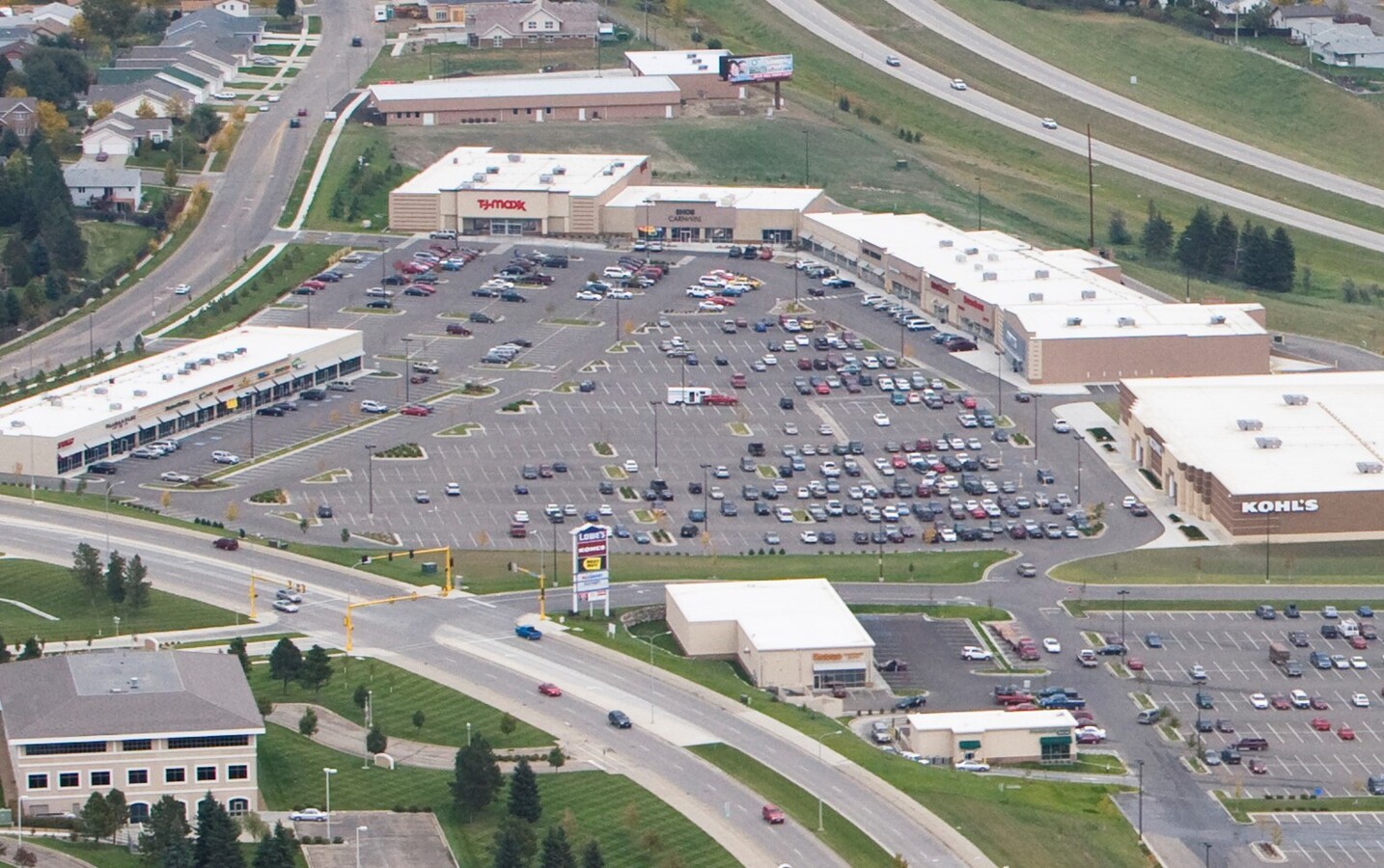
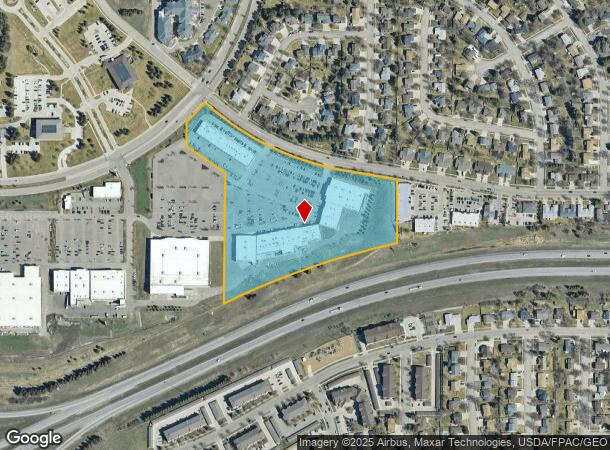
Property Record
901 W Interstate Ave, Bismarck, ND 58503
NEARBY LISTINGS FOR SALE OR LEASE
Property Detail
901 W Interstate Ave
Bismarck, ND
Pinehurst Square Addition
0756-001-200
PINEHURST SQUARE ADDITION LOT 7
Regionalshoppingcenterormallwithanchorstore
Burleigh
X
North Dakota
38015C0785E
7
2024
13.88 AC
2024
North Bismarck
011103
Other Market Areas
38,467 SF
DEMOGRAPHICS near 901 W Interstate Ave
1 Mile
3 Mile
5 Mile
2024 Total Population
10,053
60,489
102,620
2029 Population
10,352
62,491
105,967
Pop Growth 2024-2029
+ 2.97%
+ 3.31%
+ 3.26%
Average Age
42
41
40
2024 Total Households
4,330
26,747
43,770
HH Growth 2024-2029
+ 3.05%
+ 3.35%
+ 3.28%
Median Household Inc
$63,190
$63,107
$67,824
Avg Household Size
2.20
2.20
2.20
2024 Avg HH Vehicles
2.00
2.00
2.00
Median Home Value
$281,298
$270,228
$261,533
Median Year Built
1984
1982
1985
Nearby Places
- Restaurants
- Banks
- Shops
- Fitness
- Groceries
PUBLIC TRANSPORTATION
AIRPORT
Bismarck Municipal
DRIVE
WALK
Distance
Bismarck Municipal
22 min
7.3 mi
Freight Ports
Port Milwaukee
DRIVE
WALK
Distance
Port Milwaukee
825 min
765.9 mi
SALE & LEASE HISTORY
LISTING DATE
SALE/LEASE

Sep 25, 2016
For Lease
Nearby Properties
Address
Land Use
TOTAL SIZE
Lot Size
Zoning
Address
Land Use
TOTAL SIZE
Lot Size
Zoning
45.23 AC
CG
Address
Land Use
TOTAL SIZE
Lot Size
Zoning
13.47 AC
PUD
Address
Land Use
TOTAL SIZE
Lot Size
Zoning
93,860 SF
1.44 AC
HM
Address
Land Use
TOTAL SIZE
Lot Size
Zoning
28.06 AC
CG
Address
Land Use
TOTAL SIZE
Lot Size
Zoning
18.70 AC
RM15
Address
Land Use
TOTAL SIZE
Lot Size
Zoning
70,182 SF
3.83 AC
PUD
Address
Land Use
TOTAL SIZE
Lot Size
Zoning
27.48 AC
CG
Address
Land Use
TOTAL SIZE
Lot Size
Zoning
81,092 SF
4.17 AC
HM
Address
Land Use
TOTAL SIZE
Lot Size
Zoning
7.67 AC
CG
Address
Land Use
TOTAL SIZE
Lot Size
Zoning
31,202 SF
9.05 AC
RM30
Address
Land Use
TOTAL SIZE
Lot Size
Zoning
20.87 AC
CG
Address
Land Use
TOTAL SIZE
Lot Size
Zoning
65,001 SF
9.88 AC
RT
Address
Land Use
TOTAL SIZE
Lot Size
Zoning
16.12 AC
CG
Address
Land Use
TOTAL SIZE
Lot Size
Zoning
38,275 SF
10.53 AC
RM30
Address
Land Use
TOTAL SIZE
Lot Size
Zoning
39,771 SF
9.65 AC
CG
Address
Land Use
TOTAL SIZE
Lot Size
Zoning
27,639 SF
4.28 AC
RT
Address
Land Use
TOTAL SIZE
Lot Size
Zoning
7.83 AC
RM20
Address
Land Use
TOTAL SIZE
Lot Size
Zoning
52,718 SF
2.67 AC
RM15
Address
Land Use
TOTAL SIZE
Lot Size
Zoning
13.98 AC
CG
Address
Land Use
TOTAL SIZE
Lot Size
Zoning
74,564 SF
6.67 AC
RT
Address
Land Use
TOTAL SIZE
Lot Size
Zoning
51,723 SF
1.69 AC
HM
Address
Land Use
TOTAL SIZE
Lot Size
Zoning
10.84 AC
CG
Address
Land Use
TOTAL SIZE
Lot Size
Zoning
8,685 SF
12.51 AC
CG
Address
Land Use
TOTAL SIZE
Lot Size
Zoning
57,580 SF
8.85 AC
CG
Address
Land Use
TOTAL SIZE
Lot Size
Zoning
40,647 SF
2.67 AC
PUD
Address
Land Use
TOTAL SIZE
Lot Size
Zoning
3.90 AC
RM30
Address
Land Use
TOTAL SIZE
Lot Size
Zoning
62,652 SF
2.34 AC
HM
Address
Land Use
TOTAL SIZE
Lot Size
Zoning
99,684 SF
2.33 AC
MA
Address
Land Use
TOTAL SIZE
Lot Size
Zoning
74,250 SF
5.63 AC
PUD
The World's #1 Commercial Real Estate Marketplace
Connect with us
© 2025 CoStar Group
The information above has been obtained from sources believed reliable. While we do not doubt its accuracy we have not verified it and make no guarantee, warranty or representation about it. It is your responsibility to independently confirm its accuracy and completeness. Any projections, opinions, assumptions, or estimates used are for example only and do not represent the current or future performance of the property. The value of this transaction to you depends on tax and other factors which should be evaluated by your tax, financial, and legal advisors. You and your advisors should conduct a careful, independent investigation of the property to determine to your satisfaction the suitability of the property for your needs.