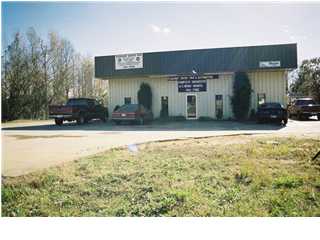
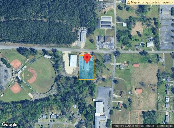
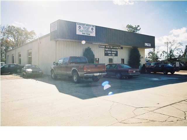
Property Record
909 4Th St, Pleasant Grove, AL 35127
NEARBY LISTINGS FOR SALE OR LEASE
Property Detail
909 4Th St
30-00-05-3-002-028.000
COM SW COR OF E 1/2 OF NE4 OF SW4 OF SEC 5 TP 18S R 4W TH N 348.2 FT E 219.9 FT TO POB TH N 270.4 FT TH E 167.6 FT TH S 266.3 FT TH W 156.6 FT TO POB
Autorepair
Jefferson
X
Alabama
01073C0526G
1.06 AC
2023
Bessemer
2024
Birmingham
012307
Birmingham-Hoover, AL
6,250 SF
DEMOGRAPHICS near 909 4Th St
1 Mile
3 Mile
5 Mile
2024 Total Population
2,752
15,884
56,537
2029 Population
2,697
15,571
55,950
Pop Growth 2024-2029
(2.00%)
(1.97%)
(1.04%)
Average Age
40
42
41
2024 Total Households
1,044
6,068
22,384
HH Growth 2024-2029
(2.01%)
(2.03%)
(1.12%)
Median Household Inc
$65,046
$64,767
$50,012
Avg Household Size
2.60
2.50
2.40
2024 Avg HH Vehicles
2.00
2.00
2.00
Median Home Value
$157,452
$160,406
$120,570
Median Year Built
1977
1979
1966
Nearby Places
- Restaurants
- Banks
- Shops
- Fitness
- Groceries
PUBLIC TRANSPORTATION
AIRPORT
Birmingham-Shuttlesworth International
DRIVE
WALK
Distance
Birmingham-Shuttlesworth International
28 min
16.5 mi
Freight Ports
Port of Mobile
DRIVE
WALK
Distance
Port of Mobile
294 min
246.5 mi
Nearby Properties
Address
Land Use
TOTAL SIZE
Lot Size
Zoning
Address
Land Use
TOTAL SIZE
Lot Size
Zoning
2,573,547 SF
112 AC
I2
Address
Land Use
TOTAL SIZE
Lot Size
Zoning
195,495 SF
28.97 AC
B3
Address
Land Use
TOTAL SIZE
Lot Size
Zoning
110,770 SF
7.20 AC
R3
Address
Land Use
TOTAL SIZE
Lot Size
Zoning
218,210 SF
11.24 AC
CM-2
Address
Land Use
TOTAL SIZE
Lot Size
Zoning
66,935 SF
1.99 AC
B2
Address
Land Use
TOTAL SIZE
Lot Size
Zoning
1,437,077 SF
I2
Address
Land Use
TOTAL SIZE
Lot Size
Zoning
94,026 SF
4.90 AC
I2R2
Address
Land Use
TOTAL SIZE
Lot Size
Zoning
1,244,986 SF
I2
Address
Land Use
TOTAL SIZE
Lot Size
Zoning
130,563 SF
I3
Address
Land Use
TOTAL SIZE
Lot Size
Zoning
36,546 SF
6.30 AC
R3
Address
Land Use
TOTAL SIZE
Lot Size
Zoning
30,332 SF
2.34 AC
B-2
Address
Land Use
TOTAL SIZE
Lot Size
Zoning
27,635 SF
3.70 AC
R1-R
Address
Land Use
TOTAL SIZE
Lot Size
Zoning
28,221 SF
I2
Address
Land Use
TOTAL SIZE
Lot Size
Zoning
59,834 SF
11.67 AC
I2
Address
Land Use
TOTAL SIZE
Lot Size
Zoning
16,579 SF
1.58 AC
B2
Address
Land Use
TOTAL SIZE
Lot Size
Zoning
25,944 SF
3.57 AC
I3
Address
Land Use
TOTAL SIZE
Lot Size
Zoning
159 AC
I2
Address
Land Use
TOTAL SIZE
Lot Size
Zoning
41,462 SF
2.35 AC
B1
Address
Land Use
TOTAL SIZE
Lot Size
Zoning
15,456 SF
I2
Address
Land Use
TOTAL SIZE
Lot Size
Zoning
21,756 SF
1.51 AC
B2
Address
Land Use
TOTAL SIZE
Lot Size
Zoning
4,653 SF
160 AC
I2
Address
Land Use
TOTAL SIZE
Lot Size
Zoning
19,320 SF
1.95 AC
B2
Address
Land Use
TOTAL SIZE
Lot Size
Zoning
25,590 SF
1.13 AC
I
Address
Land Use
TOTAL SIZE
Lot Size
Zoning
9,993 SF
2.75 AC
I-1
Address
Land Use
TOTAL SIZE
Lot Size
Zoning
35,600 SF
60 AC
I2
Address
Land Use
TOTAL SIZE
Lot Size
Zoning
35,110 SF
10 AC
R2
Address
Land Use
TOTAL SIZE
Lot Size
Zoning
15,360 SF
0.49 AC
I3
Address
Land Use
TOTAL SIZE
Lot Size
Zoning
17,243 SF
2 AC
I
Address
Land Use
TOTAL SIZE
Lot Size
Zoning
24,474 SF
2.20 AC
R3
Address
Land Use
TOTAL SIZE
Lot Size
Zoning
101 AC
I2
The World's #1 Commercial Real Estate Marketplace
Connect with us
© 2025 CoStar Group
The information above has been obtained from sources believed reliable. While we do not doubt its accuracy we have not verified it and make no guarantee, warranty or representation about it. It is your responsibility to independently confirm its accuracy and completeness. Any projections, opinions, assumptions, or estimates used are for example only and do not represent the current or future performance of the property. The value of this transaction to you depends on tax and other factors which should be evaluated by your tax, financial, and legal advisors. You and your advisors should conduct a careful, independent investigation of the property to determine to your satisfaction the suitability of the property for your needs.