Property Record
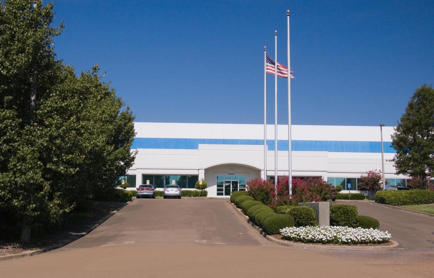
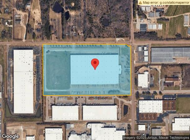
9105 Hacks Cross Rd, Olive Branch, MS 38654


Current Lease Availabilities
NEARBY LISTINGS FOR SALE OR LEASE
Property Detail
9105 Hacks Cross Rd
Memphis, TN-MS-AR
Williams Industrial S-D
1066140000000103
WILLIAMS INDUSTRIAL S-D RESUB LOT 1 LOT 1A
Warehouse
DeSoto
X
Mississippi
28033C0110H
1
2024
43.20 AC
2024
DeSoto
070812
Memphis
596,400 SF
DEMOGRAPHICS near 9105 Hacks Cross Rd
1 Mile
3 Mile
5 Mile
2024 Total Population
1,951
46,839
113,896
2029 Population
1,927
47,250
115,196
Pop Growth 2024-2029
(1.23%)
+ 0.88%
+ 1.14%
Average Age
35
38
37
2024 Total Households
762
17,157
42,841
HH Growth 2024-2029
(1.44%)
+ 0.92%
+ 1.04%
Median Household Inc
$39,484
$75,977
$72,980
Avg Household Size
2.60
2.70
2.60
2024 Avg HH Vehicles
2.00
2.00
2.00
Median Home Value
$235,061
$192,033
$204,940
Median Year Built
1997
1996
1993
Nearby Places
- Restaurants
- Banks
- Shops
- Fitness
- Groceries
PUBLIC TRANSPORTATION
AIRPORT
Memphis International
DRIVE
WALK
Distance
Memphis International
24 min
14.3 mi
Freight Ports
Port of Shreveport
DRIVE
WALK
Distance
Port of Shreveport
429 min
388.1 mi
Nearby Properties
Address
Land Use
TOTAL SIZE
Lot Size
Zoning
Address
Land Use
TOTAL SIZE
Lot Size
Zoning
1,063,915 SF
74.33 AC
M-2
Address
Land Use
TOTAL SIZE
Lot Size
Zoning
830,732 SF
41.14 AC
M-1
Address
Land Use
TOTAL SIZE
Lot Size
Zoning
52,688 SF
24.38 AC
CA
Address
Land Use
TOTAL SIZE
Lot Size
Zoning
38,566 SF
27.90 AC
CA
Address
Land Use
TOTAL SIZE
Lot Size
Zoning
10,128 SF
23.35 AC
CA
Address
Land Use
TOTAL SIZE
Lot Size
Zoning
1,151,180 SF
68.41 AC
M-1
Address
Land Use
TOTAL SIZE
Lot Size
Zoning
990,181 SF
55.79 AC
M-1
Address
Land Use
TOTAL SIZE
Lot Size
Zoning
996,105 SF
60.30 AC
PUD
Address
Land Use
TOTAL SIZE
Lot Size
Zoning
1,103,356 SF
60.98 AC
M-1
Address
Land Use
TOTAL SIZE
Lot Size
Zoning
869,876 SF
43.85 AC
M-1
Address
Land Use
TOTAL SIZE
Lot Size
Zoning
616,255 SF
39.07 AC
M-1
Address
Land Use
TOTAL SIZE
Lot Size
Zoning
1,299,800 SF
50.22 AC
M-1
Address
Land Use
TOTAL SIZE
Lot Size
Zoning
642,804 SF
67.55 AC
M-1
Address
Land Use
TOTAL SIZE
Lot Size
Zoning
728,940 SF
66.85 AC
M-1
Address
Land Use
TOTAL SIZE
Lot Size
Zoning
928,416 SF
42.73 AC
PB
Address
Land Use
TOTAL SIZE
Lot Size
Zoning
814,637 SF
38.72 AC
PB
Address
Land Use
TOTAL SIZE
Lot Size
Zoning
617,288 SF
61.92 AC
PUD
Address
Land Use
TOTAL SIZE
Lot Size
Zoning
426,759 SF
40.66 AC
M-1
Address
Land Use
TOTAL SIZE
Lot Size
Zoning
1,085,489 SF
57.74 AC
PB
Address
Land Use
TOTAL SIZE
Lot Size
Zoning
65,282 SF
15.92 AC
CA
Address
Land Use
TOTAL SIZE
Lot Size
Zoning
861,020 SF
43.13 AC
M-1
Address
Land Use
TOTAL SIZE
Lot Size
Zoning
28,120 SF
12.75 AC
CA
Address
Land Use
TOTAL SIZE
Lot Size
Zoning
210,161 SF
14.86 AC
R-6
Address
Land Use
TOTAL SIZE
Lot Size
Zoning
81,018 SF
18.09 AC
CA
Address
Land Use
TOTAL SIZE
Lot Size
Zoning
58,235 SF
7.62 AC
CA
Address
Land Use
TOTAL SIZE
Lot Size
Zoning
28.41 AC
PB
Address
Land Use
TOTAL SIZE
Lot Size
Zoning
2,035 SF
28.60 AC
R-8
Address
Land Use
TOTAL SIZE
Lot Size
Zoning
159,319 SF
14.70 AC
CMU-2
Address
Land Use
TOTAL SIZE
Lot Size
Zoning
69,571 SF
16.22 AC
CA
Address
Land Use
TOTAL SIZE
Lot Size
Zoning
606,459 SF
40.17 AC
M-1
The World's #1 Commercial Real Estate Marketplace
Connect with us
© 2025 CoStar Group
The information above has been obtained from sources believed reliable. While we do not doubt its accuracy we have not verified it and make no guarantee, warranty or representation about it. It is your responsibility to independently confirm its accuracy and completeness. Any projections, opinions, assumptions, or estimates used are for example only and do not represent the current or future performance of the property. The value of this transaction to you depends on tax and other factors which should be evaluated by your tax, financial, and legal advisors. You and your advisors should conduct a careful, independent investigation of the property to determine to your satisfaction the suitability of the property for your needs.