Property Record
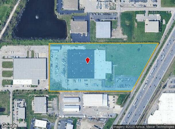
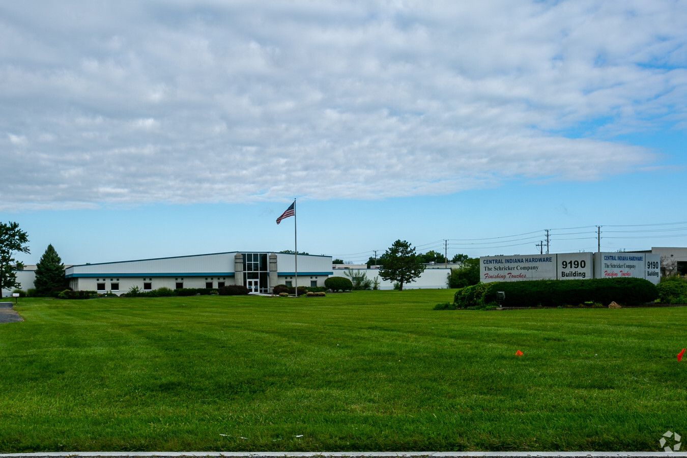
9190 Corporation Dr, Indianapolis, IN 46256

NEARBY LISTINGS FOR SALE OR LEASE
Property Detail
9190 Corporation Dr
49-02-14-113-009.000-400
PT S1/2 NE1/4 S14 T17 R4 BEG 718.29 W OF SE COR P.O.B. W865 N500 E1146.45 SW574.13 TO BEG 11.544AC
Lightindustrial
Marion
X
Indiana
18097C0066F
11.54 AC
2023
Castleton
2023
Indianapolis
330103
Indianapolis-Carmel-Anderson, IN
133,131 SF
DEMOGRAPHICS near 9190 Corporation Dr
1 Mile
3 Mile
5 Mile
2024 Total Population
5,134
58,217
154,841
2029 Population
5,055
60,562
162,308
Pop Growth 2024-2029
(1.54%)
+ 4.03%
+ 4.82%
Average Age
41
40
40
2024 Total Households
2,749
26,747
65,357
HH Growth 2024-2029
(1.49%)
+ 3.61%
+ 4.36%
Median Household Inc
$56,353
$74,913
$90,835
Avg Household Size
1.80
2.10
2.30
2024 Avg HH Vehicles
1.00
2.00
2.00
Median Home Value
$167,609
$254,987
$292,608
Median Year Built
1985
1987
1989
Nearby Places
- Restaurants
- Banks
- Shops
- Fitness
- Groceries
PUBLIC TRANSPORTATION
AIRPORT
Indianapolis International
DRIVE
WALK
Distance
Indianapolis International
48 min
28.6 mi
Freight Ports
Port of Toledo
DRIVE
WALK
Distance
Port of Toledo
250 min
212.1 mi
SALE & LEASE HISTORY
LISTING DATE
SALE/LEASE

Sep 24, 2016
For Lease
Nearby Properties
Address
Land Use
TOTAL SIZE
Lot Size
Zoning
Address
Land Use
TOTAL SIZE
Lot Size
Zoning
366,825 SF
26.60 AC
ZO01
Address
Land Use
TOTAL SIZE
Lot Size
Zoning
8,551 SF
45.92 AC
ZO01
Address
Land Use
TOTAL SIZE
Lot Size
Zoning
21,742 SF
39.35 AC
ZO01
Address
Land Use
TOTAL SIZE
Lot Size
Zoning
16,704 SF
109.83 AC
ZO01
Address
Land Use
TOTAL SIZE
Lot Size
Zoning
22,081 SF
27.39 AC
ZO01
Address
Land Use
TOTAL SIZE
Lot Size
Zoning
10,911 SF
11.56 AC
ZO01
Address
Land Use
TOTAL SIZE
Lot Size
Zoning
4,246 SF
89.83 AC
ZO01
Address
Land Use
TOTAL SIZE
Lot Size
Zoning
683,795 SF
25.53 AC
Address
Land Use
TOTAL SIZE
Lot Size
Zoning
555,234 SF
36.07 AC
Address
Land Use
TOTAL SIZE
Lot Size
Zoning
328,241 SF
91.83 AC
Address
Land Use
TOTAL SIZE
Lot Size
Zoning
5,314 SF
13.92 AC
ZO01
Address
Land Use
TOTAL SIZE
Lot Size
Zoning
372,138 SF
20.71 AC
Address
Land Use
TOTAL SIZE
Lot Size
Zoning
363,408 SF
30.78 AC
Address
Land Use
TOTAL SIZE
Lot Size
Zoning
3,023 SF
10.33 AC
ZO01
Address
Land Use
TOTAL SIZE
Lot Size
Zoning
125.31 AC
Address
Land Use
TOTAL SIZE
Lot Size
Zoning
290,488 SF
13.72 AC
Address
Land Use
TOTAL SIZE
Lot Size
Zoning
176,103 SF
0.90 AC
Address
Land Use
TOTAL SIZE
Lot Size
Zoning
6,252 SF
52.04 AC
ZO01
Address
Land Use
TOTAL SIZE
Lot Size
Zoning
289,664 SF
35.22 AC
Address
Land Use
TOTAL SIZE
Lot Size
Zoning
217,633 SF
78.75 AC
Address
Land Use
TOTAL SIZE
Lot Size
Zoning
6,229 SF
36.20 AC
ZO01
Address
Land Use
TOTAL SIZE
Lot Size
Zoning
224,368 SF
0.73 AC
Address
Land Use
TOTAL SIZE
Lot Size
Zoning
6,366 SF
19.40 AC
ZO01
Address
Land Use
TOTAL SIZE
Lot Size
Zoning
24,192 SF
5.92 AC
Address
Land Use
TOTAL SIZE
Lot Size
Zoning
288,939 SF
34.29 AC
Address
Land Use
TOTAL SIZE
Lot Size
Zoning
308,854 SF
13.64 AC
Address
Land Use
TOTAL SIZE
Lot Size
Zoning
151,823 SF
57.54 AC
ZO01
Address
Land Use
TOTAL SIZE
Lot Size
Zoning
91,717 SF
37.30 AC
Address
Land Use
TOTAL SIZE
Lot Size
Zoning
118,729 SF
13.39 AC
ZO01
Address
Land Use
TOTAL SIZE
Lot Size
Zoning
167,734 SF
3.69 AC
The World's #1 Commercial Real Estate Marketplace
Connect with us
© 2025 CoStar Group
The information above has been obtained from sources believed reliable. While we do not doubt its accuracy we have not verified it and make no guarantee, warranty or representation about it. It is your responsibility to independently confirm its accuracy and completeness. Any projections, opinions, assumptions, or estimates used are for example only and do not represent the current or future performance of the property. The value of this transaction to you depends on tax and other factors which should be evaluated by your tax, financial, and legal advisors. You and your advisors should conduct a careful, independent investigation of the property to determine to your satisfaction the suitability of the property for your needs.