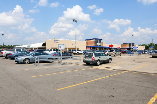
Property Record
9200 N Main St, Englewood, OH 45322

NEARBY LISTINGS FOR SALE OR LEASE
Property Detail
9200 N Main St
M57-00821-0001
Meijer
Departmentstore
OUTLOT 6 VALVOLINE
X
Montgomery
39113C0132E
Ohio
2024
32.06 AC
2025
North Dayton
125102
Cincinnati/Dayton
200,716 SF
Dayton, OH
DEMOGRAPHICS near 9200 N Main St
1 Mile
3 Mile
5 Mile
2024 Total Population
3,346
32,695
87,353
2029 Population
3,283
32,081
85,984
Pop Growth 2024-2029
(1.88%)
(1.88%)
(1.57%)
Average Age
44
43
42
2024 Total Households
1,386
13,827
37,856
HH Growth 2024-2029
(1.95%)
(1.89%)
(1.58%)
Median Household Inc
$78,303
$66,391
$58,491
Avg Household Size
2.30
2.30
2.20
2024 Avg HH Vehicles
2.00
2.00
2.00
Median Home Value
$184,592
$167,944
$155,561
Median Year Built
1971
1972
1967
Nearby Places
Map Layers
Map Styles
 Street
 Aerial
- Restaurants
- Banks
- Shops
- Fitness
- Groceries
PUBLIC TRANSPORTATION
AIRPORT
James M Cox Dayton International
DRIVE
WALK
Distance
James M Cox Dayton International
13 min
7.2 mi
Nearby Properties
Address
Land Use
TOTAL SIZE
Lot Size
Zoning
Address
Land Use
TOTAL SIZE
Lot Size
Zoning
586,025 SF
194.14 AC
Address
Land Use
TOTAL SIZE
Lot Size
Zoning
1,841,033 SF
129.70 AC
Address
Land Use
TOTAL SIZE
Lot Size
Zoning
562,815 SF
41.46 AC
Address
Land Use
TOTAL SIZE
Lot Size
Zoning
1,059,902 SF
56.13 AC
Address
Land Use
TOTAL SIZE
Lot Size
Zoning
664,824 SF
1,128.84 AC
Address
Land Use
TOTAL SIZE
Lot Size
Zoning
730,000 SF
56.40 AC
Address
Land Use
TOTAL SIZE
Lot Size
Zoning
730,000 SF
56.40 AC
Address
Land Use
TOTAL SIZE
Lot Size
Zoning
12,660 SF
20.22 AC
Address
Land Use
TOTAL SIZE
Lot Size
Zoning
25.82 AC
Address
Land Use
TOTAL SIZE
Lot Size
Zoning
92,192 SF
41.46 AC
Address
Land Use
TOTAL SIZE
Lot Size
Zoning
558,933 SF
19.55 AC
Address
Land Use
TOTAL SIZE
Lot Size
Zoning
222,799 SF
13.74 AC
Address
Land Use
TOTAL SIZE
Lot Size
Zoning
0.45 AC
Address
Land Use
TOTAL SIZE
Lot Size
Zoning
12,924 SF
51.34 AC
Address
Land Use
TOTAL SIZE
Lot Size
Zoning
252,449 SF
19.41 AC
Address
Land Use
TOTAL SIZE
Lot Size
Zoning
92,440 SF
3.01 AC
Address
Land Use
TOTAL SIZE
Lot Size
Zoning
196,976 SF
20.24 AC
Address
Land Use
TOTAL SIZE
Lot Size
Zoning
82,155 SF
7.85 AC
Address
Land Use
TOTAL SIZE
Lot Size
Zoning
212,060 SF
29.77 AC
Address
Land Use
TOTAL SIZE
Lot Size
Zoning
4.37 AC
Address
Land Use
TOTAL SIZE
Lot Size
Zoning
46,592 SF
5.32 AC
Address
Land Use
TOTAL SIZE
Lot Size
Zoning
125,183 SF
10.51 AC
Address
Land Use
TOTAL SIZE
Lot Size
Zoning
165,018 SF
19.77 AC
Address
Land Use
TOTAL SIZE
Lot Size
Zoning
164,834 SF
24.53 AC
Address
Land Use
TOTAL SIZE
Lot Size
Zoning
13 AC
Address
Land Use
TOTAL SIZE
Lot Size
Zoning
107,907 SF
20.54 AC
Address
Land Use
TOTAL SIZE
Lot Size
Zoning
115,800 SF
14.51 AC
Address
Land Use
TOTAL SIZE
Lot Size
Zoning
2,520 SF
11.66 AC
Address
Land Use
TOTAL SIZE
Lot Size
Zoning
88,642 SF
11.85 AC
The World's #1 Commercial Real Estate Marketplace
Connect with us
© 2026 CoStar Group
The information above has been obtained from sources believed reliable. While we do not doubt its accuracy we have not verified it and make no guarantee, warranty or representation about it. It is your responsibility to independently confirm its accuracy and completeness. Any projections, opinions, assumptions, or estimates used are for example only and do not represent the current or future performance of the property. The value of this transaction to you depends on tax and other factors which should be evaluated by your tax, financial, and legal advisors. You and your advisors should conduct a careful, independent investigation of the property to determine to your satisfaction the suitability of the property for your needs.