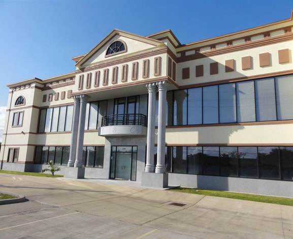
Property Record
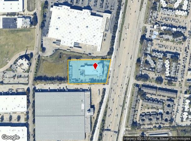
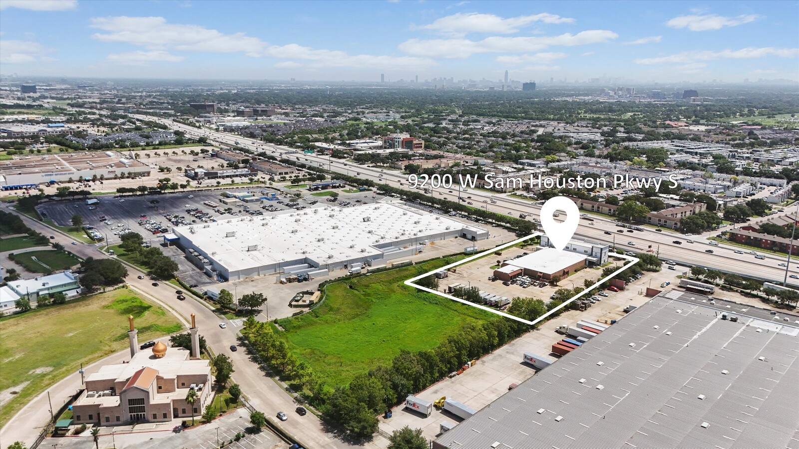
9200 W Sam Houston Pkwy S, Houston, TX 77099

Current Lease Availabilities
NEARBY LISTINGS FOR SALE OR LEASE
Property Detail
9200 W Sam Houston Pkwy S
1174290010001
West Belt Plaza
Officebuilding
RES D1 BLK 1 WEST BELT PLAZA SEC 2
X
Harris
48201C0845M
Texas
2023
2.63 AC
2023
Sugar Land
453202
Houston
23,416 SF
Houston-The Woodlands-Sugar Land, TX
DEMOGRAPHICS near 9200 W Sam Houston Pkwy S
1 Mile
3 Mile
5 Mile
2024 Total Population
37,131
206,402
525,485
2029 Population
37,937
212,445
547,688
Pop Growth 2024-2029
+ 2.17%
+ 2.93%
+ 4.23%
Average Age
32
36
36
2024 Total Households
13,363
71,185
193,160
HH Growth 2024-2029
+ 2.04%
+ 3.11%
+ 4.20%
Median Household Inc
$31,226
$40,483
$44,507
Avg Household Size
2.70
2.80
2.60
2024 Avg HH Vehicles
1.00
2.00
2.00
Median Home Value
$154,157
$172,560
$206,642
Median Year Built
1982
1978
1980
Nearby Places
- Restaurants
- Banks
- Shops
- Fitness
- Groceries
PUBLIC TRANSPORTATION
AIRPORT
William P Hobby
DRIVE
WALK
Distance
William P Hobby
35 min
22.6 mi
George Bush Intcntl/Houston
DRIVE
WALK
Distance
George Bush Intcntl/Houston
42 min
34.8 mi
Freight Ports
Port of Houston
DRIVE
WALK
Distance
Port of Houston
36 min
21.9 mi
Nearby Properties
Address
Land Use
TOTAL SIZE
Lot Size
Zoning
Address
Land Use
TOTAL SIZE
Lot Size
Zoning
627,632 SF
24.12 AC
Address
Land Use
TOTAL SIZE
Lot Size
Zoning
771,720 SF
19.28 AC
Address
Land Use
TOTAL SIZE
Lot Size
Zoning
12.98 AC
Address
Land Use
TOTAL SIZE
Lot Size
Zoning
539,308 SF
21 AC
Address
Land Use
TOTAL SIZE
Lot Size
Zoning
11.58 AC
Address
Land Use
TOTAL SIZE
Lot Size
Zoning
816,006 SF
40.26 AC
Address
Land Use
TOTAL SIZE
Lot Size
Zoning
188,178 SF
18.49 AC
Address
Land Use
TOTAL SIZE
Lot Size
Zoning
725,466 SF
9.69 AC
Address
Land Use
TOTAL SIZE
Lot Size
Zoning
574,191 SF
8.32 AC
Address
Land Use
TOTAL SIZE
Lot Size
Zoning
12.08 AC
Address
Land Use
TOTAL SIZE
Lot Size
Zoning
304,006 SF
11.14 AC
Address
Land Use
TOTAL SIZE
Lot Size
Zoning
76,385 SF
17.48 AC
Address
Land Use
TOTAL SIZE
Lot Size
Zoning
183,015 SF
9.91 AC
Address
Land Use
TOTAL SIZE
Lot Size
Zoning
269,067 SF
17.98 AC
Address
Land Use
TOTAL SIZE
Lot Size
Zoning
355,887 SF
13.89 AC
Address
Land Use
TOTAL SIZE
Lot Size
Zoning
364,674 SF
13.79 AC
Address
Land Use
TOTAL SIZE
Lot Size
Zoning
307,488 SF
11 AC
Address
Land Use
TOTAL SIZE
Lot Size
Zoning
256,810 SF
22.65 AC
Address
Land Use
TOTAL SIZE
Lot Size
Zoning
322,894 SF
17.51 AC
Address
Land Use
TOTAL SIZE
Lot Size
Zoning
329,954 SF
15.55 AC
SH
Address
Land Use
TOTAL SIZE
Lot Size
Zoning
361,496 SF
15.95 AC
Address
Land Use
TOTAL SIZE
Lot Size
Zoning
274,158 SF
10.50 AC
Address
Land Use
TOTAL SIZE
Lot Size
Zoning
362,942 SF
16.30 AC
Address
Land Use
TOTAL SIZE
Lot Size
Zoning
341,127 SF
10 AC
Address
Land Use
TOTAL SIZE
Lot Size
Zoning
349,982 SF
18.44 AC
Address
Land Use
TOTAL SIZE
Lot Size
Zoning
164,666 SF
6.27 AC
Address
Land Use
TOTAL SIZE
Lot Size
Zoning
280,309 SF
9.98 AC
Address
Land Use
TOTAL SIZE
Lot Size
Zoning
450,647 SF
23.98 AC
Address
Land Use
TOTAL SIZE
Lot Size
Zoning
270,254 SF
10 AC
Address
Land Use
TOTAL SIZE
Lot Size
Zoning
280,253 SF
12.54 AC
The World's #1 Commercial Real Estate Marketplace
Connect with us
© 2025 CoStar Group
The information above has been obtained from sources believed reliable. While we do not doubt its accuracy we have not verified it and make no guarantee, warranty or representation about it. It is your responsibility to independently confirm its accuracy and completeness. Any projections, opinions, assumptions, or estimates used are for example only and do not represent the current or future performance of the property. The value of this transaction to you depends on tax and other factors which should be evaluated by your tax, financial, and legal advisors. You and your advisors should conduct a careful, independent investigation of the property to determine to your satisfaction the suitability of the property for your needs.