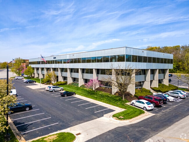
Property Record
9229 Ward Pky, Kansas City, MO 64114


Current Lease Availabilities
Property Detail
9229 Ward Pky
48-410-06-32-00-0-00-000
WARD PARKWAY OFFICE PARK BLK 6
Officebuilding
Jackson
R4O
Missouri
AE The base floodplain where base flood elevations are provided. AE Zones are now used on new format FIRMs instead of A1-A30 Zones.
3.36 AC
2024
Ward Parkway
2025
Kansas City
009900
Kansas City, MO-KS
64,468 SF
NEARBY LISTINGS FOR SALE OR LEASE
DEMOGRAPHICS near 9229 Ward Pky
1 mile
3 mile
5 mile
2025 Total Population
9,162
78,502
212,975
2030 Population
9,278
79,956
217,580
Pop Growth 2025-2030
+ 1.27%
+ 1.85%
+ 2.16%
Average Age
41
41
41
2025 Total Households
4,487
35,482
93,468
HH Growth 2025-2030
+ 1.23%
+ 1.75%
+ 2.24%
Median Household Inc
$84,261
$87,692
$87,662
Avg Household Size
2.00
2.10
2.20
2025 Avg HH Vehicles
2.00
2.00
2.00
Median Home Value
$261,869
$358,135
$355,943
Median Year Built
1958
1960
1962
Nearby Places
Map Layers
Map Styles
 Street
 Aerial
Layers
 Traffic
 Biking
Places
Listings with unknown addresses are not visible on the map
- Restaurants
- Banks
- Shops
- Fitness
- Groceries
PUBLIC TRANSPORTATION
COMMUTER RAIL
Kansas City (Lincoln Service Missouri River Runner - Amtrak, Missouri River Runner - Amtrak, Southwest Chief - Amtrak)
Drive
Walk
Distance
Kansas City (Lincoln Service Missouri River Runner - Amtrak, Missouri River Runner - Amtrak, Southwest Chief - Amtrak)
22 min
9.6 mi
AIRPORT
Kansas City International
Drive
Walk
Distance
Kansas City International
48 min
29.4 mi
Freight Ports
Tulsa Port Of Catoosa
Drive
Walk
Distance
Tulsa Port Of Catoosa
257 min
227.8 mi
Nearby Properties
Address
Land Use
TOTAL SIZE
Lot Size
Zoning
Address
Land Use
TOTAL SIZE
Lot Size
Zoning
47.39 AC
AG
Address
Land Use
TOTAL SIZE
Lot Size
Zoning
616,742 SF
13.59 AC
Address
Land Use
TOTAL SIZE
Lot Size
Zoning
195,691 SF
36.94 AC
R-1A
Address
Land Use
TOTAL SIZE
Lot Size
Zoning
188,248 SF
4.78 AC
C-2
Address
Land Use
TOTAL SIZE
Lot Size
Zoning
59,570 SF
8.46 AC
SD-O
Address
Land Use
TOTAL SIZE
Lot Size
Zoning
552,475 SF
Address
Land Use
TOTAL SIZE
Lot Size
Zoning
73,383 SF
9.53 AC
R-1
Address
Land Use
TOTAL SIZE
Lot Size
Zoning
465,394 SF
16.63 AC
Address
Land Use
TOTAL SIZE
Lot Size
Zoning
436,499 SF
22.71 AC
Address
Land Use
TOTAL SIZE
Lot Size
Zoning
73,793 SF
9.21 AC
R-1A
Address
Land Use
TOTAL SIZE
Lot Size
Zoning
69,958 SF
10.93 AC
R-1
Address
Land Use
TOTAL SIZE
Lot Size
Zoning
387,197 SF
Address
Land Use
TOTAL SIZE
Lot Size
Zoning
120,225 SF
9.13 AC
R-1
Address
Land Use
TOTAL SIZE
Lot Size
Zoning
457,500 SF
Address
Land Use
TOTAL SIZE
Lot Size
Zoning
157,280 SF
25.10 AC
Address
Land Use
TOTAL SIZE
Lot Size
Zoning
109,553 SF
3.08 AC
Address
Land Use
TOTAL SIZE
Lot Size
Zoning
67,981 SF
7.12 AC
R-1A
Address
Land Use
TOTAL SIZE
Lot Size
Zoning
40,931 SF
16.55 AC
R-1A
Address
Land Use
TOTAL SIZE
Lot Size
Zoning
405,226 SF
6.87 AC
MXD
Address
Land Use
TOTAL SIZE
Lot Size
Zoning
213,409 SF
5.20 AC
NXD
Address
Land Use
TOTAL SIZE
Lot Size
Zoning
85,287 SF
2.35 AC
R-1
Address
Land Use
TOTAL SIZE
Lot Size
Zoning
68,004 SF
7.75 AC
R-1B
Address
Land Use
TOTAL SIZE
Lot Size
Zoning
244,478 SF
26.69 AC
Address
Land Use
TOTAL SIZE
Lot Size
Zoning
262,727 SF
16.81 AC
C-2
Address
Land Use
TOTAL SIZE
Lot Size
Zoning
431,078 SF
Address
Land Use
TOTAL SIZE
Lot Size
Zoning
260,932 SF
4.77 AC
MXD
Address
Land Use
TOTAL SIZE
Lot Size
Zoning
65,128 SF
8.70 AC
Address
Land Use
TOTAL SIZE
Lot Size
Zoning
260,629 SF
7.17 AC
Address
Land Use
TOTAL SIZE
Lot Size
Zoning
202,498 SF
Address
Land Use
TOTAL SIZE
Lot Size
Zoning
315,160 SF
3.73 AC
The World's #1 Commercial Real Estate Marketplace
Connect with us
© 2026 CoStar Group
The information above has been obtained from sources believed reliable. While we do not doubt its accuracy we have not verified it and make no guarantee, warranty or representation about it. It is your responsibility to independently confirm its accuracy and completeness. Any projections, opinions, assumptions, or estimates used are for example only and do not represent the current or future performance of the property. The value of this transaction to you depends on tax and other factors which should be evaluated by your tax, financial, and legal advisors. You and your advisors should conduct a careful, independent investigation of the property to determine to your satisfaction the suitability of the property for your needs.