Property Record
9241 Wadsworth Blvd, Broomfield, CO 80021
NEARBY LISTINGS FOR SALE OR LEASE
Property Detail
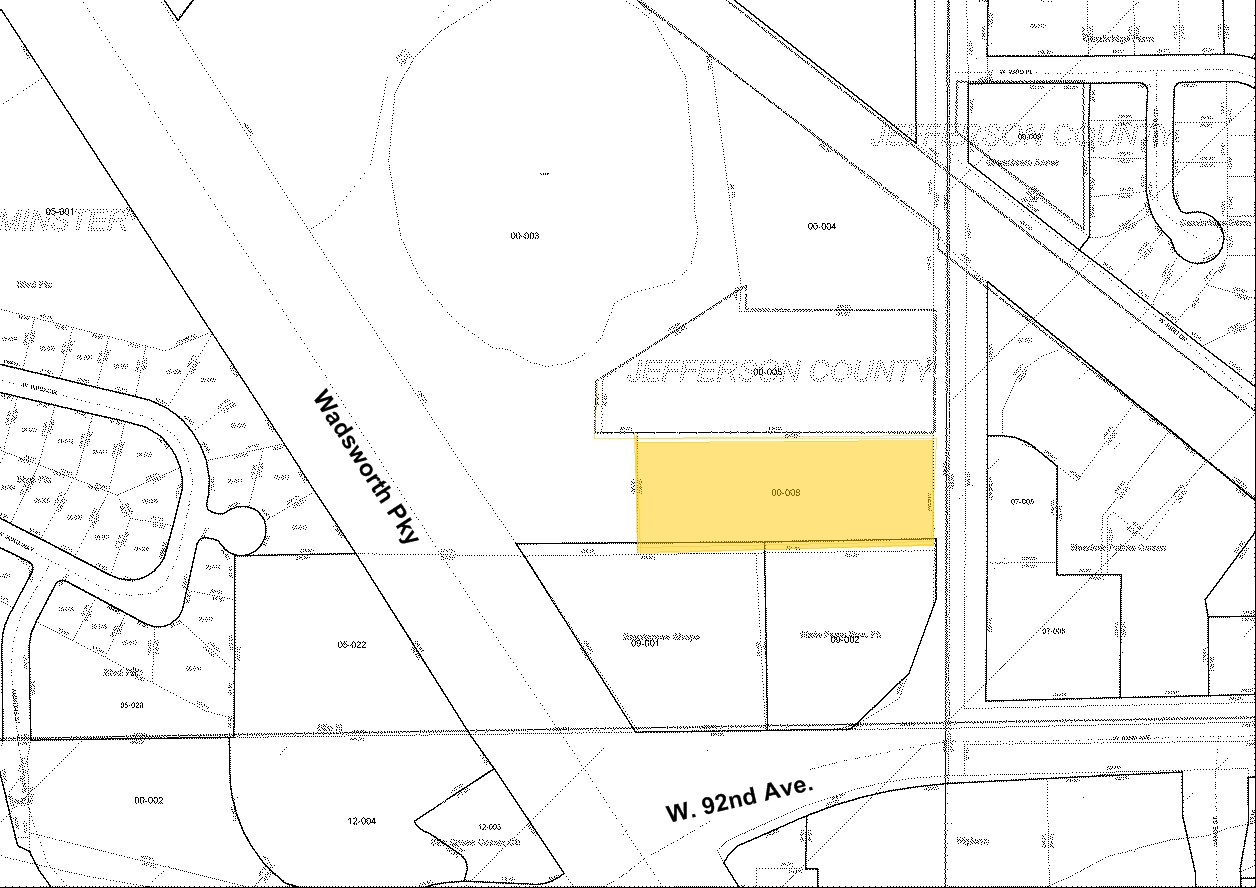
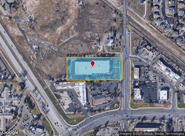
9241 Wadsworth Blvd
29-232-00-008
SECTION 23 TOWNSHIP 02 RANGE 69 QTR NW SIZE: 123418 VALUE: 2.833 KEY=059
Commercialnec
Jefferson
X
Colorado
08059C0202G
2.83 AC
2023
Northwest Denver
2024
Denver
009828
Denver-Aurora-Lakewood, CO
121,042 SF
DEMOGRAPHICS near 9241 Wadsworth Blvd
1 Mile
3 Mile
5 Mile
2024 Total Population
15,290
103,577
295,314
2029 Population
15,193
103,823
300,839
Pop Growth 2024-2029
(0.63%)
+ 0.24%
+ 1.87%
Average Age
40
40
40
2024 Total Households
6,618
41,386
115,840
HH Growth 2024-2029
(0.42%)
+ 0.30%
+ 1.91%
Median Household Inc
$81,406
$90,883
$83,299
Avg Household Size
2.20
2.40
2.50
2024 Avg HH Vehicles
2.00
2.00
2.00
Median Home Value
$425,889
$460,859
$454,600
Median Year Built
1984
1979
1979
Nearby Places
- Restaurants
- Banks
- Shops
- Fitness
- Groceries
PUBLIC TRANSPORTATION
COMMUTER RAIL
Westminster Station S-Bound (Union Station to Westminster Station - Regional Transportation District)
DRIVE
WALK
Distance
Westminster Station S-Bound (Union Station to Westminster Station - Regional Transportation District)
9 min
5.2 mi
Westminster Station N-Bound (Union Station to Westminster Station - Regional Transportation District)
DRIVE
WALK
Distance
Westminster Station N-Bound (Union Station to Westminster Station - Regional Transportation District)
11 min
5.6 mi
AIRPORT
Denver International
DRIVE
WALK
Distance
Denver International
39 min
29.7 mi
Freight Ports
Tulsa Port Of Catoosa
DRIVE
WALK
Distance
Tulsa Port Of Catoosa
736 min
715.2 mi
Nearby Properties
Address
Land Use
TOTAL SIZE
Lot Size
Zoning
Address
Land Use
TOTAL SIZE
Lot Size
Zoning
431,902 SF
17.63 AC
Address
Land Use
TOTAL SIZE
Lot Size
Zoning
211,191 SF
30.46 AC
Address
Land Use
TOTAL SIZE
Lot Size
Zoning
188,153 SF
9.78 AC
PUD
Address
Land Use
TOTAL SIZE
Lot Size
Zoning
209,009 SF
22.30 AC
Address
Land Use
TOTAL SIZE
Lot Size
Zoning
281,167 SF
19.52 AC
Address
Land Use
TOTAL SIZE
Lot Size
Zoning
674,481 SF
21.06 AC
Address
Land Use
TOTAL SIZE
Lot Size
Zoning
159,724 SF
8.11 AC
Address
Land Use
TOTAL SIZE
Lot Size
Zoning
53,602 SF
2.37 AC
Address
Land Use
TOTAL SIZE
Lot Size
Zoning
34,584 SF
13.70 AC
PUD
Address
Land Use
TOTAL SIZE
Lot Size
Zoning
250,701 SF
14.14 AC
Address
Land Use
TOTAL SIZE
Lot Size
Zoning
70,338 SF
2.57 AC
Address
Land Use
TOTAL SIZE
Lot Size
Zoning
121,639 SF
25.99 AC
Address
Land Use
TOTAL SIZE
Lot Size
Zoning
528,256 SF
3.87 AC
PUD
Address
Land Use
TOTAL SIZE
Lot Size
Zoning
114,230 SF
2.88 AC
Address
Land Use
TOTAL SIZE
Lot Size
Zoning
127,434 SF
7.53 AC
Address
Land Use
TOTAL SIZE
Lot Size
Zoning
133,573 SF
7.92 AC
PD
Address
Land Use
TOTAL SIZE
Lot Size
Zoning
133,573 SF
8.74 AC
PD
Address
Land Use
TOTAL SIZE
Lot Size
Zoning
310,000 SF
26.51 AC
Address
Land Use
TOTAL SIZE
Lot Size
Zoning
141,741 SF
5.58 AC
Address
Land Use
TOTAL SIZE
Lot Size
Zoning
315,637 SF
8.56 AC
Address
Land Use
TOTAL SIZE
Lot Size
Zoning
155,081 SF
7.42 AC
Address
Land Use
TOTAL SIZE
Lot Size
Zoning
307,396 SF
6.68 AC
PUD
Address
Land Use
TOTAL SIZE
Lot Size
Zoning
275,421 SF
7.79 AC
Address
Land Use
TOTAL SIZE
Lot Size
Zoning
559,786 SF
26.52 AC
Address
Land Use
TOTAL SIZE
Lot Size
Zoning
115,054 SF
21.38 AC
Address
Land Use
TOTAL SIZE
Lot Size
Zoning
293,594 SF
12.42 AC
I-2-PUD
Address
Land Use
TOTAL SIZE
Lot Size
Zoning
102,598 SF
7.52 AC
Address
Land Use
TOTAL SIZE
Lot Size
Zoning
269,040 SF
16.05 AC
Address
Land Use
TOTAL SIZE
Lot Size
Zoning
260,751 SF
8.01 AC
PUD
Address
Land Use
TOTAL SIZE
Lot Size
Zoning
99,957 SF
13.26 AC
The World's #1 Commercial Real Estate Marketplace
Connect with us
© 2025 CoStar Group
The information above has been obtained from sources believed reliable. While we do not doubt its accuracy we have not verified it and make no guarantee, warranty or representation about it. It is your responsibility to independently confirm its accuracy and completeness. Any projections, opinions, assumptions, or estimates used are for example only and do not represent the current or future performance of the property. The value of this transaction to you depends on tax and other factors which should be evaluated by your tax, financial, and legal advisors. You and your advisors should conduct a careful, independent investigation of the property to determine to your satisfaction the suitability of the property for your needs.