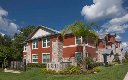
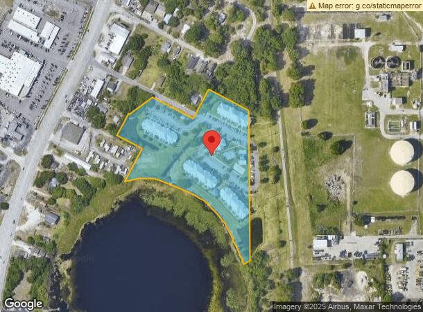
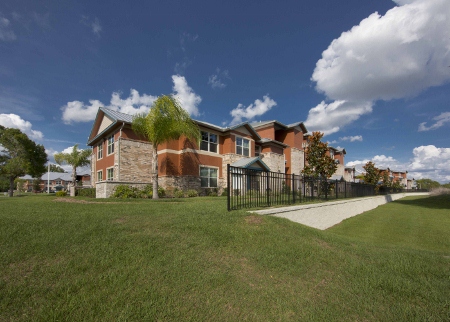
Property Record
930 5Th St, Winter Haven, FL 33881
NEARBY LISTINGS FOR SALE OR LEASE
Property Detail
930 5Th St
Lakeland-Winter Haven, FL
Lakeside Memorial Pk 2Nd Repla
26-28-17-000000-013010
NW1/4 OF NE1/4 BEG SE COR RUN N 738PT55 FT N 63 DEG 07 MIN W 239PT5 FT TO SE COR LOT 22 BLK D OF IDA LK SUB S 26 DEG 53 MIN W 165 FT N 63 DEG 07 MIN W 228 FT RUN S 47 DEG 29 MIN W 133.55 FT N 63 DEG 07 MIN W 25 FT S 26 DEG 53 MIN W 125 FT S 63 DEG 07
Governmentalpublicusegeneral
Polk
AE
Florida
12105C0365G
22
2023
6.71 AC
2023
Winter Haven/Lake Wales
013601
Tampa/St Petersburg
85,936 SF
DEMOGRAPHICS near 930 5Th St
1 Mile
3 Mile
5 Mile
2024 Total Population
6,543
49,497
109,894
2029 Population
7,972
59,690
132,662
Pop Growth 2024-2029
+ 21.84%
+ 20.59%
+ 20.72%
Average Age
42
41
41
2024 Total Households
2,749
19,806
43,083
HH Growth 2024-2029
+ 21.75%
+ 20.55%
+ 20.65%
Median Household Inc
$40,278
$44,831
$52,522
Avg Household Size
2.30
2.40
2.50
2024 Avg HH Vehicles
1.00
2.00
2.00
Median Home Value
$188,965
$174,087
$186,410
Median Year Built
1983
1976
1982
Nearby Places
- Restaurants
- Banks
- Shops
- Fitness
- Groceries
PUBLIC TRANSPORTATION
COMMUTER RAIL
Winter Haven (Silver Meteor - Amtrak, Silver Star - Amtrak)
DRIVE
WALK
Distance
Winter Haven (Silver Meteor - Amtrak, Silver Star - Amtrak)
8 min
3.9 mi
Freight Ports
Port of Tampa Bay
DRIVE
WALK
Distance
Port of Tampa Bay
70 min
48.9 mi
Nearby Properties
Address
Land Use
TOTAL SIZE
Lot Size
Zoning
Address
Land Use
TOTAL SIZE
Lot Size
Zoning
728,846 SF
28.07 AC
Address
Land Use
TOTAL SIZE
Lot Size
Zoning
250,170 SF
24.21 AC
Address
Land Use
TOTAL SIZE
Lot Size
Zoning
282,400 SF
19.59 AC
XX
Address
Land Use
TOTAL SIZE
Lot Size
Zoning
504,548 SF
26.82 AC
BR
Address
Land Use
TOTAL SIZE
Lot Size
Zoning
386,137 SF
39.91 AC
Address
Land Use
TOTAL SIZE
Lot Size
Zoning
267,076 SF
31.67 AC
Address
Land Use
TOTAL SIZE
Lot Size
Zoning
185,895 SF
16.16 AC
BR
Address
Land Use
TOTAL SIZE
Lot Size
Zoning
148,390 SF
10.42 AC
R1
Address
Land Use
TOTAL SIZE
Lot Size
Zoning
181,804 SF
52.32 AC
XX
Address
Land Use
TOTAL SIZE
Lot Size
Zoning
277,680 SF
43.76 AC
R1C
Address
Land Use
TOTAL SIZE
Lot Size
Zoning
102,307 SF
1.79 AC
RP
Address
Land Use
TOTAL SIZE
Lot Size
Zoning
77,388 SF
5.37 AC
BT
Address
Land Use
TOTAL SIZE
Lot Size
Zoning
90,230 SF
8.49 AC
Address
Land Use
TOTAL SIZE
Lot Size
Zoning
199,355 SF
15.71 AC
C4
Address
Land Use
TOTAL SIZE
Lot Size
Zoning
188,403 SF
27.79 AC
BT
Address
Land Use
TOTAL SIZE
Lot Size
Zoning
259,700 SF
51.96 AC
Address
Land Use
TOTAL SIZE
Lot Size
Zoning
135,885 SF
10.12 AC
Address
Land Use
TOTAL SIZE
Lot Size
Zoning
122,752 SF
1.68 AC
Address
Land Use
TOTAL SIZE
Lot Size
Zoning
277,729 SF
423.34 AC
Address
Land Use
TOTAL SIZE
Lot Size
Zoning
173,328 SF
37.45 AC
C3
Address
Land Use
TOTAL SIZE
Lot Size
Zoning
97,912 SF
7.76 AC
ILS
Address
Land Use
TOTAL SIZE
Lot Size
Zoning
90,200 SF
1.93 AC
RP
Address
Land Use
TOTAL SIZE
Lot Size
Zoning
76,664 SF
18.64 AC
RP
Address
Land Use
TOTAL SIZE
Lot Size
Zoning
106,524 SF
11.32 AC
Address
Land Use
TOTAL SIZE
Lot Size
Zoning
172,254 SF
1.81 AC
BR
Address
Land Use
TOTAL SIZE
Lot Size
Zoning
77,824 SF
12.78 AC
Address
Land Use
TOTAL SIZE
Lot Size
Zoning
169,925 SF
11.88 AC
C3
Address
Land Use
TOTAL SIZE
Lot Size
Zoning
40,781 SF
6.48 AC
RP
Address
Land Use
TOTAL SIZE
Lot Size
Zoning
138,854 SF
13.39 AC
Address
Land Use
TOTAL SIZE
Lot Size
Zoning
36,864 SF
1.46 AC
RP
The World's #1 Commercial Real Estate Marketplace
Connect with us
© 2025 CoStar Group
The information above has been obtained from sources believed reliable. While we do not doubt its accuracy we have not verified it and make no guarantee, warranty or representation about it. It is your responsibility to independently confirm its accuracy and completeness. Any projections, opinions, assumptions, or estimates used are for example only and do not represent the current or future performance of the property. The value of this transaction to you depends on tax and other factors which should be evaluated by your tax, financial, and legal advisors. You and your advisors should conduct a careful, independent investigation of the property to determine to your satisfaction the suitability of the property for your needs.