Property Record
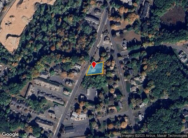
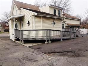
937 S Main St, Plantsville, CT 06479

NEARBY LISTINGS FOR SALE OR LEASE
Property Detail
937 S Main St
SOUT-000063-000000-000114
Hartford
Commercialofficeresidentialmixeduse
Connecticut
X
114
09003C0584G
0.32 AC
2025
Southington
2025
Hartford
430400
Hartford-West Hartford-East Hartford, CT
2,542 SF
DEMOGRAPHICS near 937 S Main St
1 Mile
3 Mile
5 Mile
2024 Total Population
6,286
36,756
78,436
2029 Population
6,225
36,606
78,095
Pop Growth 2024-2029
(0.97%)
(0.41%)
(0.43%)
Average Age
43
43
43
2024 Total Households
2,578
14,285
30,199
HH Growth 2024-2029
(1.09%)
(0.48%)
(0.50%)
Median Household Inc
$81,969
$105,538
$105,037
Avg Household Size
2.30
2.50
2.50
2024 Avg HH Vehicles
2.00
2.00
2.00
Median Home Value
$272,662
$310,779
$314,685
Median Year Built
1964
1971
1971
Nearby Places
Map Layers
Map Styles
 Street
 Aerial
- Restaurants
- Banks
- Shops
- Fitness
- Groceries
PUBLIC TRANSPORTATION
COMMUTER RAIL
DRIVE
WALK
Distance
10 min
7.4 mi
DRIVE
WALK
Distance
11 min
7.5 mi
AIRPORT
Tweed/New Haven
DRIVE
WALK
Distance
Tweed/New Haven
37 min
24.8 mi
Bradley International
DRIVE
WALK
Distance
Bradley International
58 min
34.0 mi
SALE & LEASE HISTORY
LISTING DATE
SALE/LEASE

Dec 04, 2020
For Sale
Nearby Properties
Address
Land Use
TOTAL SIZE
Lot Size
Zoning
Address
Land Use
TOTAL SIZE
Lot Size
Zoning
395,492 SF
54.09 AC
R-20/2
Address
Land Use
TOTAL SIZE
Lot Size
Zoning
531,397 SF
82.40 AC
I-2
Address
Land Use
TOTAL SIZE
Lot Size
Zoning
243,820 SF
39.42 AC
I-2
Address
Land Use
TOTAL SIZE
Lot Size
Zoning
73,961 SF
27.36 AC
I-2
Address
Land Use
TOTAL SIZE
Lot Size
Zoning
106,970 SF
7.92 AC
R-12
Address
Land Use
TOTAL SIZE
Lot Size
Zoning
86,019 SF
7.51 AC
B
Address
Land Use
TOTAL SIZE
Lot Size
Zoning
128,599 SF
14.75 AC
R-20/2
Address
Land Use
TOTAL SIZE
Lot Size
Zoning
130,912 SF
11 AC
R-12
Address
Land Use
TOTAL SIZE
Lot Size
Zoning
14,307 SF
13.39 AC
R-20/2
Address
Land Use
TOTAL SIZE
Lot Size
Zoning
281,623 SF
39.24 AC
I-2
Address
Land Use
TOTAL SIZE
Lot Size
Zoning
130,252 SF
14.82 AC
B
Address
Land Use
TOTAL SIZE
Lot Size
Zoning
137,510 SF
12.95 AC
B
Address
Land Use
TOTAL SIZE
Lot Size
Zoning
172,891 SF
75 AC
I-2
Address
Land Use
TOTAL SIZE
Lot Size
Zoning
241,500 SF
16.93 AC
I-1
Address
Land Use
TOTAL SIZE
Lot Size
Zoning
150,972 SF
9.99 AC
I-1
Address
Land Use
TOTAL SIZE
Lot Size
Zoning
98,463 SF
5.01 AC
I-1
Address
Land Use
TOTAL SIZE
Lot Size
Zoning
154,702 SF
33.86 AC
I-2
Address
Land Use
TOTAL SIZE
Lot Size
Zoning
121,648 SF
6.96 AC
I-1
Address
Land Use
TOTAL SIZE
Lot Size
Zoning
134,876 SF
19.44 AC
R-12
Address
Land Use
TOTAL SIZE
Lot Size
Zoning
12.28 AC
R-20/2
Address
Land Use
TOTAL SIZE
Lot Size
Zoning
14,200 SF
19.20 AC
I-2
Address
Land Use
TOTAL SIZE
Lot Size
Zoning
9.07 AC
B
Address
Land Use
TOTAL SIZE
Lot Size
Zoning
101,250 SF
16.91 AC
B
Address
Land Use
TOTAL SIZE
Lot Size
Zoning
67,503 SF
2.53 AC
B
Address
Land Use
TOTAL SIZE
Lot Size
Zoning
68,669 SF
5.35 AC
B
Address
Land Use
TOTAL SIZE
Lot Size
Zoning
76,113 SF
18.68 AC
R-20/2
Address
Land Use
TOTAL SIZE
Lot Size
Zoning
22,512 SF
3.31 AC
CB
Address
Land Use
TOTAL SIZE
Lot Size
Zoning
32,076 SF
16.33 AC
R-20/2
Address
Land Use
TOTAL SIZE
Lot Size
Zoning
57,572 SF
9.87 AC
I-1
Address
Land Use
TOTAL SIZE
Lot Size
Zoning
143,115 SF
13.14 AC
I-2
The World's #1 Commercial Real Estate Marketplace
Connect with us
© 2025 CoStar Group
The information above has been obtained from sources believed reliable. While we do not doubt its accuracy we have not verified it and make no guarantee, warranty or representation about it. It is your responsibility to independently confirm its accuracy and completeness. Any projections, opinions, assumptions, or estimates used are for example only and do not represent the current or future performance of the property. The value of this transaction to you depends on tax and other factors which should be evaluated by your tax, financial, and legal advisors. You and your advisors should conduct a careful, independent investigation of the property to determine to your satisfaction the suitability of the property for your needs.