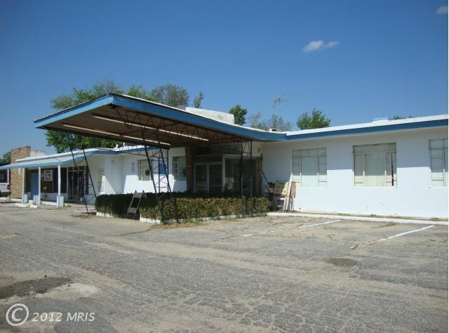
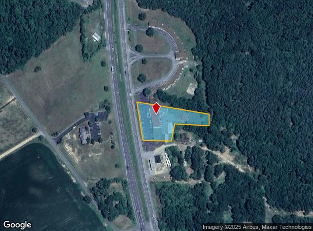
Property Record
9370 Crain Hwy, Bel Alton, MD 20611
NEARBY LISTINGS FOR SALE OR LEASE
-
-
View all Bel Alton listings for sale on LoopNet.com
Property Detail
9370 Crain Hwy
04-007972
Town Of La Plata
Bartavern
1.3677 AC ON E SI RT 301
X
Charles
24017C0330C
Maryland
2024
1.36 AC
2024
Charles County
851100
Washington, DC
9,863 SF
Washington-Arlington-Alexandria, DC-VA-MD-WV
DEMOGRAPHICS near 9370 Crain Hwy
1 Mile
3 Mile
5 Mile
2024 Total Population
503
1,917
10,925
2029 Population
512
1,959
11,380
Pop Growth 2024-2029
+ 1.79%
+ 2.19%
+ 4.16%
Average Age
43
43
41
2024 Total Households
182
689
3,931
HH Growth 2024-2029
+ 1.65%
+ 2.18%
+ 4.17%
Median Household Inc
$128,125
$131,312
$120,379
Avg Household Size
2.70
2.70
2.70
2024 Avg HH Vehicles
3.00
3.00
2.00
Median Home Value
$455,714
$471,296
$430,429
Median Year Built
1975
1976
1986
Nearby Places
- Restaurants
- Banks
- Shops
- Fitness
- Groceries
PUBLIC TRANSPORTATION
AIRPORT
Ronald Reagan Washington Ntl
DRIVE
WALK
Distance
Ronald Reagan Washington Ntl
65 min
40.8 mi
Freight Ports
Port of Baltimore
DRIVE
WALK
Distance
Port of Baltimore
100 min
67.6 mi
Nearby Properties
Address
Land Use
TOTAL SIZE
Lot Size
Zoning
Address
Land Use
TOTAL SIZE
Lot Size
Zoning
1,350 SF
820.92 AC
RC
Address
Land Use
TOTAL SIZE
Lot Size
Zoning
35,571 SF
100 AC
AC
Address
Land Use
TOTAL SIZE
Lot Size
Zoning
38,040 SF
12.76 AC
CV
Address
Land Use
TOTAL SIZE
Lot Size
Zoning
19,638 SF
4.84 AC
CV
Address
Land Use
TOTAL SIZE
Lot Size
Zoning
10.32 AC
RC
Address
Land Use
TOTAL SIZE
Lot Size
Zoning
30 AC
RC
Address
Land Use
TOTAL SIZE
Lot Size
Zoning
9,442 SF
28.36 AC
AC
Address
Land Use
TOTAL SIZE
Lot Size
Zoning
10,237 SF
25.52 AC
AC
Address
Land Use
TOTAL SIZE
Lot Size
Zoning
7,200 SF
3.88 AC
AC
Address
Land Use
TOTAL SIZE
Lot Size
Zoning
14,748 SF
9.40 AC
CV
Address
Land Use
TOTAL SIZE
Lot Size
Zoning
8,568 SF
6.80 AC
CV
Address
Land Use
TOTAL SIZE
Lot Size
Zoning
5,840 SF
0.84 AC
CV
Address
Land Use
TOTAL SIZE
Lot Size
Zoning
7,150 SF
2.84 AC
CV
Address
Land Use
TOTAL SIZE
Lot Size
Zoning
8,328 SF
2.08 AC
CV/AC
Address
Land Use
TOTAL SIZE
Lot Size
Zoning
35,244 SF
6.10 AC
RC
Address
Land Use
TOTAL SIZE
Lot Size
Zoning
11,042 SF
8.55 AC
RV
Address
Land Use
TOTAL SIZE
Lot Size
Zoning
4,716 SF
1.25 AC
CV
Address
Land Use
TOTAL SIZE
Lot Size
Zoning
4,628 SF
11.56 AC
AC
Address
Land Use
TOTAL SIZE
Lot Size
Zoning
3,968 SF
0.96 AC
CV
Address
Land Use
TOTAL SIZE
Lot Size
Zoning
4,427 SF
2.56 AC
RC
Address
Land Use
TOTAL SIZE
Lot Size
Zoning
20.20 AC
CV
Address
Land Use
TOTAL SIZE
Lot Size
Zoning
3,152 SF
4.26 AC
CC
Address
Land Use
TOTAL SIZE
Lot Size
Zoning
2,452 SF
2.68 AC
IG
Address
Land Use
TOTAL SIZE
Lot Size
Zoning
5,600 SF
0.92 AC
CV
Address
Land Use
TOTAL SIZE
Lot Size
Zoning
3,497 SF
1.46 AC
AC
Address
Land Use
TOTAL SIZE
Lot Size
Zoning
4,851 SF
1.11 AC
RC
Address
Land Use
TOTAL SIZE
Lot Size
Zoning
4,318 SF
2.02 AC
RC
Address
Land Use
TOTAL SIZE
Lot Size
Zoning
3,114 SF
6.69 AC
AC
Address
Land Use
TOTAL SIZE
Lot Size
Zoning
3,906 SF
1.39 AC
RC
The World's #1 Commercial Real Estate Marketplace
Connect with us
© 2025 CoStar Group
The information above has been obtained from sources believed reliable. While we do not doubt its accuracy we have not verified it and make no guarantee, warranty or representation about it. It is your responsibility to independently confirm its accuracy and completeness. Any projections, opinions, assumptions, or estimates used are for example only and do not represent the current or future performance of the property. The value of this transaction to you depends on tax and other factors which should be evaluated by your tax, financial, and legal advisors. You and your advisors should conduct a careful, independent investigation of the property to determine to your satisfaction the suitability of the property for your needs.