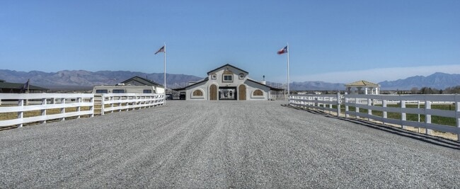
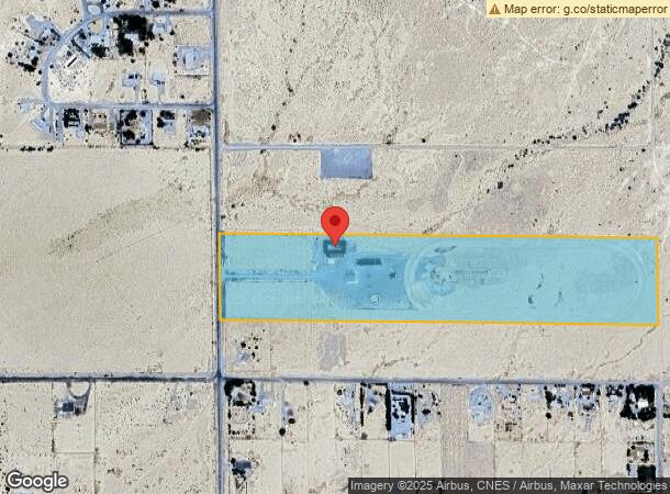
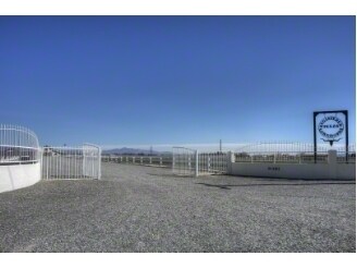
Property Record
9381 Homestead Rd, Pahrump, NV 89061

NEARBY LISTINGS FOR SALE OR LEASE
-
-
View all Pahrump listings for sale on LoopNet.com
Property Detail
9381 Homestead Rd
Pahrump, NV
Nye
45-411-03
Nevada
Sfr
30 AC
X
Carson City/Nevada Area
32023C8905G
Other Market Areas
4,896 SF
DEMOGRAPHICS near 9381 Homestead Rd
1 Mile
3 Mile
5 Mile
2024 Total Population
220
3,494
11,506
2029 Population
255
4,081
13,579
Pop Growth 2024-2029
+ 15.91%
+ 16.80%
+ 18.02%
Average Age
48
47
49
2024 Total Households
89
1,405
4,813
HH Growth 2024-2029
+ 16.85%
+ 16.80%
+ 18.08%
Median Household Inc
$58,636
$57,680
$64,671
Avg Household Size
2.30
2.30
2.30
2024 Avg HH Vehicles
2.00
2.00
2.00
Median Home Value
$233,928
$230,172
$279,386
Median Year Built
1993
1994
1998
Nearby Places
Map Layers
Map Styles
 Street
 Aerial
- Restaurants
- Banks
- Shops
- Fitness
- Groceries
SALE & LEASE HISTORY
LISTING DATE
SALE/LEASE

Oct 17, 2024
For Sale
Mar 28, 2018
For Sale
Jun 19, 2024
For Sale
Nearby Properties
Address
Land Use
TOTAL SIZE
Lot Size
Zoning
Address
Land Use
TOTAL SIZE
Lot Size
Zoning
2,385.88 AC
R
Address
Land Use
TOTAL SIZE
Lot Size
Zoning
1,372.49 AC
R
Address
Land Use
TOTAL SIZE
Lot Size
Zoning
1,784.91 AC
R
Address
Land Use
TOTAL SIZE
Lot Size
Zoning
648 AC
R
Address
Land Use
TOTAL SIZE
Lot Size
Zoning
0.46 AC
VR-8
Address
Land Use
TOTAL SIZE
Lot Size
Zoning
18,650 SF
20 AC
BR
Address
Land Use
TOTAL SIZE
Lot Size
Zoning
400 AC
R
Address
Land Use
TOTAL SIZE
Lot Size
Zoning
275 AC
R
Address
Land Use
TOTAL SIZE
Lot Size
Zoning
286.91 AC
SPLIT
Address
Land Use
TOTAL SIZE
Lot Size
Zoning
4,671 SF
20.68 AC
BR
Address
Land Use
TOTAL SIZE
Lot Size
Zoning
156.91 AC
R
Address
Land Use
TOTAL SIZE
Lot Size
Zoning
450.44 AC
R
Address
Land Use
TOTAL SIZE
Lot Size
Zoning
24,192 SF
8.09 AC
BO
Address
Land Use
TOTAL SIZE
Lot Size
Zoning
202.52 AC
R
Address
Land Use
TOTAL SIZE
Lot Size
Zoning
7,135 SF
2.20 AC
RE-2
Address
Land Use
TOTAL SIZE
Lot Size
Zoning
37.20 AC
CF
Address
Land Use
TOTAL SIZE
Lot Size
Zoning
5,563 SF
4.32 AC
RH-4.5
Address
Land Use
TOTAL SIZE
Lot Size
Zoning
3,040 SF
37.12 AC
CF
Address
Land Use
TOTAL SIZE
Lot Size
Zoning
21.98 AC
GC
Address
Land Use
TOTAL SIZE
Lot Size
Zoning
39.19 AC
GC
Address
Land Use
TOTAL SIZE
Lot Size
Zoning
2,800 SF
5.65 AC
GC
Address
Land Use
TOTAL SIZE
Lot Size
Zoning
115.53 AC
VR-8
Address
Land Use
TOTAL SIZE
Lot Size
Zoning
7,852 SF
2.03 AC
NC
Address
Land Use
TOTAL SIZE
Lot Size
Zoning
2,032 SF
1.10 AC
RE-1
Address
Land Use
TOTAL SIZE
Lot Size
Zoning
3,049 SF
1.10 AC
RE-1
Address
Land Use
TOTAL SIZE
Lot Size
Zoning
4,554 SF
1.10 AC
RE-1
Address
Land Use
TOTAL SIZE
Lot Size
Zoning
2,000 SF
1.10 AC
NC
Address
Land Use
TOTAL SIZE
Lot Size
Zoning
1,593 SF
1.40 AC
RE-1
Address
Land Use
TOTAL SIZE
Lot Size
Zoning
4,680 SF
13.82 AC
BO
Address
Land Use
TOTAL SIZE
Lot Size
Zoning
1,540 SF
1.10 AC
NC
The World's #1 Commercial Real Estate Marketplace
Connect with us
© 2025 CoStar Group
The information above has been obtained from sources believed reliable. While we do not doubt its accuracy we have not verified it and make no guarantee, warranty or representation about it. It is your responsibility to independently confirm its accuracy and completeness. Any projections, opinions, assumptions, or estimates used are for example only and do not represent the current or future performance of the property. The value of this transaction to you depends on tax and other factors which should be evaluated by your tax, financial, and legal advisors. You and your advisors should conduct a careful, independent investigation of the property to determine to your satisfaction the suitability of the property for your needs.