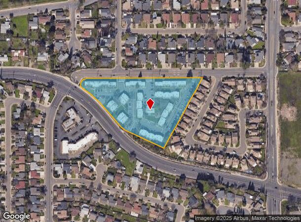
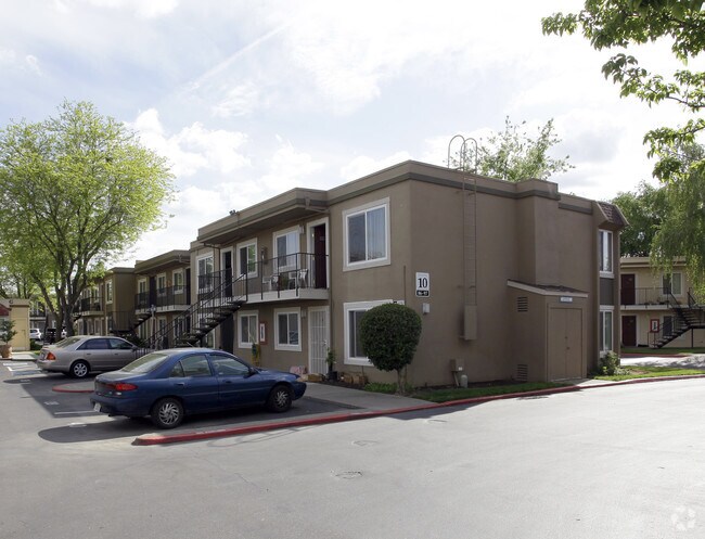
Property Record
9400 N Kiefer Blvd, Sacramento, CA 95826

NEARBY LISTINGS FOR SALE OR LEASE
-
-
View all Sacramento listings for sale on LoopNet.com
Property Detail
9400 N Kiefer Blvd
074-0370-054
POR OF S 1/2 OF SEC 17, T8N, R6E, MDB&M DESC AS:BEG AT A PT LOC S 89D12' W 426.85 FT AND S 28D05'02 W533.99 FT FM THE NE COR OF THE SW 1/4 OF SD SEC 17; TH FM SD POB N 65D26'21 W269.51 FT; TH N49D15'57 W42.99FT TH N39D36'32 W119.16FT; TH AL
Apartment
Sacramento
X
California
06067C0215H
4.18 AC
2024
Rosemont
2025
Sacramento
009108
Sacramento--Roseville--Arden-Arcade, CA
80,296 SF
DEMOGRAPHICS near 9400 N Kiefer Blvd
1 Mile
3 Mile
5 Mile
2024 Total Population
15,901
65,209
236,150
2029 Population
16,020
65,535
237,930
Pop Growth 2024-2029
+ 0.75%
+ 0.50%
+ 0.75%
Average Age
39
40
39
2024 Total Households
5,965
24,881
89,590
HH Growth 2024-2029
+ 0.80%
+ 0.49%
+ 0.78%
Median Household Inc
$86,263
$84,578
$74,317
Avg Household Size
2.60
2.60
2.50
2024 Avg HH Vehicles
2.00
2.00
2.00
Median Home Value
$397,860
$420,968
$445,481
Median Year Built
1976
1973
1973
Nearby Places
Map Layers
Map Styles
 Street
 Aerial
- Restaurants
- Banks
- Shops
- Fitness
- Groceries
PUBLIC TRANSPORTATION
AIRPORT
Sacramento International
DRIVE
WALK
Distance
Sacramento International
33 min
21.8 mi
Nearby Properties
Address
Land Use
TOTAL SIZE
Lot Size
Zoning
Address
Land Use
TOTAL SIZE
Lot Size
Zoning
7,742 SF
12.66 AC
M-1S-SWR
Address
Land Use
TOTAL SIZE
Lot Size
Zoning
149,566 SF
9.68 AC
M-2S
Address
Land Use
TOTAL SIZE
Lot Size
Zoning
266,841 SF
47.29 AC
RD-5
Address
Land Use
TOTAL SIZE
Lot Size
Zoning
119,380 SF
18.92 AC
M-2S
Address
Land Use
TOTAL SIZE
Lot Size
Zoning
584,820 SF
29.12 AC
M-2S
Address
Land Use
TOTAL SIZE
Lot Size
Zoning
181,573 SF
12.10 AC
SPA (MFSPA
Address
Land Use
TOTAL SIZE
Lot Size
Zoning
345,600 SF
14.84 AC
M-1S-SWR
Address
Land Use
TOTAL SIZE
Lot Size
Zoning
137,520 SF
10.37 AC
BP (PC)(PD
Address
Land Use
TOTAL SIZE
Lot Size
Zoning
387,136 SF
8.85 AC
RD-30
Address
Land Use
TOTAL SIZE
Lot Size
Zoning
168,846 SF
7.58 AC
RD-30 (PC)
Address
Land Use
TOTAL SIZE
Lot Size
Zoning
139,500 SF
5.21 AC
MP
Address
Land Use
TOTAL SIZE
Lot Size
Zoning
119,824 SF
7.64 AC
RD-30 (PC)
Address
Land Use
TOTAL SIZE
Lot Size
Zoning
0.21 AC
RD-5
Address
Land Use
TOTAL SIZE
Lot Size
Zoning
135,375 SF
7.40 AC
RD-30
Address
Land Use
TOTAL SIZE
Lot Size
Zoning
221,337 SF
12.19 AC
RD 25
Address
Land Use
TOTAL SIZE
Lot Size
Zoning
198,131 SF
13.36 AC
BP
Address
Land Use
TOTAL SIZE
Lot Size
Zoning
169,618 SF
10.44 AC
RD-4
Address
Land Use
TOTAL SIZE
Lot Size
Zoning
188,144 SF
16.90 AC
M-2S
Address
Land Use
TOTAL SIZE
Lot Size
Zoning
Address
Land Use
TOTAL SIZE
Lot Size
Zoning
133,620 SF
11.71 AC
C-2-SPD
Address
Land Use
TOTAL SIZE
Lot Size
Zoning
143,004 SF
8.81 AC
M-2S
Address
Land Use
TOTAL SIZE
Lot Size
Zoning
12.04 AC
M-1S-R
Address
Land Use
TOTAL SIZE
Lot Size
Zoning
8,724 SF
101.84 AC
M-2 (SM)
Address
Land Use
TOTAL SIZE
Lot Size
Zoning
387,136 SF
10.21 AC
RD-30
Address
Land Use
TOTAL SIZE
Lot Size
Zoning
110,960 SF
6.62 AC
SPA (MFSPA
Address
Land Use
TOTAL SIZE
Lot Size
Zoning
184,249 SF
10.72 AC
OIMU (FBSP
Address
Land Use
TOTAL SIZE
Lot Size
Zoning
128,972 SF
7.32 AC
R-3
Address
Land Use
TOTAL SIZE
Lot Size
Zoning
100,000 SF
7.03 AC
SPA (MFSPA
Address
Land Use
TOTAL SIZE
Lot Size
Zoning
203,374 SF
12 AC
RD-20
Address
Land Use
TOTAL SIZE
Lot Size
Zoning
85,131 SF
4.90 AC
RD 20
The World's #1 Commercial Real Estate Marketplace
Connect with us
© 2026 CoStar Group
The information above has been obtained from sources believed reliable. While we do not doubt its accuracy we have not verified it and make no guarantee, warranty or representation about it. It is your responsibility to independently confirm its accuracy and completeness. Any projections, opinions, assumptions, or estimates used are for example only and do not represent the current or future performance of the property. The value of this transaction to you depends on tax and other factors which should be evaluated by your tax, financial, and legal advisors. You and your advisors should conduct a careful, independent investigation of the property to determine to your satisfaction the suitability of the property for your needs.