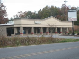
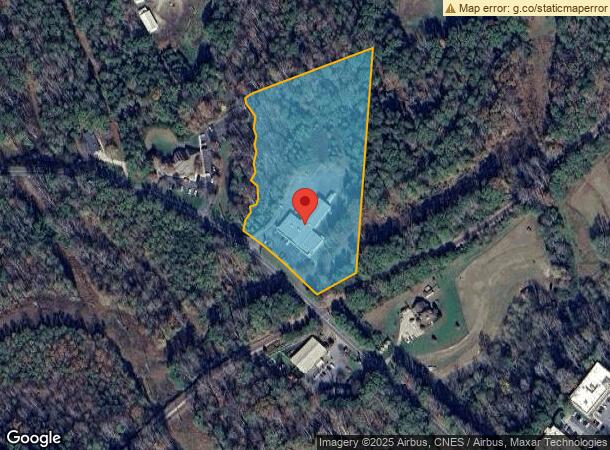
Property Record
941 Wyke Rd, Shelby, NC 28150
NEARBY LISTINGS FOR SALE OR LEASE
Property Detail
941 Wyke Rd
51985
5.313ACPB20-105R&MDEVPROP
Miscellaneous
Cleveland
X
North Carolina
3710254700J
69
2024
5.31 AC
2024
Cleveland County
950900
Charlotte
11,480 SF
Shelby, NC
DEMOGRAPHICS near 941 Wyke Rd
1 Mile
3 Mile
5 Mile
2024 Total Population
4,417
22,238
36,561
2029 Population
4,634
23,352
38,242
Pop Growth 2024-2029
+ 4.91%
+ 5.01%
+ 4.60%
Average Age
42
42
42
2024 Total Households
1,944
9,363
15,248
HH Growth 2024-2029
+ 4.89%
+ 5.01%
+ 4.61%
Median Household Inc
$37,957
$38,870
$43,894
Avg Household Size
2.20
2.20
2.30
2024 Avg HH Vehicles
2.00
2.00
2.00
Median Home Value
$125,487
$143,919
$148,353
Median Year Built
1970
1973
1976
Nearby Places
- Restaurants
- Banks
- Shops
- Fitness
- Groceries
SALE & LEASE HISTORY
LISTING DATE
SALE/LEASE

Sep 25, 2016
For Lease
Sep 23, 2016
For Sale
Nearby Properties
Address
Land Use
TOTAL SIZE
Lot Size
Zoning
Address
Land Use
TOTAL SIZE
Lot Size
Zoning
420 SF
235.30 AC
HI
Address
Land Use
TOTAL SIZE
Lot Size
Zoning
15.70 AC
RO
Address
Land Use
TOTAL SIZE
Lot Size
Zoning
92,278 SF
41.38 AC
R10
Address
Land Use
TOTAL SIZE
Lot Size
Zoning
12.80 AC
R10
Address
Land Use
TOTAL SIZE
Lot Size
Zoning
6,250 SF
18.80 AC
HI
Address
Land Use
TOTAL SIZE
Lot Size
Zoning
106,794 SF
40.60 AC
HI
Address
Land Use
TOTAL SIZE
Lot Size
Zoning
9.55 AC
RO
Address
Land Use
TOTAL SIZE
Lot Size
Zoning
18,864 SF
10.65 AC
ROCU
Address
Land Use
TOTAL SIZE
Lot Size
Zoning
8,712 SF
13.95 AC
R6
Address
Land Use
TOTAL SIZE
Lot Size
Zoning
20.38 AC
RO
Address
Land Use
TOTAL SIZE
Lot Size
Zoning
1,436 SF
8.02 AC
RO
Address
Land Use
TOTAL SIZE
Lot Size
Zoning
62.33 AC
R8
Address
Land Use
TOTAL SIZE
Lot Size
Zoning
224,162 SF
29.82 AC
GBCU
Address
Land Use
TOTAL SIZE
Lot Size
Zoning
24,652 SF
3.72 AC
R10
Address
Land Use
TOTAL SIZE
Lot Size
Zoning
71,644 SF
7.67 AC
GB
Address
Land Use
TOTAL SIZE
Lot Size
Zoning
63,543 SF
24.07 AC
R20
Address
Land Use
TOTAL SIZE
Lot Size
Zoning
78,165 SF
7.41 AC
GB
Address
Land Use
TOTAL SIZE
Lot Size
Zoning
21,040 SF
22.83 AC
GB
Address
Land Use
TOTAL SIZE
Lot Size
Zoning
24,255 SF
8.28 AC
GB2
Address
Land Use
TOTAL SIZE
Lot Size
Zoning
44,684 SF
4.44 AC
RO
Address
Land Use
TOTAL SIZE
Lot Size
Zoning
130 SF
5.84 AC
CB
Address
Land Use
TOTAL SIZE
Lot Size
Zoning
46,948 SF
0.02 AC
GB
Address
Land Use
TOTAL SIZE
Lot Size
Zoning
134,978 SF
17.23 AC
GB2CU
Address
Land Use
TOTAL SIZE
Lot Size
Zoning
50,771 SF
2.40 AC
GB
Address
Land Use
TOTAL SIZE
Lot Size
Zoning
43,540 SF
2.96 AC
GI
Address
Land Use
TOTAL SIZE
Lot Size
Zoning
29,969 SF
9.28 AC
CPD
Address
Land Use
TOTAL SIZE
Lot Size
Zoning
19,069 SF
12.69 AC
ROCU
Address
Land Use
TOTAL SIZE
Lot Size
Zoning
36,511 SF
11.16 AC
GB2
Address
Land Use
TOTAL SIZE
Lot Size
Zoning
49,947 SF
1 AC
GB
Address
Land Use
TOTAL SIZE
Lot Size
Zoning
2,585 SF
5.62 AC
RO
The World's #1 Commercial Real Estate Marketplace
Connect with us
© 2025 CoStar Group
The information above has been obtained from sources believed reliable. While we do not doubt its accuracy we have not verified it and make no guarantee, warranty or representation about it. It is your responsibility to independently confirm its accuracy and completeness. Any projections, opinions, assumptions, or estimates used are for example only and do not represent the current or future performance of the property. The value of this transaction to you depends on tax and other factors which should be evaluated by your tax, financial, and legal advisors. You and your advisors should conduct a careful, independent investigation of the property to determine to your satisfaction the suitability of the property for your needs.