Property Record
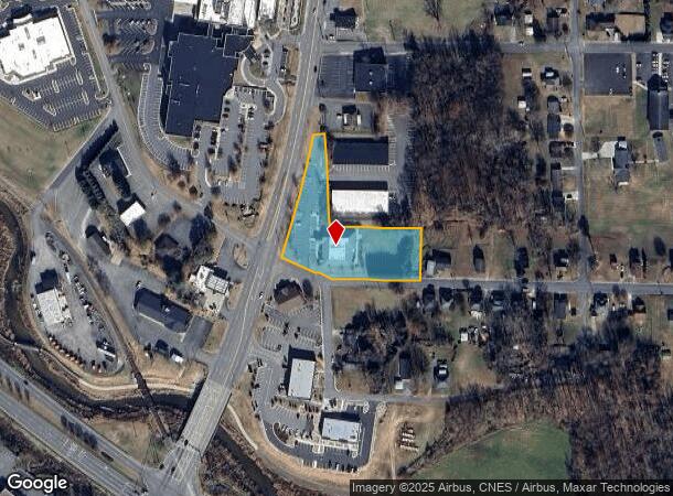
951 Rockford St, Mount Airy, NC 27030


NEARBY LISTINGS FOR SALE OR LEASE
Property Detail
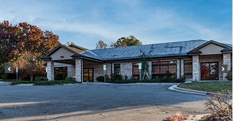
951 Rockford St
5929-07-69-3875
Hospital Area
Medicalbuilding
PB 41 PG 92
X
Surry
3710592900J
North Carolina
0
1.65 AC
2024
Hickory/Morganton
930400
Other Market Areas
8,516 SF
Mount Airy, NC
DEMOGRAPHICS near 951 Rockford St
1 Mile
3 Mile
5 Mile
2024 Total Population
4,294
16,524
28,706
2029 Population
4,373
16,748
28,918
Pop Growth 2024-2029
+ 1.84%
+ 1.36%
+ 0.74%
Average Age
42
44
43
2024 Total Households
1,930
7,349
12,372
HH Growth 2024-2029
+ 1.87%
+ 1.37%
+ 0.75%
Median Household Inc
$34,034
$45,523
$47,236
Avg Household Size
2.10
2.20
2.20
2024 Avg HH Vehicles
1.00
2.00
2.00
Median Home Value
$146,893
$151,718
$152,048
Median Year Built
1966
1971
1975
Nearby Places
- Restaurants
- Banks
- Shops
- Fitness
- Groceries
SALE & LEASE HISTORY
LISTING DATE
SALE/LEASE

Nov 11, 2021
For Lease
Nov 11, 2021
For Sale
Nearby Properties
Address
Land Use
TOTAL SIZE
Lot Size
Zoning
Address
Land Use
TOTAL SIZE
Lot Size
Zoning
240,171 SF
12 AC
B5
Address
Land Use
TOTAL SIZE
Lot Size
Zoning
200,663 SF
10.49 AC
R8
Address
Land Use
TOTAL SIZE
Lot Size
Zoning
86,738 SF
29.56 AC
R6
Address
Land Use
TOTAL SIZE
Lot Size
Zoning
93,565 SF
23.80 AC
R8
Address
Land Use
TOTAL SIZE
Lot Size
Zoning
189,012 SF
20.80 AC
B4
Address
Land Use
TOTAL SIZE
Lot Size
Zoning
80,883 SF
56.99 AC
RA
Address
Land Use
TOTAL SIZE
Lot Size
Zoning
12,088 SF
37.77 AC
RL
Address
Land Use
TOTAL SIZE
Lot Size
Zoning
29,624 SF
12.70 AC
B4
Address
Land Use
TOTAL SIZE
Lot Size
Zoning
112,521 SF
10.33 AC
B4
Address
Land Use
TOTAL SIZE
Lot Size
Zoning
77,952 SF
48 AC
HB
Address
Land Use
TOTAL SIZE
Lot Size
Zoning
51,429 SF
12.90 AC
B4
Address
Land Use
TOTAL SIZE
Lot Size
Zoning
37,818 SF
3.04 AC
B2
Address
Land Use
TOTAL SIZE
Lot Size
Zoning
9,180 SF
214 AC
MI
Address
Land Use
TOTAL SIZE
Lot Size
Zoning
60,016 SF
10.16 AC
R8
Address
Land Use
TOTAL SIZE
Lot Size
Zoning
108,476 SF
14.17 AC
B4
Address
Land Use
TOTAL SIZE
Lot Size
Zoning
1,428 SF
45.45 AC
M1
Address
Land Use
TOTAL SIZE
Lot Size
Zoning
60,252 SF
8.34 AC
B4
Address
Land Use
TOTAL SIZE
Lot Size
Zoning
24,213 SF
4.08 AC
B5
Address
Land Use
TOTAL SIZE
Lot Size
Zoning
37,361 SF
11.65 AC
B2
Address
Land Use
TOTAL SIZE
Lot Size
Zoning
51,045 SF
2.60 AC
R6
Address
Land Use
TOTAL SIZE
Lot Size
Zoning
48,486 SF
3.78 AC
B2
Address
Land Use
TOTAL SIZE
Lot Size
Zoning
32,734 SF
5.35 AC
B5
Address
Land Use
TOTAL SIZE
Lot Size
Zoning
110,800 SF
30.19 AC
M1
Address
Land Use
TOTAL SIZE
Lot Size
Zoning
26,394 SF
3.62 AC
M1
Address
Land Use
TOTAL SIZE
Lot Size
Zoning
21,316 SF
19 AC
RG
Address
Land Use
TOTAL SIZE
Lot Size
Zoning
21,974 SF
7.08 AC
B4
Address
Land Use
TOTAL SIZE
Lot Size
Zoning
4,320 SF
1,106.67 AC
MI
Address
Land Use
TOTAL SIZE
Lot Size
Zoning
22,492 SF
3.08 AC
B2
Address
Land Use
TOTAL SIZE
Lot Size
Zoning
54,310 SF
B4
Address
Land Use
TOTAL SIZE
Lot Size
Zoning
36,150 SF
5.36 AC
B5
The World's #1 Commercial Real Estate Marketplace
Connect with us
© 2025 CoStar Group
The information above has been obtained from sources believed reliable. While we do not doubt its accuracy we have not verified it and make no guarantee, warranty or representation about it. It is your responsibility to independently confirm its accuracy and completeness. Any projections, opinions, assumptions, or estimates used are for example only and do not represent the current or future performance of the property. The value of this transaction to you depends on tax and other factors which should be evaluated by your tax, financial, and legal advisors. You and your advisors should conduct a careful, independent investigation of the property to determine to your satisfaction the suitability of the property for your needs.