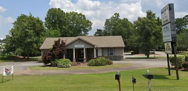
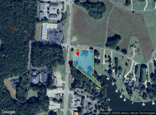
Property Record
102 Thunder Rd, Eatonton, GA 31024
Current Lease Availabilities
NEARBY LISTINGS FOR SALE OR LEASE
-
-
View all Eatonton listings for lease on LoopNet.com
Property Detail
102 Thunder Rd
Other Market Areas
Thunder Valley
102B109
Putnam
Singlefamilyresidentialassumed
Georgia
AE
1.81 AC
13211C0350B
Georgia Northeast
1,734 SF
DEMOGRAPHICS near 102 Thunder Rd
1 Mile
3 Mile
5 Mile
2024 Total Population
963
6,460
15,086
2029 Population
1,101
7,538
17,674
Pop Growth 2024-2029
+ 14.33%
+ 16.69%
+ 17.15%
Average Age
50
52
52
2024 Total Households
448
2,954
6,735
HH Growth 2024-2029
+ 14.73%
+ 16.66%
+ 16.99%
Median Household Inc
$58,420
$92,913
$95,133
Avg Household Size
2.10
2.10
2.20
2024 Avg HH Vehicles
2.00
2.00
2.00
Median Home Value
$457,142
$479,999
$484,066
Median Year Built
2001
2003
2003
Nearby Places
- Restaurants
- Banks
- Shops
- Fitness
- Groceries
Nearby Properties
Address
Land Use
TOTAL SIZE
Lot Size
Zoning
Address
Land Use
TOTAL SIZE
Lot Size
Zoning
122,249 SF
12.50 AC
Address
Land Use
TOTAL SIZE
Lot Size
Zoning
18,828 SF
14.89 AC
COMMERCIAL
Address
Land Use
TOTAL SIZE
Lot Size
Zoning
4,500 SF
9.13 AC
C-1
Address
Land Use
TOTAL SIZE
Lot Size
Zoning
66,844 SF
9.35 AC
Address
Land Use
TOTAL SIZE
Lot Size
Zoning
10,776 SF
3.36 AC
C-1
Address
Land Use
TOTAL SIZE
Lot Size
Zoning
2,300 SF
7.56 AC
C-2
Address
Land Use
TOTAL SIZE
Lot Size
Zoning
41,510 SF
2.95 AC
C-1
Address
Land Use
TOTAL SIZE
Lot Size
Zoning
11,245 SF
1.77 AC
Address
Land Use
TOTAL SIZE
Lot Size
Zoning
18,121 SF
17.45 AC
C-1
Address
Land Use
TOTAL SIZE
Lot Size
Zoning
28,044 SF
2.85 AC
Address
Land Use
TOTAL SIZE
Lot Size
Zoning
37,170 SF
2.70 AC
C-1
Address
Land Use
TOTAL SIZE
Lot Size
Zoning
22,800 SF
3.88 AC
C-2
Address
Land Use
TOTAL SIZE
Lot Size
Zoning
9,368 SF
8.29 AC
C-1
Address
Land Use
TOTAL SIZE
Lot Size
Zoning
12,564 SF
10 AC
R-1
Address
Land Use
TOTAL SIZE
Lot Size
Zoning
1,444 SF
3.96 AC
RM-3
Address
Land Use
TOTAL SIZE
Lot Size
Zoning
24,215 SF
3.81 AC
C-2
Address
Land Use
TOTAL SIZE
Lot Size
Zoning
9,375 SF
8.84 AC
I-M
Address
Land Use
TOTAL SIZE
Lot Size
Zoning
24,060 SF
3.20 AC
C-2
Address
Land Use
TOTAL SIZE
Lot Size
Zoning
6,196 SF
3.96 AC
Address
Land Use
TOTAL SIZE
Lot Size
Zoning
41,395 SF
6.43 AC
RM-1
Address
Land Use
TOTAL SIZE
Lot Size
Zoning
7,286 SF
0.51 AC
RM-3
Address
Land Use
TOTAL SIZE
Lot Size
Zoning
35,090 SF
3.67 AC
RM-3
Address
Land Use
TOTAL SIZE
Lot Size
Zoning
1,044 SF
307.88 AC
AG
Address
Land Use
TOTAL SIZE
Lot Size
Zoning
4,625 SF
2.17 AC
Address
Land Use
TOTAL SIZE
Lot Size
Zoning
11,250 SF
5.28 AC
C-1
Address
Land Use
TOTAL SIZE
Lot Size
Zoning
20,374 SF
2.03 AC
C-1
Address
Land Use
TOTAL SIZE
Lot Size
Zoning
15,300 SF
1.74 AC
C-2
Address
Land Use
TOTAL SIZE
Lot Size
Zoning
232.61 AC
RM-3
Address
Land Use
TOTAL SIZE
Lot Size
Zoning
9,712 SF
1.72 AC
C-1
Address
Land Use
TOTAL SIZE
Lot Size
Zoning
6,522 SF
89.49 AC
The World's #1 Commercial Real Estate Marketplace
Connect with us
© 2025 CoStar Group
The information above has been obtained from sources believed reliable. While we do not doubt its accuracy we have not verified it and make no guarantee, warranty or representation about it. It is your responsibility to independently confirm its accuracy and completeness. Any projections, opinions, assumptions, or estimates used are for example only and do not represent the current or future performance of the property. The value of this transaction to you depends on tax and other factors which should be evaluated by your tax, financial, and legal advisors. You and your advisors should conduct a careful, independent investigation of the property to determine to your satisfaction the suitability of the property for your needs.