Property Record
960 Burnt Meadow Rd, Hewitt, NJ 07421
NEARBY LISTINGS FOR SALE OR LEASE
Property Detail
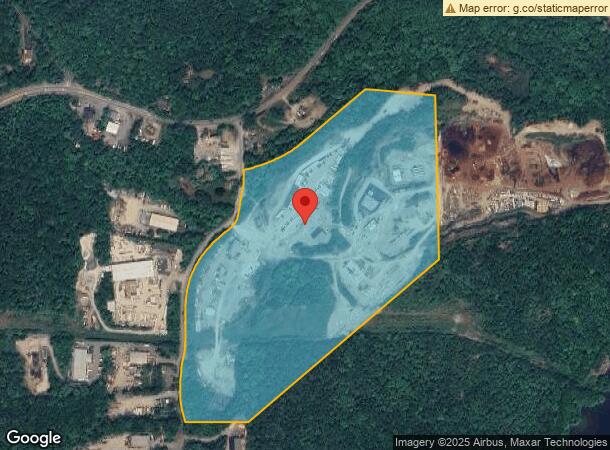
960 Burnt Meadow Rd
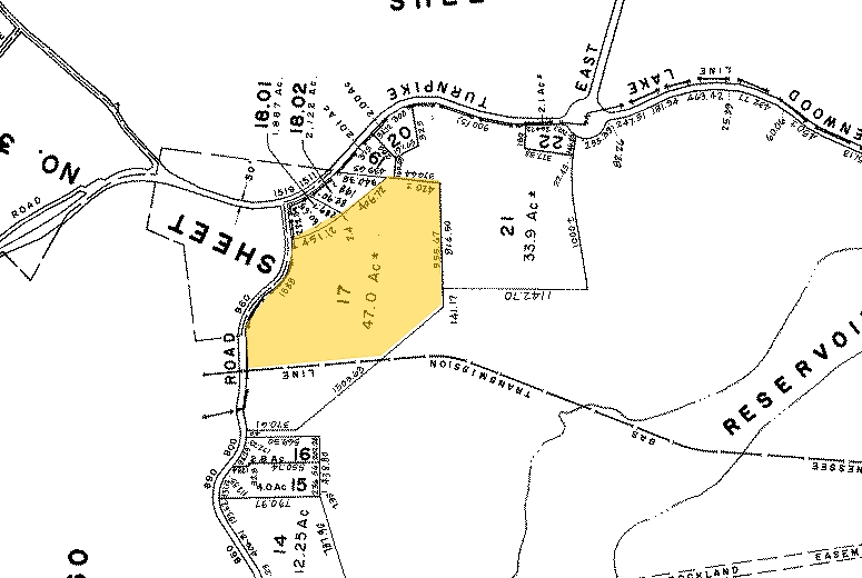
15-04601-0000-00017
Passaic
Warehouse
New Jersey
A
17
34031C0039G
47 AC
2023
Upper Suburban Passaic
2024
Northern New Jersey
256802
New York-Jersey City-White Plains, NY-NJ
DEMOGRAPHICS near 960 Burnt Meadow Rd
1 Mile
3 Mile
5 Mile
2024 Total Population
131
8,463
31,205
2029 Population
133
8,500
31,324
Pop Growth 2024-2029
+ 1.53%
+ 0.44%
+ 0.38%
Average Age
44
47
44
2024 Total Households
50
3,489
11,811
HH Growth 2024-2029
+ 2.00%
+ 0.26%
+ 0.25%
Median Household Inc
$111,363
$91,877
$109,912
Avg Household Size
2.60
2.40
2.50
2024 Avg HH Vehicles
2.00
2.00
2.00
Median Home Value
$407,692
$349,211
$370,654
Median Year Built
1969
1975
1969
Nearby Places
- Restaurants
- Banks
- Shops
- Fitness
- Groceries
PUBLIC TRANSPORTATION
COMMUTER RAIL
Sloatsburg (Bergen County/Port Jervis Line - NJ Transit Commuter Rail (NJ Transit), Main/Port Jervis Line - NJ Transit Commuter Rail (NJ Transit))
DRIVE
WALK
Distance
Sloatsburg (Bergen County/Port Jervis Line - NJ Transit Commuter Rail (NJ Transit), Main/Port Jervis Line - NJ Transit Commuter Rail (NJ Transit))
17 min
9.2 mi
AIRPORT
New York Stewart International
DRIVE
WALK
Distance
New York Stewart International
62 min
44.0 mi
Freight Ports
Port Newark Container Terminal
DRIVE
WALK
Distance
Port Newark Container Terminal
61 min
42.1 mi
Nearby Properties
Address
Land Use
TOTAL SIZE
Lot Size
Zoning
Address
Land Use
TOTAL SIZE
Lot Size
Zoning
12.50 AC
Address
Land Use
TOTAL SIZE
Lot Size
Zoning
Address
Land Use
TOTAL SIZE
Lot Size
Zoning
23,493 SF
5.54 AC
Address
Land Use
TOTAL SIZE
Lot Size
Zoning
798.60 AC
Address
Land Use
TOTAL SIZE
Lot Size
Zoning
Address
Land Use
TOTAL SIZE
Lot Size
Zoning
Address
Land Use
TOTAL SIZE
Lot Size
Zoning
1,344 SF
36.33 AC
Address
Land Use
TOTAL SIZE
Lot Size
Zoning
Address
Land Use
TOTAL SIZE
Lot Size
Zoning
Address
Land Use
TOTAL SIZE
Lot Size
Zoning
Address
Land Use
TOTAL SIZE
Lot Size
Zoning
Address
Land Use
TOTAL SIZE
Lot Size
Zoning
44,894 SF
3.54 AC
Address
Land Use
TOTAL SIZE
Lot Size
Zoning
Address
Land Use
TOTAL SIZE
Lot Size
Zoning
6.60 AC
Address
Land Use
TOTAL SIZE
Lot Size
Zoning
114.99 AC
Address
Land Use
TOTAL SIZE
Lot Size
Zoning
1,301 SF
1.51 AC
Address
Land Use
TOTAL SIZE
Lot Size
Zoning
Address
Land Use
TOTAL SIZE
Lot Size
Zoning
Address
Land Use
TOTAL SIZE
Lot Size
Zoning
57,156 SF
11.54 AC
Address
Land Use
TOTAL SIZE
Lot Size
Zoning
25,485 SF
10.23 AC
Address
Land Use
TOTAL SIZE
Lot Size
Zoning
3.25 AC
Address
Land Use
TOTAL SIZE
Lot Size
Zoning
Address
Land Use
TOTAL SIZE
Lot Size
Zoning
34,910 SF
2.76 AC
IND
Address
Land Use
TOTAL SIZE
Lot Size
Zoning
186.40 AC
Address
Land Use
TOTAL SIZE
Lot Size
Zoning
34,260 SF
3.46 AC
Address
Land Use
TOTAL SIZE
Lot Size
Zoning
5.51 AC
Address
Land Use
TOTAL SIZE
Lot Size
Zoning
Address
Land Use
TOTAL SIZE
Lot Size
Zoning
1.66 AC
Address
Land Use
TOTAL SIZE
Lot Size
Zoning
The World's #1 Commercial Real Estate Marketplace
Connect with us
© 2025 CoStar Group
The information above has been obtained from sources believed reliable. While we do not doubt its accuracy we have not verified it and make no guarantee, warranty or representation about it. It is your responsibility to independently confirm its accuracy and completeness. Any projections, opinions, assumptions, or estimates used are for example only and do not represent the current or future performance of the property. The value of this transaction to you depends on tax and other factors which should be evaluated by your tax, financial, and legal advisors. You and your advisors should conduct a careful, independent investigation of the property to determine to your satisfaction the suitability of the property for your needs.