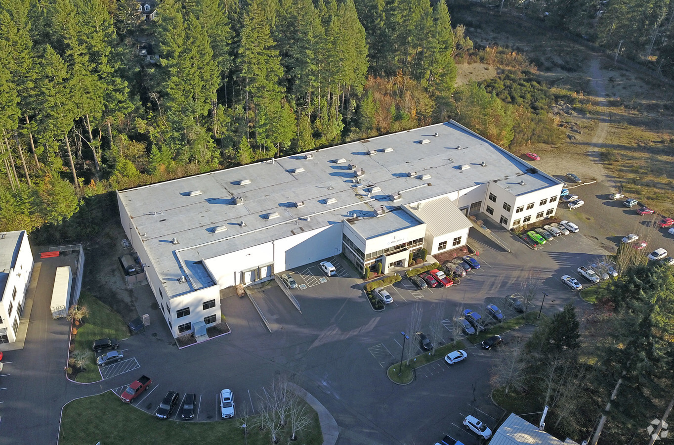
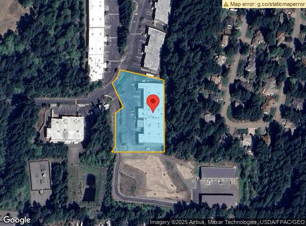
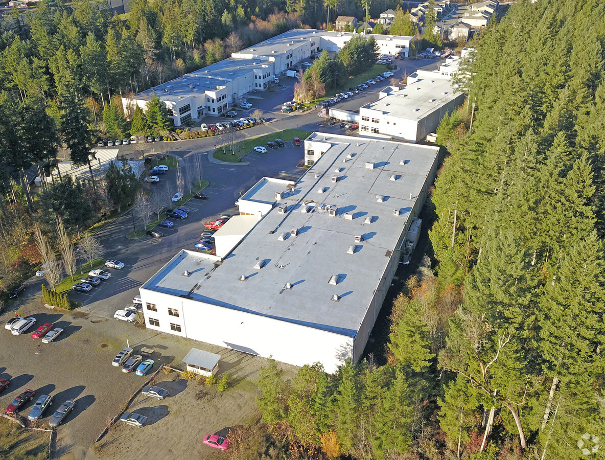
Property Record
9627 44Th Ave, Gig Harbor, WA 98332
NEARBY LISTINGS FOR SALE OR LEASE
-
-
No Photo
-
-
View all Gig Harbor listings for sale on LoopNet.com
Property Detail
9627 44Th Ave
Seattle-Tacoma-Bellevue, WA
Northarbor Business Campus Bsp (A)
400102-0061
SECTION 31 TOWNSHIP 22 RANGE 02 QUARTER 43 NORTHARBOR BUSINESS CAMPUS BSP (A) L 6 EASE OF RECORD OUT OF 006-0, 005-0, 007-0, 008-0 & 009-0 SEG I-0394 JU 12/4/96JU DC4/21/04JU 15156119DC 7/21/21 KG
Warehouse
Pierce
X
Washington
53033C1200G
6
2024
2.35 AC
2024
Gig Harbor/W Pierce
072509
Seattle/Puget Sound
40,090 SF
DEMOGRAPHICS near 9627 44Th Ave
1 Mile
3 Mile
5 Mile
2024 Total Population
4,603
28,286
54,416
2029 Population
4,790
29,368
56,129
Pop Growth 2024-2029
+ 4.06%
+ 3.83%
+ 3.15%
Average Age
46
45
45
2024 Total Households
1,897
11,059
21,064
HH Growth 2024-2029
+ 4.01%
+ 3.89%
+ 3.19%
Median Household Inc
$128,983
$124,183
$120,775
Avg Household Size
2.40
2.50
2.50
2024 Avg HH Vehicles
2.00
2.00
2.00
Median Home Value
$731,943
$727,798
$709,660
Median Year Built
2008
1992
1991
Nearby Places
- Restaurants
- Banks
- Shops
- Fitness
- Groceries
PUBLIC TRANSPORTATION
AIRPORT
Seattle-Tacoma International
DRIVE
WALK
Distance
Seattle-Tacoma International
53 min
34.7 mi
Freight Ports
Port of Tacoma
DRIVE
WALK
Distance
Port of Tacoma
25 min
16.3 mi
Nearby Properties
Address
Land Use
TOTAL SIZE
Lot Size
Zoning
Address
Land Use
TOTAL SIZE
Lot Size
Zoning
308,000 SF
23.44 AC
PCD-BP
Address
Land Use
TOTAL SIZE
Lot Size
Zoning
427,880 SF
17.97 AC
GIGH
Address
Land Use
TOTAL SIZE
Lot Size
Zoning
318,450 SF
36.63 AC
ED
Address
Land Use
TOTAL SIZE
Lot Size
Zoning
321,717 SF
75.30 AC
PI
Address
Land Use
TOTAL SIZE
Lot Size
Zoning
192,969 SF
11.52 AC
PRD
Address
Land Use
TOTAL SIZE
Lot Size
Zoning
297,754 SF
59.70 AC
PI
Address
Land Use
TOTAL SIZE
Lot Size
Zoning
115,222 SF
27.53 AC
Address
Land Use
TOTAL SIZE
Lot Size
Zoning
123,138 SF
14.89 AC
RB-2
Address
Land Use
TOTAL SIZE
Lot Size
Zoning
106,293 SF
7.60 AC
Address
Land Use
TOTAL SIZE
Lot Size
Zoning
71,494 SF
14.14 AC
Address
Land Use
TOTAL SIZE
Lot Size
Zoning
117,424 SF
24.84 AC
R-1
Address
Land Use
TOTAL SIZE
Lot Size
Zoning
92,797 SF
0.69 AC
PCD-BP
Address
Land Use
TOTAL SIZE
Lot Size
Zoning
129,455 SF
9.44 AC
RB-2
Address
Land Use
TOTAL SIZE
Lot Size
Zoning
295,242 SF
62 AC
PI
Address
Land Use
TOTAL SIZE
Lot Size
Zoning
110,156 SF
9.54 AC
B-2
Address
Land Use
TOTAL SIZE
Lot Size
Zoning
151,391 SF
17.49 AC
PCD-C
Address
Land Use
TOTAL SIZE
Lot Size
Zoning
104,043 SF
1.92 AC
B-2
Address
Land Use
TOTAL SIZE
Lot Size
Zoning
114,306 SF
6.54 AC
R-3
Address
Land Use
TOTAL SIZE
Lot Size
Zoning
62,960 SF
5.41 AC
C-1
Address
Land Use
TOTAL SIZE
Lot Size
Zoning
122,520 SF
10.76 AC
PCD-C
Address
Land Use
TOTAL SIZE
Lot Size
Zoning
77,906 SF
5 AC
R-1
Address
Land Use
TOTAL SIZE
Lot Size
Zoning
78,124 SF
4.65 AC
R-3
Address
Land Use
TOTAL SIZE
Lot Size
Zoning
105,563 SF
5.09 AC
B-2
Address
Land Use
TOTAL SIZE
Lot Size
Zoning
76,925 SF
11.63 AC
PI
Address
Land Use
TOTAL SIZE
Lot Size
Zoning
122,080 SF
16 AC
PCD-C
Address
Land Use
TOTAL SIZE
Lot Size
Zoning
77,755 SF
3.74 AC
ED
Address
Land Use
TOTAL SIZE
Lot Size
Zoning
2,312 SF
10.39 AC
RB-2
Address
Land Use
TOTAL SIZE
Lot Size
Zoning
58,428 SF
1.52 AC
RB-2
Address
Land Use
TOTAL SIZE
Lot Size
Zoning
55,066 SF
3.49 AC
R-3
Address
Land Use
TOTAL SIZE
Lot Size
Zoning
32,400 SF
1.12 AC
WC
The World's #1 Commercial Real Estate Marketplace
Connect with us
© 2025 CoStar Group
The information above has been obtained from sources believed reliable. While we do not doubt its accuracy we have not verified it and make no guarantee, warranty or representation about it. It is your responsibility to independently confirm its accuracy and completeness. Any projections, opinions, assumptions, or estimates used are for example only and do not represent the current or future performance of the property. The value of this transaction to you depends on tax and other factors which should be evaluated by your tax, financial, and legal advisors. You and your advisors should conduct a careful, independent investigation of the property to determine to your satisfaction the suitability of the property for your needs.