Property Record
97 S Groffdale Rd, Leola, PA 17540
NEARBY LISTINGS FOR SALE OR LEASE
-
-
View all Leola listings for sale on LoopNet.com
Property Detail
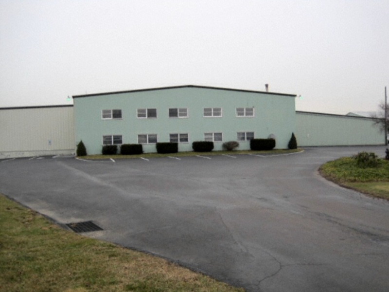
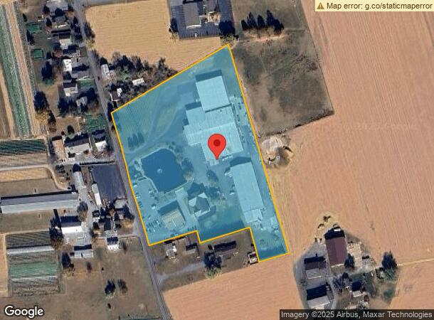
97 S Groffdale Rd
360-00457-0-0000
David J Yoder
Lightindustrial
97 S GROFFDALE RD
X
Lancaster
42071C0385F
Pennsylvania
2024
9.13 AC
2024
Lancaster County
013102
Philadelphia
90,079 SF
Lancaster, PA
DEMOGRAPHICS near 97 S Groffdale Rd
1 Mile
3 Mile
5 Mile
2024 Total Population
1,363
11,935
33,992
2029 Population
1,364
11,979
34,021
Pop Growth 2024-2029
+ 0.07%
+ 0.37%
+ 0.09%
Average Age
38
39
39
2024 Total Households
434
4,220
11,730
HH Growth 2024-2029
+ 0.23%
+ 0.50%
+ 0.26%
Median Household Inc
$85,156
$69,467
$74,309
Avg Household Size
3.00
2.80
2.80
2024 Avg HH Vehicles
2.00
2.00
2.00
Median Home Value
$275,961
$245,523
$283,391
Median Year Built
1975
1972
1976
Nearby Places
- Restaurants
- Banks
- Shops
- Fitness
- Groceries
Nearby Properties
Address
Land Use
TOTAL SIZE
Lot Size
Zoning
Address
Land Use
TOTAL SIZE
Lot Size
Zoning
2,615,989 SF
147.50 AC
I
Address
Land Use
TOTAL SIZE
Lot Size
Zoning
678,098 SF
40.91 AC
Address
Land Use
TOTAL SIZE
Lot Size
Zoning
137,682 SF
8.73 AC
R-2
Address
Land Use
TOTAL SIZE
Lot Size
Zoning
232,238 SF
74.26 AC
M
Address
Land Use
TOTAL SIZE
Lot Size
Zoning
90,944 SF
8.92 AC
Address
Land Use
TOTAL SIZE
Lot Size
Zoning
83,852 SF
11.59 AC
I
Address
Land Use
TOTAL SIZE
Lot Size
Zoning
148,232 SF
10.61 AC
I
Address
Land Use
TOTAL SIZE
Lot Size
Zoning
148,917 SF
9.85 AC
C-2
Address
Land Use
TOTAL SIZE
Lot Size
Zoning
48,827 SF
7.60 AC
GC
Address
Land Use
TOTAL SIZE
Lot Size
Zoning
112,160 SF
8.20 AC
M
Address
Land Use
TOTAL SIZE
Lot Size
Zoning
133,788 SF
10.10 AC
I
Address
Land Use
TOTAL SIZE
Lot Size
Zoning
129,024 SF
15.80 AC
M
Address
Land Use
TOTAL SIZE
Lot Size
Zoning
109,396 SF
19.60 AC
I
Address
Land Use
TOTAL SIZE
Lot Size
Zoning
64,363 SF
9.10 AC
C
Address
Land Use
TOTAL SIZE
Lot Size
Zoning
112,433 SF
14.60 AC
Address
Land Use
TOTAL SIZE
Lot Size
Zoning
66,473 SF
4.40 AC
I
Address
Land Use
TOTAL SIZE
Lot Size
Zoning
67,400 SF
9.50 AC
I
Address
Land Use
TOTAL SIZE
Lot Size
Zoning
96,870 SF
10.98 AC
I
Address
Land Use
TOTAL SIZE
Lot Size
Zoning
9,387 SF
16.55 AC
Address
Land Use
TOTAL SIZE
Lot Size
Zoning
106,542 SF
19.30 AC
I
Address
Land Use
TOTAL SIZE
Lot Size
Zoning
106,816 SF
8.50 AC
R-2
Address
Land Use
TOTAL SIZE
Lot Size
Zoning
96,536 SF
15.10 AC
I
Address
Land Use
TOTAL SIZE
Lot Size
Zoning
70,190 SF
10.28 AC
I
Address
Land Use
TOTAL SIZE
Lot Size
Zoning
98,586 SF
9.60 AC
I
Address
Land Use
TOTAL SIZE
Lot Size
Zoning
18,879 SF
7.60 AC
A
Address
Land Use
TOTAL SIZE
Lot Size
Zoning
108,675 SF
30.53 AC
I
Address
Land Use
TOTAL SIZE
Lot Size
Zoning
47,041 SF
11.20 AC
R-2
Address
Land Use
TOTAL SIZE
Lot Size
Zoning
27,136 SF
3.40 AC
Address
Land Use
TOTAL SIZE
Lot Size
Zoning
60,568 SF
8.80 AC
I
Address
Land Use
TOTAL SIZE
Lot Size
Zoning
56,220 SF
19.18 AC
The World's #1 Commercial Real Estate Marketplace
Connect with us
© 2025 CoStar Group
The information above has been obtained from sources believed reliable. While we do not doubt its accuracy we have not verified it and make no guarantee, warranty or representation about it. It is your responsibility to independently confirm its accuracy and completeness. Any projections, opinions, assumptions, or estimates used are for example only and do not represent the current or future performance of the property. The value of this transaction to you depends on tax and other factors which should be evaluated by your tax, financial, and legal advisors. You and your advisors should conduct a careful, independent investigation of the property to determine to your satisfaction the suitability of the property for your needs.