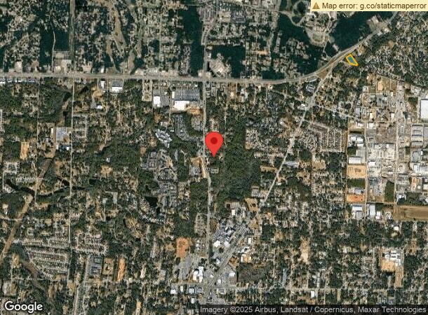
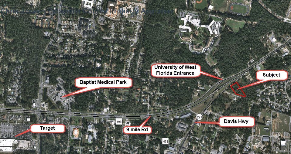
Property Record
9700 Blk Davis Hwy, Pensacola, FL 32514

This Property Is For Sale
NEARBY LISTINGS FOR SALE OR LEASE
Property Detail
9700 Blk Davis Hwy
Pensacola-Ferry Pass-Brent, FL
Hillside
02-1S-30-0601-000-021
ALL LTS 21 22 OR 1185 P 371 HILLSIDE S/D PB 1 P 43
Commercialacreage
Escambia
X
Florida
12113C0415H
21
2023
1.80 AC
2024
Ferry Pass/N Pensacola
003507
Pensacola
DEMOGRAPHICS near 9700 Blk Davis Hwy
1 Mile
3 Mile
5 Mile
2024 Total Population
5,774
36,534
86,728
2029 Population
5,958
37,063
88,336
Pop Growth 2024-2029
+ 3.19%
+ 1.45%
+ 1.85%
Average Age
44
40
39
2024 Total Households
2,205
15,909
35,211
HH Growth 2024-2029
+ 3.27%
+ 1.36%
+ 1.86%
Median Household Inc
$47,745
$52,360
$55,119
Avg Household Size
2.10
2.10
2.20
2024 Avg HH Vehicles
2.00
2.00
2.00
Median Home Value
$249,305
$205,310
$210,087
Median Year Built
1989
1984
1982
Nearby Places
- Restaurants
- Banks
- Shops
- Fitness
- Groceries
PUBLIC TRANSPORTATION
AIRPORT
Pensacola International
DRIVE
WALK
Distance
Pensacola International
15 min
6.5 mi
Freight Ports
Port of Mobile
DRIVE
WALK
Distance
Port of Mobile
63 min
54.9 mi
Nearby Properties
Address
Land Use
TOTAL SIZE
Lot Size
Zoning
Address
Land Use
TOTAL SIZE
Lot Size
Zoning
1 AC
PUB
Address
Land Use
TOTAL SIZE
Lot Size
Zoning
368,851 SF
19.16 AC
HDMU,REC
Address
Land Use
TOTAL SIZE
Lot Size
Zoning
544,759 SF
20.06 AC
COM
Address
Land Use
TOTAL SIZE
Lot Size
Zoning
336,376 SF
19.68 AC
HDMU
Address
Land Use
TOTAL SIZE
Lot Size
Zoning
553,808 SF
35.16 AC
HDR
Address
Land Use
TOTAL SIZE
Lot Size
Zoning
266,096 SF
13.46 AC
HDMU
Address
Land Use
TOTAL SIZE
Lot Size
Zoning
314,269 SF
12.53 AC
HDMU
Address
Land Use
TOTAL SIZE
Lot Size
Zoning
269,404 SF
23.85 AC
HDMU
Address
Land Use
TOTAL SIZE
Lot Size
Zoning
238,060 SF
21.93 AC
HDMU
Address
Land Use
TOTAL SIZE
Lot Size
Zoning
262,823 SF
11.57 AC
HDMU
Address
Land Use
TOTAL SIZE
Lot Size
Zoning
240,998 SF
18.63 AC
HDMU
Address
Land Use
TOTAL SIZE
Lot Size
Zoning
210,644 SF
13.14 AC
R-2
Address
Land Use
TOTAL SIZE
Lot Size
Zoning
203,587 SF
20.11 AC
HDR
Address
Land Use
TOTAL SIZE
Lot Size
Zoning
191,157 SF
11.77 AC
MDR
Address
Land Use
TOTAL SIZE
Lot Size
Zoning
329,935 SF
46.34 AC
COM
Address
Land Use
TOTAL SIZE
Lot Size
Zoning
275,458 SF
8.29 AC
HDMU
Address
Land Use
TOTAL SIZE
Lot Size
Zoning
171,283 SF
3.89 AC
HDR
Address
Land Use
TOTAL SIZE
Lot Size
Zoning
202,638 SF
9.43 AC
HDMU
Address
Land Use
TOTAL SIZE
Lot Size
Zoning
517,415 SF
27.78 AC
HC/LI
Address
Land Use
TOTAL SIZE
Lot Size
Zoning
263,938 SF
58.17 AC
C-1,R-1AA,
Address
Land Use
TOTAL SIZE
Lot Size
Zoning
175,834 SF
14.17 AC
COM
Address
Land Use
TOTAL SIZE
Lot Size
Zoning
112,265 SF
25.22 AC
COM
Address
Land Use
TOTAL SIZE
Lot Size
Zoning
68,810 SF
182 AC
IND
Address
Land Use
TOTAL SIZE
Lot Size
Zoning
193,321 SF
15.03 AC
HDR
Address
Land Use
TOTAL SIZE
Lot Size
Zoning
189,008 SF
9.56 AC
R-2A
Address
Land Use
TOTAL SIZE
Lot Size
Zoning
158,190 SF
22.79 AC
HC/LI
Address
Land Use
TOTAL SIZE
Lot Size
Zoning
176,462 SF
9.51 AC
HDR
Address
Land Use
TOTAL SIZE
Lot Size
Zoning
103,111 SF
12.02 AC
C-1
Address
Land Use
TOTAL SIZE
Lot Size
Zoning
236,704 SF
35.17 AC
R-1AA
Address
Land Use
TOTAL SIZE
Lot Size
Zoning
151,275 SF
6.79 AC
R-2A
The World's #1 Commercial Real Estate Marketplace
Connect with us
© 2025 CoStar Group
The information above has been obtained from sources believed reliable. While we do not doubt its accuracy we have not verified it and make no guarantee, warranty or representation about it. It is your responsibility to independently confirm its accuracy and completeness. Any projections, opinions, assumptions, or estimates used are for example only and do not represent the current or future performance of the property. The value of this transaction to you depends on tax and other factors which should be evaluated by your tax, financial, and legal advisors. You and your advisors should conduct a careful, independent investigation of the property to determine to your satisfaction the suitability of the property for your needs.