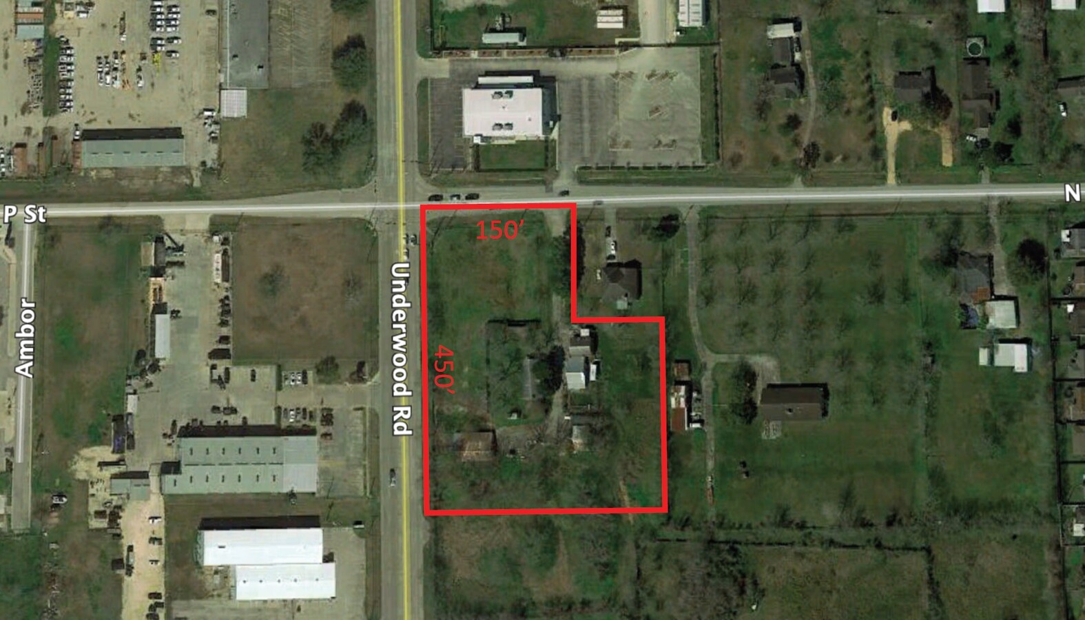
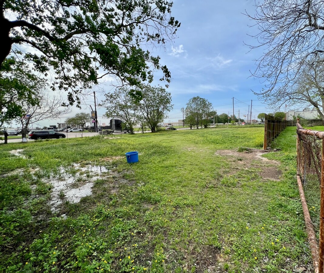
Property Record
9716 N P St, La Porte, TX 77571

NEARBY LISTINGS FOR SALE OR LEASE
-
-
No Photo
-
-
-
-
-
-
-
-
-
-
View all La Porte listings for sale on LoopNet.com
Property Detail
9716 N P St
Houston-The Woodlands-Sugar Land, TX
La Porte Outlots
0231400000410
Harris
Sfr
Texas
X
3.51 AC
48201C0940M
Gulf Freeway/Pasadena
1,260 SF
Houston
DEMOGRAPHICS near 9716 N P St
1 Mile
3 Mile
5 Mile
2024 Total Population
6,403
56,821
103,655
2029 Population
6,463
57,818
105,617
Pop Growth 2024-2029
+ 0.94%
+ 1.75%
+ 1.89%
Average Age
37
38
38
2024 Total Households
2,082
19,825
36,237
HH Growth 2024-2029
+ 0.91%
+ 1.72%
+ 1.84%
Median Household Inc
$113,272
$82,873
$76,432
Avg Household Size
3.00
2.80
2.80
2024 Avg HH Vehicles
2.00
2.00
2.00
Median Home Value
$261,300
$216,104
$204,679
Median Year Built
1996
1983
1983
Nearby Places
- Restaurants
- Banks
- Shops
- Fitness
- Groceries
PUBLIC TRANSPORTATION
AIRPORT
William P Hobby
DRIVE
WALK
Distance
William P Hobby
31 min
15.7 mi
George Bush Intcntl/Houston
DRIVE
WALK
Distance
George Bush Intcntl/Houston
42 min
32.4 mi
Freight Ports
Port of Houston
DRIVE
WALK
Distance
Port of Houston
24 min
15.3 mi
SALE & LEASE HISTORY
LISTING DATE
SALE/LEASE

Mar 13, 2020
For Sale
Jun 10, 2019
For Sale
Aug 09, 2022
For Sale
Nearby Properties
Address
Land Use
TOTAL SIZE
Lot Size
Zoning
Address
Land Use
TOTAL SIZE
Lot Size
Zoning
Address
Land Use
TOTAL SIZE
Lot Size
Zoning
55.98 AC
Address
Land Use
TOTAL SIZE
Lot Size
Zoning
Address
Land Use
TOTAL SIZE
Lot Size
Zoning
4,960,504 SF
141.62 AC
Address
Land Use
TOTAL SIZE
Lot Size
Zoning
36.31 AC
Address
Land Use
TOTAL SIZE
Lot Size
Zoning
13.76 AC
Address
Land Use
TOTAL SIZE
Lot Size
Zoning
64.83 AC
Address
Land Use
TOTAL SIZE
Lot Size
Zoning
Address
Land Use
TOTAL SIZE
Lot Size
Zoning
67.91 AC
Address
Land Use
TOTAL SIZE
Lot Size
Zoning
Address
Land Use
TOTAL SIZE
Lot Size
Zoning
46.10 AC
Address
Land Use
TOTAL SIZE
Lot Size
Zoning
28.34 AC
Address
Land Use
TOTAL SIZE
Lot Size
Zoning
900,000 SF
42.88 AC
Address
Land Use
TOTAL SIZE
Lot Size
Zoning
1,126,350 SF
35.24 AC
Address
Land Use
TOTAL SIZE
Lot Size
Zoning
120.26 AC
Address
Land Use
TOTAL SIZE
Lot Size
Zoning
767,630 SF
41.71 AC
Address
Land Use
TOTAL SIZE
Lot Size
Zoning
711,094 SF
35.47 AC
Address
Land Use
TOTAL SIZE
Lot Size
Zoning
66.50 AC
Address
Land Use
TOTAL SIZE
Lot Size
Zoning
197.11 AC
Address
Land Use
TOTAL SIZE
Lot Size
Zoning
155.74 AC
Address
Land Use
TOTAL SIZE
Lot Size
Zoning
Address
Land Use
TOTAL SIZE
Lot Size
Zoning
335,636 SF
18.02 AC
Address
Land Use
TOTAL SIZE
Lot Size
Zoning
562,760 SF
21.90 AC
Address
Land Use
TOTAL SIZE
Lot Size
Zoning
Address
Land Use
TOTAL SIZE
Lot Size
Zoning
38.51 AC
Address
Land Use
TOTAL SIZE
Lot Size
Zoning
45.18 AC
Address
Land Use
TOTAL SIZE
Lot Size
Zoning
26.28 AC
Address
Land Use
TOTAL SIZE
Lot Size
Zoning
414,900 SF
25.29 AC
Address
Land Use
TOTAL SIZE
Lot Size
Zoning
95.07 AC
Address
Land Use
TOTAL SIZE
Lot Size
Zoning
The World's #1 Commercial Real Estate Marketplace
Connect with us
© 2025 CoStar Group
The information above has been obtained from sources believed reliable. While we do not doubt its accuracy we have not verified it and make no guarantee, warranty or representation about it. It is your responsibility to independently confirm its accuracy and completeness. Any projections, opinions, assumptions, or estimates used are for example only and do not represent the current or future performance of the property. The value of this transaction to you depends on tax and other factors which should be evaluated by your tax, financial, and legal advisors. You and your advisors should conduct a careful, independent investigation of the property to determine to your satisfaction the suitability of the property for your needs.