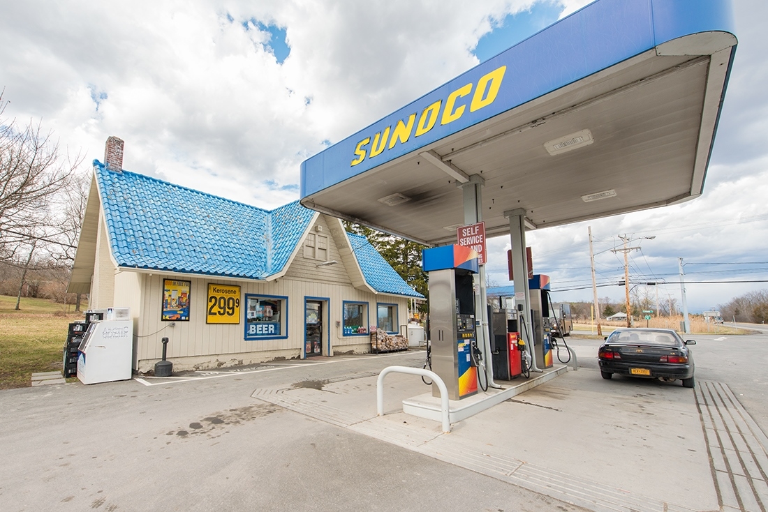
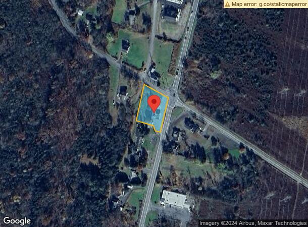
Property Record
9763 Us Route 9W, Athens, NY 12015
NEARBY LISTINGS FOR SALE OR LEASE
-
-
View all Athens listings for sale on LoopNet.com
Property Detail
9763 Us Route 9W
Servicestation
Greene
X
New York
36039C0286F
9.000
2024
0.67 AC
2023
Greene County
080900
Albany/Schenectady/Troy
880 SF
192289-104-000-0006-009-000-0000
DEMOGRAPHICS near 9763 Us Route 9W
1 Mile
3 Mile
5 Mile
2024 Total Population
219
4,593
20,034
2029 Population
221
4,756
20,319
Pop Growth 2024-2029
+ 0.91%
+ 3.55%
+ 1.42%
Average Age
45
46
44
2024 Total Households
97
2,032
9,007
HH Growth 2024-2029
+ 1.03%
+ 3.35%
+ 1.35%
Median Household Inc
$70,434
$76,926
$57,964
Avg Household Size
2.30
2.30
2.10
2024 Avg HH Vehicles
2.00
2.00
2.00
Median Home Value
$169,565
$231,058
$217,814
Median Year Built
1969
1984
1963
Nearby Places
- Restaurants
- Banks
- Shops
- Fitness
- Groceries
PUBLIC TRANSPORTATION
AIRPORT
Albany International
DRIVE
WALK
Distance
Albany International
46 min
39.9 mi
SALE & LEASE HISTORY
LISTING DATE
SALE/LEASE

Sep 23, 2016
For Sale
Sep 23, 2016
For Sale
Oct 04, 2016
For Sale
Nov 23, 2016
For Sale
Nearby Properties
Address
Land Use
TOTAL SIZE
Lot Size
Zoning
Address
Land Use
TOTAL SIZE
Lot Size
Zoning
83.45 AC
02 - SINGL
Address
Land Use
TOTAL SIZE
Lot Size
Zoning
0.97 AC
03 - MULTI
Address
Land Use
TOTAL SIZE
Lot Size
Zoning
4,250 SF
33.20 AC
06 - INDUS
Address
Land Use
TOTAL SIZE
Lot Size
Zoning
126.10 AC
02 - SINGL
Address
Land Use
TOTAL SIZE
Lot Size
Zoning
Address
Land Use
TOTAL SIZE
Lot Size
Zoning
1,920 SF
32.24 AC
06 - INDUS
Address
Land Use
TOTAL SIZE
Lot Size
Zoning
Address
Land Use
TOTAL SIZE
Lot Size
Zoning
15,750 SF
77.20 AC
02 - SINGL
Address
Land Use
TOTAL SIZE
Lot Size
Zoning
53.93 AC
06 - INDUS
Address
Land Use
TOTAL SIZE
Lot Size
Zoning
43,945 SF
20.60 AC
03 - MULTI
Address
Land Use
TOTAL SIZE
Lot Size
Zoning
22,954 SF
144.64 AC
02 - SINGL
Address
Land Use
TOTAL SIZE
Lot Size
Zoning
22,346 SF
4.67 AC
06 - INDUS
Address
Land Use
TOTAL SIZE
Lot Size
Zoning
2,160 SF
3.30 AC
03 - MULTI
Address
Land Use
TOTAL SIZE
Lot Size
Zoning
Address
Land Use
TOTAL SIZE
Lot Size
Zoning
Address
Land Use
TOTAL SIZE
Lot Size
Zoning
Address
Land Use
TOTAL SIZE
Lot Size
Zoning
19,744 SF
0.90 AC
03 - MULTI
Address
Land Use
TOTAL SIZE
Lot Size
Zoning
960 SF
57.60 AC
99
Address
Land Use
TOTAL SIZE
Lot Size
Zoning
Address
Land Use
TOTAL SIZE
Lot Size
Zoning
Address
Land Use
TOTAL SIZE
Lot Size
Zoning
20,808 SF
31 AC
06 - INDUS
Address
Land Use
TOTAL SIZE
Lot Size
Zoning
7,488 SF
3.96 AC
06 - INDUS
Address
Land Use
TOTAL SIZE
Lot Size
Zoning
Address
Land Use
TOTAL SIZE
Lot Size
Zoning
15,648 SF
1.38 AC
03 - MULTI
Address
Land Use
TOTAL SIZE
Lot Size
Zoning
1,152 SF
68.90 AC
04 - FARM
Address
Land Use
TOTAL SIZE
Lot Size
Zoning
3,528 SF
0.36 AC
03 - MULTI
Address
Land Use
TOTAL SIZE
Lot Size
Zoning
3,846 SF
18.49 AC
05 - COMME
Address
Land Use
TOTAL SIZE
Lot Size
Zoning
0.01 AC
06
Address
Land Use
TOTAL SIZE
Lot Size
Zoning
Address
Land Use
TOTAL SIZE
Lot Size
Zoning
The World's #1 Commercial Real Estate Marketplace
Connect with us
© 2025 CoStar Group
The information above has been obtained from sources believed reliable. While we do not doubt its accuracy we have not verified it and make no guarantee, warranty or representation about it. It is your responsibility to independently confirm its accuracy and completeness. Any projections, opinions, assumptions, or estimates used are for example only and do not represent the current or future performance of the property. The value of this transaction to you depends on tax and other factors which should be evaluated by your tax, financial, and legal advisors. You and your advisors should conduct a careful, independent investigation of the property to determine to your satisfaction the suitability of the property for your needs.