Property Record
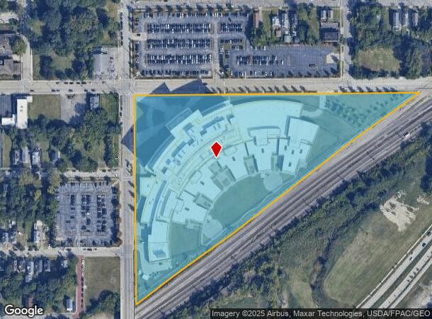
9812 Quincy Ave, Cleveland, OH 44104
NEARBY LISTINGS FOR SALE OR LEASE
Property Detail
9812 Quincy Ave
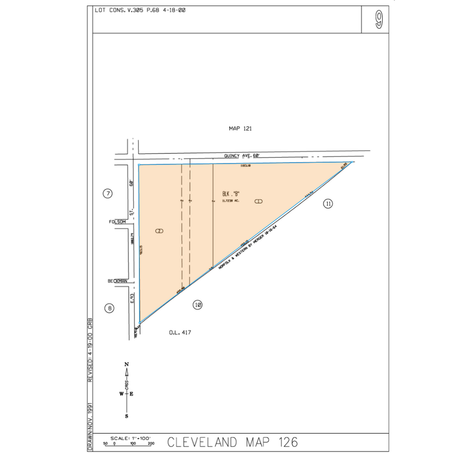
126-09-001
417 BLKB 12609002
Countyproperty
Cuyahoga
X
Ohio
39035C0201E
417
0
11.72 AC
2024
East
198500
Cleveland
607,500 SF
Cleveland-Elyria, OH
DEMOGRAPHICS near 9812 Quincy Ave
1 Mile
3 Mile
5 Mile
2024 Total Population
11,339
138,764
319,976
2029 Population
11,250
137,226
315,909
Pop Growth 2024-2029
(0.78%)
(1.11%)
(1.27%)
Average Age
39
39
39
2024 Total Households
5,330
62,828
144,538
HH Growth 2024-2029
(0.71%)
(1.12%)
(1.23%)
Median Household Inc
$25,428
$29,780
$38,100
Avg Household Size
2.00
2.00
2.10
2024 Avg HH Vehicles
1.00
1.00
1.00
Median Home Value
$83,165
$89,577
$100,654
Median Year Built
1949
1947
1948
Nearby Places
- Restaurants
- Banks
- Shops
- Fitness
- Groceries
PUBLIC TRANSPORTATION
TRANSIT/SUBWAY
East 105 - Quincy (Red Line - Greater Cleveland Regional Transit Authority Rapid Transit (The Rapid))
DRIVE
WALK
Distance
East 105 - Quincy (Red Line - Greater Cleveland Regional Transit Authority Rapid Transit (The Rapid))
0 min
4 min
0.2 mi
Woodhill (Blue Line - Greater Cleveland Regional Transit Authority Rapid Transit (The Rapid), Green Line - Greater Cleveland Regional Transit Authority Rapid Transit (The Rapid))
DRIVE
WALK
Distance
Woodhill (Blue Line - Greater Cleveland Regional Transit Authority Rapid Transit (The Rapid), Green Line - Greater Cleveland Regional Transit Authority Rapid Transit (The Rapid))
3 min
18 min
1.0 mi
COMMUTER RAIL
Cleveland Lakefront Station (Blue Line - Greater Cleveland Regional Transit Authority Rapid Transit (The Rapid), Green Line - Greater Cleveland Regional Transit Authority Rapid Transit (The Rapid))
DRIVE
WALK
Distance
Cleveland Lakefront Station (Blue Line - Greater Cleveland Regional Transit Authority Rapid Transit (The Rapid), Green Line - Greater Cleveland Regional Transit Authority Rapid Transit (The Rapid))
15 min
5.5 mi
Rockside (National Park Scenic Railway - Cuyahoga Valley Scenic Railroad)
DRIVE
WALK
Distance
Rockside (National Park Scenic Railway - Cuyahoga Valley Scenic Railroad)
18 min
9.7 mi
AIRPORT
Cleveland-Hopkins International
DRIVE
WALK
Distance
Cleveland-Hopkins International
27 min
15.8 mi
Freight Ports
Port of Toledo
DRIVE
WALK
Distance
Port of Toledo
141 min
116.3 mi
Nearby Properties
Address
Land Use
TOTAL SIZE
Lot Size
Zoning
Address
Land Use
TOTAL SIZE
Lot Size
Zoning
3,172,147 SF
20.33 AC
GR
Address
Land Use
TOTAL SIZE
Lot Size
Zoning
1,211,519 SF
13.57 AC
GR
Address
Land Use
TOTAL SIZE
Lot Size
Zoning
2,064,168 SF
17.90 AC
GR
Address
Land Use
TOTAL SIZE
Lot Size
Zoning
1,104,152 SF
13.96 AC
GR
Address
Land Use
TOTAL SIZE
Lot Size
Zoning
942,168 SF
8.34 AC
IR
Address
Land Use
TOTAL SIZE
Lot Size
Zoning
53.85 AC
2F
Address
Land Use
TOTAL SIZE
Lot Size
Zoning
1,211,519 SF
13.63 AC
GR
Address
Land Use
TOTAL SIZE
Lot Size
Zoning
484,355 SF
11.60 AC
GR
Address
Land Use
TOTAL SIZE
Lot Size
Zoning
370,230 SF
4.08 AC
GR
Address
Land Use
TOTAL SIZE
Lot Size
Zoning
1,151,581 SF
10.13 AC
L1F
Address
Land Use
TOTAL SIZE
Lot Size
Zoning
500,042 SF
1.34 AC
1F
Address
Land Use
TOTAL SIZE
Lot Size
Zoning
765,607 SF
12.15 AC
GR
Address
Land Use
TOTAL SIZE
Lot Size
Zoning
788,580 SF
4.85 AC
GR
Address
Land Use
TOTAL SIZE
Lot Size
Zoning
1,227,793 SF
6.80 AC
GR
Address
Land Use
TOTAL SIZE
Lot Size
Zoning
595,671 SF
14.98 AC
MF3+
Address
Land Use
TOTAL SIZE
Lot Size
Zoning
128,967 SF
3.54 AC
Address
Land Use
TOTAL SIZE
Lot Size
Zoning
913,527 SF
5.16 AC
GR
Address
Land Use
TOTAL SIZE
Lot Size
Zoning
942,168 SF
9.93 AC
IR
Address
Land Use
TOTAL SIZE
Lot Size
Zoning
707,658 SF
17.57 AC
2F
Address
Land Use
TOTAL SIZE
Lot Size
Zoning
230,820 SF
41.47 AC
UI
Address
Land Use
TOTAL SIZE
Lot Size
Zoning
243,720 SF
0.20 AC
GR
Address
Land Use
TOTAL SIZE
Lot Size
Zoning
374,227 SF
13.10 AC
MF3+
Address
Land Use
TOTAL SIZE
Lot Size
Zoning
724,884 SF
8.67 AC
Address
Land Use
TOTAL SIZE
Lot Size
Zoning
435,964 SF
55.02 AC
1F
Address
Land Use
TOTAL SIZE
Lot Size
Zoning
455,560 SF
1.23 AC
GR
Address
Land Use
TOTAL SIZE
Lot Size
Zoning
1,181,536 SF
27.82 AC
RO
Address
Land Use
TOTAL SIZE
Lot Size
Zoning
395,625 SF
0.74 AC
Address
Land Use
TOTAL SIZE
Lot Size
Zoning
745,953 SF
14.34 AC
MF3+
Address
Land Use
TOTAL SIZE
Lot Size
Zoning
767,400 SF
0.27 AC
GR
The World's #1 Commercial Real Estate Marketplace
Connect with us
© 2025 CoStar Group
The information above has been obtained from sources believed reliable. While we do not doubt its accuracy we have not verified it and make no guarantee, warranty or representation about it. It is your responsibility to independently confirm its accuracy and completeness. Any projections, opinions, assumptions, or estimates used are for example only and do not represent the current or future performance of the property. The value of this transaction to you depends on tax and other factors which should be evaluated by your tax, financial, and legal advisors. You and your advisors should conduct a careful, independent investigation of the property to determine to your satisfaction the suitability of the property for your needs.